Written and Fact-checked by Whereig Editors | Updated On: May 05, 2026 | 14:50 ET
Map of Richland County - Richland County is a county located in the U.S. state of South Carolina. Richland County Map showing cities, highways, important places and water bodies. Get Where is Richland County located in the map, major cities in Richland county, population, areas, and places of interest.
Map of Richland County, South Carolina
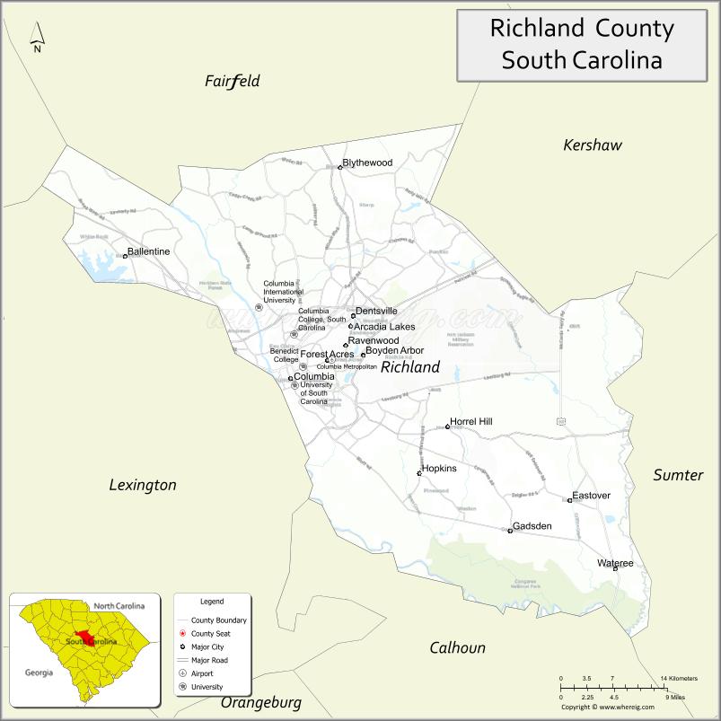
About Richland County Map, South Carolina: The map showing the county boundary, county seat, major cities, highways, water bodies and neighbouring counties.
Related South Carolina Links
Map of Richland County, South Carolina
Richland County is a county located in the U.S. state of South Carolina. It's county seat is Columbia. As per 2020 census, the population of Richland County is 418307 people and population density is square miles. According to the United States Census Bureau, the county has a total area of 772 sq mi (1,999 km2). Richland County was established on 1799.
Richland County Facts
| Continent | North America |
| Country | United States |
| State | South Carolina |
| County Seat | Columbia |
| Largest City/Town | Columbia |
| Established | 1785 |
| Total Area | 772.90 sq mi (2,001.81 sq km) |
| Land Area | 756.17 sq mi (1,958.47 sq km) |
| Water Area | 16.73 sq mi (43.34 sq km) |
| Population | 416,147 (Census 2020) |
| Population Density | 550.2 people per sq mi |
| Time Zone | Eastern (EST) |
| Major Highways | I-20, I-26, I-77, US-1, US-21, US-76, US-321 |
| Major Rivers | Congaree River, Broad River, Saluda River |
| Neighboring Counties | Kershaw, Fairfield, Newberry, Lexington, Calhoun, Sumter |
| Famous For | State capital Columbia, University of South Carolina, government and education |
| Top Attractions | South Carolina State House, Riverbanks Zoo & Garden, Congaree National Park (nearby), Columbia Museum of Art |
| Official Website | Official Website |
About Richland County, South Carolina
Richland County is located in the central part of South Carolina in the United States and was established in 1785. The county seat is Columbia, which is also the largest city and the state capital. The county lies in the Midlands region and is known for its role as a political, educational, and cultural center of the state.
Cities and Towns in Richland County, South Carolina
| City/Town | Population (Census 2020) | Latitude & Longitude |
|---|---|---|
| Columbia (county seat) | 136,632 | 34.0007N, 81.0348W |
| Forest Acres | 10,000+ | 34.0200N, 80.9800W |
| Arcadia Lakes | 800 | 34.0200N, 80.9600W |
| Eastover | 800 | 33.9000N, 80.7000W |
| Blythewood | 4,400+ | 34.2140N, 80.9737W |
| Irmo (partly) | 12,000+ | 34.0854N, 81.1832W |
| Dentsville (CDP) | 14,000+ | 34.0600N, 80.9600W |
| Woodfield (CDP) | 9,000+ | 34.0500N, 80.9300W |
Golf Courses in Richland County, South Carolina
| Golf Course | Location | Latitude & Longitude |
|---|---|---|
| Forest Lake Club | Columbia | 34.0200N, 80.9900W |
| Columbia Country Club | Blythewood | 34.2100N, 80.9800W |
| Oak Hills Golf Club | Columbia area | 34.0500N, 81.1500W |
| LinRick Golf Course | Columbia | 34.1000N, 80.9900W |
Roads and Highways in Richland County, South Carolina
The county is a major transportation hub with multiple interstate highways.
- I-20 - connects Columbia to Atlanta and Florence
- I-26 - links Columbia to Charleston and the Upstate
- I-77 - connects Columbia to Charlotte and the Southeast
- US-1, US-21, US-76, US-321 - major routes serving the county
Neighboring Counties of Richland County
- Kershaw County (north)
- Fairfield County (northwest)
- Newberry County (west)
- Lexington County (west)
- Calhoun County (southeast)
- Sumter County (east)
Top Attractions in Richland County, South Carolina
The county is a major cultural and recreational destination in South Carolina.
- South Carolina State House - historic government building
- Riverbanks Zoo & Garden - popular zoo and botanical garden
- Congaree National Park (nearby) - old-growth forest and hiking
- Columbia Museum of Art - art collections and exhibitions
- Lake Murray (nearby) - boating and recreation
- Five Points District - dining, shopping, and nightlife
Distance from Richland County to Nearby Cities
- Columbia to Charlotte - 90 mi (145 km)
- Columbia to Charleston - 115 mi (185 km)
- Columbia to Greenville - 100 mi (161 km)
- Columbia to Augusta - 75 mi (121 km)
- Columbia to Atlanta - 210 mi (338 km)
FAQs about Richland County
Richland County is located in the central Midlands region of South Carolina.
The population of Richland County is 416,147 according to the 2020 Census.
The county is known for Columbia, the state capital, and its role in government, education, and culture.
Major highways include I-20, I-26, I-77, and several U.S. routes such as US-1 and US-76.
Yes, several golf courses including Forest Lake Club and Columbia Country Club are located in the county.
- Abbeville County Map
- Aiken County Map
- Allendale County Map
- Anderson County Map
- Bamberg County Map
- Barnwell County Map
- Beaufort County Map
- Berkeley County Map
- Calhoun County Map
- Charleston County Map
- Cherokee County Map
- Chester County Map
- Chesterfield County Map
- Clarendon County Map
- Colleton County Map
- Darlington County Map
- Dillon County Map
- Dorchester County Map
- Edgefield County Map
- Fairfield County Map
- Florence County Map
- Georgetown County Map
- Greenville County Map
- Greenwood County Map
- Hampton County Map
- Horry County Map
- Jasper County Map
- Kershaw County Map
- Lancaster County Map
- Laurens County Map
- Lee County Map
- Lexington County Map
- McCormick County Map
- Marion County Map
- Marlboro County Map
- Newberry County Map
- Oconee County Map
- Orangeburg County Map
- Pickens County Map
- Richland County Map
- Saluda County Map
- Spartanburg County Map
- Sumter County Map
- Union County Map
- Williamsburg County Map
- York County Map
- Alabama Counties
- Alaska boroughs
- Arizona Counties
- Arkansas Counties
- California County Map
- Colorado Counties
- Connecticut Counties
- Delaware Counties
- Florida County Map
- Georgia County Map
- Hawaii Counties
- Idaho Counties
- Illinois Counties
- Indiana Counties
- Iowa Counties
- Kansas Counties
- Kentucky Counties
- Louisiana Counties
- Maine Counties
- Maryland Counties
- Massachusetts Counties
- Michigan County Map
- Minnesota Counties
- Mississippi Counties
- Missouri Counties
- Montana Counties
- Nebraska Counties
- Nevada Counties
- New York Counties
- New Hampshire Counties
- New Jersey Counties
- New Mexico Counties
- North Carolina Counties
- North Dakota Counties
- Ohio County Map
- Oklahoma Counties
- Oregon Counties
- Pennsylvania Counties
- Rhode Island Counties
- South Carolina Counties
- South Dakota Counties
- Map of Tennessee
- Texas County Map
- Utah Counties
- Vermont Counties
- Virginia Counties
- Washington Counties
- West Virginia Counties
- Wisconsin Counties
- Wyoming Counties