Written and Fact-checked by Whereig Editors | Updated On: May 05, 2026 | 14:50 ET
Map of Georgetown County - Georgetown County is a county located in the U.S. state of South Carolina. Georgetown County Map showing cities, highways, important places and water bodies. Get Where is Georgetown County located in the map, major cities in Georgetown county, population, areas, and places of interest.
Map of Georgetown County, South Carolina
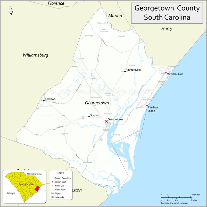
About Georgetown County Map, South Carolina: The map showing the county boundary, county seat, major cities, highways, water bodies and neighbouring counties.
Related South Carolina Links
Map of Georgetown County, South Carolina
Georgetown County is a county located in the U.S. state of South Carolina. It's county seat is Georgetown. As per 2020 census, the population of Georgetown County is 63921 people and population density is square miles. According to the United States Census Bureau, the county has a total area of 813.55 sq mi (2,107 km2). Georgetown County was established on 1769.
Georgetown County Facts
| Continent | North America |
| Country | United States |
| State | South Carolina |
| County Seat | Georgetown |
| Largest City/Town | Georgetown |
| Established | 1769 |
| Total Area | 1,031.52 sq mi (2,671.64 sq km) |
| Land Area | 813.91 sq mi (2,107.01 sq km) |
| Water Area | 217.61 sq mi (564.63 sq km) |
| Population | 61,684 (Census 2020) |
| Population Density | 75.8 people per sq mi |
| Time Zone | Eastern (EST) |
| Major Highways | US-17, US-521, US-701, SC-51, SC-261 |
| Major Rivers | Waccamaw River, Black River, Pee Dee River, Sampit River |
| Neighboring Counties | Horry, Williamsburg, Berkeley, Charleston |
| Famous For | Historic port, coastal scenery, rice plantations |
| Top Attractions | Huntington Beach State Park, Brookgreen Gardens, Historic Georgetown, Pawleys Island |
| Official Website | Official Website |
About Georgetown County, South Carolina
Georgetown County is located in the eastern coastal part of South Carolina in the United States and was established in 1769. The county seat is Georgetown, which is also the largest city. The county lies in the Lowcountry and Pee Dee regions and is known for its coastal landscapes, historic rice plantations, rivers, and one of the oldest ports in the state.
Cities and Towns in Georgetown County, South Carolina
| City/Town | Population (Census 2020) | Latitude & Longitude |
|---|---|---|
| Georgetown (county seat) | 8,403 | 33.3768N, 79.2945W |
| Andrews (partly) | 2,861 | 33.4516N, 79.5592W |
| Pawleys Island | 103 | 33.4291N, 79.1198W |
| Murrells Inlet (CDP) | 9,600+ | 33.5504N, 79.0414W |
| Garden City (CDP) | 9,200+ | 33.5924N, 79.0025W |
| DeBordieu Colony (CDP) | ~N/A | 33.3815N, 79.1940W |
| Sampit (CDP) | ~N/A | 33.3300N, 79.3500W |
Golf Courses in Georgetown County, South Carolina
| Golf Course | Location | Latitude & Longitude |
|---|---|---|
| Caledonia Golf & Fish Club | Pawleys Island | 33.4302N, 79.1420W |
| True Blue Golf Club | Pawleys Island | 33.4375N, 79.1498W |
| Heritage Club | Pawleys Island | 33.4240N, 79.1400W |
| International Club of Myrtle Beach | Murrells Inlet | 33.5678N, 79.1002W |
Roads and Highways in Georgetown County, South Carolina
The county is served by major highways that connect coastal communities and inland areas.
- US-17 - coastal highway running through Georgetown and along the shoreline
- US-521 - connects Georgetown to central South Carolina
- US-701 - links the county to inland regions
- SC-51 - connects to Florence and surrounding counties
- SC-261 - provides local access across the county
Neighboring Counties of Georgetown County
- Horry County (north)
- Williamsburg County (west)
- Berkeley County (southwest)
- Charleston County (south)
Top Attractions in Georgetown County, South Carolina
The county is known for its coastal beauty and historic sites.
- Huntington Beach State Park - beaches, wildlife, and Atalaya Castle
- Brookgreen Gardens - sculpture gardens and nature preserve
- Historic Georgetown - waterfront district and historic homes
- Pawleys Island - quiet beaches and vacation destination
- Waccamaw River - boating, fishing, and scenic views
- Rice Museum - history of rice plantations and culture
Distance from Georgetown County to Nearby Cities
- Georgetown to Myrtle Beach - 35 mi (56 km)
- Georgetown to Charleston - 60 mi (97 km)
- Georgetown to Florence - 60 mi (97 km)
- Georgetown to Columbia - 120 mi (193 km)
- Georgetown to Wilmington - 90 mi (145 km)
FAQs about Georgetown County
Georgetown County is located along the eastern coast of South Carolina in the Lowcountry region.
The population of Georgetown County is 61,684 according to the 2020 Census.
The county is known for its historic port, coastal scenery, and rice plantation history.
Major highways include US-17, US-521, US-701, SC-51, and SC-261.
Yes, Georgetown County has several golf courses, especially near Pawleys Island, including Caledonia Golf & Fish Club and True Blue Golf Club.
- Abbeville County Map
- Aiken County Map
- Allendale County Map
- Anderson County Map
- Bamberg County Map
- Barnwell County Map
- Beaufort County Map
- Berkeley County Map
- Calhoun County Map
- Charleston County Map
- Cherokee County Map
- Chester County Map
- Chesterfield County Map
- Clarendon County Map
- Colleton County Map
- Darlington County Map
- Dillon County Map
- Dorchester County Map
- Edgefield County Map
- Fairfield County Map
- Florence County Map
- Georgetown County Map
- Greenville County Map
- Greenwood County Map
- Hampton County Map
- Horry County Map
- Jasper County Map
- Kershaw County Map
- Lancaster County Map
- Laurens County Map
- Lee County Map
- Lexington County Map
- McCormick County Map
- Marion County Map
- Marlboro County Map
- Newberry County Map
- Oconee County Map
- Orangeburg County Map
- Pickens County Map
- Richland County Map
- Saluda County Map
- Spartanburg County Map
- Sumter County Map
- Union County Map
- Williamsburg County Map
- York County Map
- Alabama Counties
- Alaska boroughs
- Arizona Counties
- Arkansas Counties
- California County Map
- Colorado Counties
- Connecticut Counties
- Delaware Counties
- Florida County Map
- Georgia County Map
- Hawaii Counties
- Idaho Counties
- Illinois Counties
- Indiana Counties
- Iowa Counties
- Kansas Counties
- Kentucky Counties
- Louisiana Counties
- Maine Counties
- Maryland Counties
- Massachusetts Counties
- Michigan County Map
- Minnesota Counties
- Mississippi Counties
- Missouri Counties
- Montana Counties
- Nebraska Counties
- Nevada Counties
- New York Counties
- New Hampshire Counties
- New Jersey Counties
- New Mexico Counties
- North Carolina Counties
- North Dakota Counties
- Ohio County Map
- Oklahoma Counties
- Oregon Counties
- Pennsylvania Counties
- Rhode Island Counties
- South Carolina Counties
- South Dakota Counties
- Map of Tennessee
- Texas County Map
- Utah Counties
- Vermont Counties
- Virginia Counties
- Washington Counties
- West Virginia Counties
- Wisconsin Counties
- Wyoming Counties