Written and Fact-checked by Whereig Editors | Updated On: May 05, 2026 | 14:50 ET
Map of Calhoun County - Calhoun County is a county located in the U.S. state of South Carolina. Calhoun County Map showing cities, highways, important places and water bodies. Get Where is Calhoun County located in the map, major cities in Calhoun county, population, areas, and places of interest.
Map of Calhoun County, South Carolina
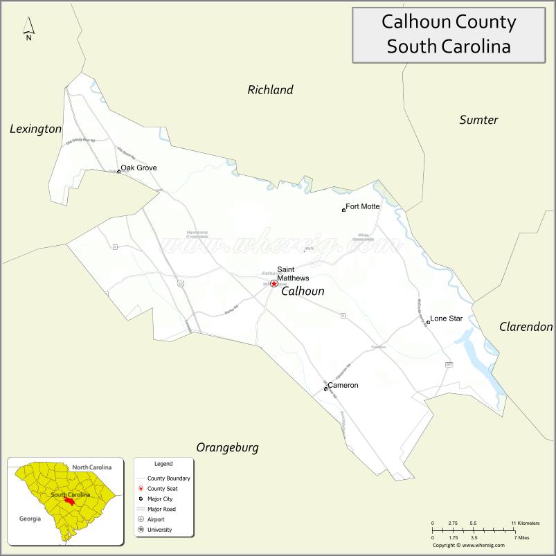
About Calhoun County Map, South Carolina: The map showing the county boundary, county seat, major cities, highways, water bodies and neighbouring counties.
Related South Carolina Links
Map of Calhoun County, South Carolina
Calhoun County is a county located in the U.S. state of South Carolina. It's county seat is St. Matthews. As per 2020 census, the population of Calhoun County is 14165 people and population density is square miles. According to the United States Census Bureau, the county has a total area of 392 sq mi (1,015 km2). Calhoun County was established on 1908.
Calhoun County Facts
| Continent | North America |
| Country | United States |
| State | South Carolina |
| County Seat | St. Matthews |
| Largest City/Town | St. Matthews |
| Established | 1908 |
| Total Area | 392.19 sq mi (1,015.77 sq km) |
| Land Area | 381.29 sq mi (987.54 sq km) |
| Water Area | 10.90 sq mi (28.23 sq km) |
| Population | 14,119 (Census 2020) |
| Population Density | 37.0 people per sq mi |
| Time Zone | Eastern (EST) |
| Major Highways | I-26, US-176, US-601, SC-6, SC-33 |
| Major Rivers | Congaree River, North Fork Edisto River |
| Neighboring Counties | Lexington, Richland, Orangeburg |
| Famous For | Congaree River floodplain, rural farmland, peach orchards |
| Top Attractions | Congaree National Park (nearby), Lake Marion access, St. Matthews historic district |
| Official Website | Official Website |
About Calhoun County, South Carolina
Calhoun County is located in the central part of South Carolina in the United States and was established in 1908. The county seat is St. Matthews, which is also the largest town. The county lies within the Midlands region and features flat terrain, agricultural land, and river systems that support farming and outdoor recreation.
Cities and Towns in Calhoun County, South Carolina
| City/Town | Population (Census 2020) | Latitude & Longitude |
|---|---|---|
| St. Matthews (county seat) | 2,017 | 33.6632N, 80.7779W |
| Cameron | 424 | 33.5554N, 80.7004W |
| Sandy Run | 324 | 33.6285N, 80.7184W |
| Lone Star (CDP) | 300+ | 33.6525N, 80.6543W |
Golf Courses in Calhoun County, South Carolina
| Golf Course | Location | Latitude & Longitude |
|---|---|---|
| Calhoun Hills Golf Complex | St. Matthews | 33.6552N, 80.7643W |
Roads and Highways in Calhoun County, South Carolina
The county is connected by major highways that provide access to Columbia and surrounding regions.
- I-26 - major interstate connecting Columbia and Charleston
- US-176 - runs parallel to I-26 through the county
- US-601 - connects St. Matthews to Orangeburg and Camden
- SC-6 - links rural communities and nearby counties
- SC-33 - provides local access within the county
Neighboring Counties of Calhoun County
- Richland County (north)
- Lexington County (northwest)
- Orangeburg County (south and east)
Top Attractions in Calhoun County, South Carolina
The county offers quiet rural charm with access to nearby natural attractions.
- Congaree National Park (nearby) - protected floodplain forest with trails and wildlife
- Lake Marion - popular for fishing and boating
- St. Matthews Historic District - historic buildings and local culture
- Calhoun County Museum - exhibits on local history
- Congaree River - scenic waterway for kayaking and nature viewing
- Local peach farms - seasonal fruit picking and agriculture tourism
Distance from Calhoun County to Nearby Cities
- St. Matthews to Columbia - 30 mi (48 km)
- St. Matthews to Orangeburg - 25 mi (40 km)
- St. Matthews to Charleston - 75 mi (121 km)
- St. Matthews to Sumter - 50 mi (80 km)
- St. Matthews to Augusta - 90 mi (145 km)
FAQs about Calhoun County
Calhoun County is located in the central Midlands region of South Carolina.
The population of Calhoun County is 14,119 according to the 2020 Census.
The county is known for its farmland, rivers, and proximity to Congaree National Park.
Major highways include I-26, US-176, US-601, SC-6, and SC-33.
Yes, Calhoun Hills Golf Complex is a known golf course in the county.
- Abbeville County Map
- Aiken County Map
- Allendale County Map
- Anderson County Map
- Bamberg County Map
- Barnwell County Map
- Beaufort County Map
- Berkeley County Map
- Calhoun County Map
- Charleston County Map
- Cherokee County Map
- Chester County Map
- Chesterfield County Map
- Clarendon County Map
- Colleton County Map
- Darlington County Map
- Dillon County Map
- Dorchester County Map
- Edgefield County Map
- Fairfield County Map
- Florence County Map
- Georgetown County Map
- Greenville County Map
- Greenwood County Map
- Hampton County Map
- Horry County Map
- Jasper County Map
- Kershaw County Map
- Lancaster County Map
- Laurens County Map
- Lee County Map
- Lexington County Map
- McCormick County Map
- Marion County Map
- Marlboro County Map
- Newberry County Map
- Oconee County Map
- Orangeburg County Map
- Pickens County Map
- Richland County Map
- Saluda County Map
- Spartanburg County Map
- Sumter County Map
- Union County Map
- Williamsburg County Map
- York County Map
- Alabama Counties
- Alaska boroughs
- Arizona Counties
- Arkansas Counties
- California County Map
- Colorado Counties
- Connecticut Counties
- Delaware Counties
- Florida County Map
- Georgia County Map
- Hawaii Counties
- Idaho Counties
- Illinois Counties
- Indiana Counties
- Iowa Counties
- Kansas Counties
- Kentucky Counties
- Louisiana Counties
- Maine Counties
- Maryland Counties
- Massachusetts Counties
- Michigan County Map
- Minnesota Counties
- Mississippi Counties
- Missouri Counties
- Montana Counties
- Nebraska Counties
- Nevada Counties
- New York Counties
- New Hampshire Counties
- New Jersey Counties
- New Mexico Counties
- North Carolina Counties
- North Dakota Counties
- Ohio County Map
- Oklahoma Counties
- Oregon Counties
- Pennsylvania Counties
- Rhode Island Counties
- South Carolina Counties
- South Dakota Counties
- Map of Tennessee
- Texas County Map
- Utah Counties
- Vermont Counties
- Virginia Counties
- Washington Counties
- West Virginia Counties
- Wisconsin Counties
- Wyoming Counties