Written and Fact-checked by Whereig Editors | Updated On: May 05, 2026 | 14:50 ET
Map of Kershaw County - Kershaw County is a county located in the U.S. state of South Carolina. Kershaw County Map showing cities, highways, important places and water bodies. Get Where is Kershaw County located in the map, major cities in Kershaw county, population, areas, and places of interest.
Map of Kershaw County, South Carolina
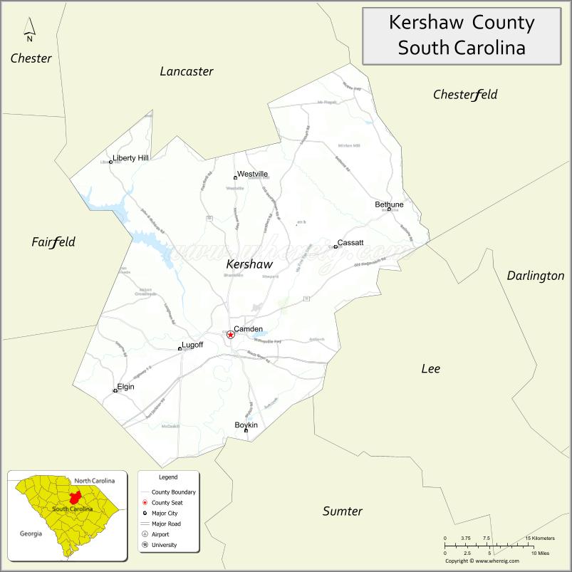
About Kershaw County Map, South Carolina: The map showing the county boundary, county seat, major cities, highways, water bodies and neighbouring counties.
Related South Carolina Links
Map of Kershaw County, South Carolina
Kershaw County is a county located in the U.S. state of South Carolina. It's county seat is Camden. As per 2020 census, the population of Kershaw County is 66130 people and population density is square miles. According to the United States Census Bureau, the county has a total area of 740 sq mi (1,917 km2). Kershaw County was established on 1798.
<Kershaw County Facts
| Continent | North America |
| Country | United States |
| State | South Carolina |
| County Seat | Camden |
| Largest City/Town | Camden |
| Established | 1791 |
| Total Area | 740.65 sq mi (1,918.27 sq km) |
| Land Area | 726.38 sq mi (1,881.31 sq km) |
| Water Area | 14.27 sq mi (36.96 sq km) |
| Population | 65,403 (Census 2020) |
| Population Density | 90.0 people per sq mi |
| Time Zone | Eastern (EST) |
| Major Highways | I-20, US-1, US-521, SC-34, SC-97 |
| Major Rivers | Wateree River, Lynches River |
| Neighboring Counties | Lancaster, Chesterfield, Darlington, Lee, Sumter, Richland, Fairfield |
| Famous For | Camden historic district, horse racing, Revolutionary War history |
| Top Attractions | Historic Camden Revolutionary War Site, Camden Archives and Museum, Lake Wateree |
| Official Website | Official Website |
About Kershaw County, South Carolina
Kershaw County is located in the central part of South Carolina in the United States and was established in 1791. The county seat is Camden, which is also the largest city. The county lies in the Midlands region and is known for its rich history, particularly its role in the American Revolutionary War, as well as its equestrian traditions and scenic river landscapes.
Cities and Towns in Kershaw County, South Carolina
| City/Town | Population (Census 2020) | Latitude & Longitude |
|---|---|---|
| Camden (county seat) | 7,196 | 34.2465N, 80.6070W |
| Lugoff | 8,000+ | 34.2279N, 80.6895W |
| Elgin | 1,818 | 34.1707N, 80.7945W |
| Bethune | 334 | 34.4146N, 80.3462W |
| Boykin | 100+ | 34.2290N, 80.6420W |
| Liberty Hill (CDP) | ~N/A | 34.3050N, 80.8700W |
| Cassatt (CDP) | ~N/A | 34.3010N, 80.4830W |
Golf Courses in Kershaw County, South Carolina
| Golf Course | Location | Latitude & Longitude |
|---|---|---|
| Camden Country Club | Camden | 34.2505N, 80.6120W |
| White Pines Golf Club | Camden | 34.2450N, 80.6200W |
Roads and Highways in Kershaw County, South Carolina
The county is well connected by highways that link it to Columbia and surrounding areas.
- I-20 - major interstate connecting Camden to Columbia and Florence
- US-1 - runs through Camden linking to Columbia and Cheraw
- US-521 - connects Camden to Lancaster and Sumter
- SC-34 - east-west route linking to Darlington and Newberry
- SC-97 - connects rural areas within the county
Neighboring Counties of Kershaw County
- Lancaster County (north)
- Chesterfield County (north)
- Darlington County (northeast)
- Lee County (east)
- Sumter County (south)
- Richland County (southwest)
- Fairfield County (west)
Top Attractions in Kershaw County, South Carolina
The county is rich in history and outdoor recreation opportunities.
- Historic Camden Revolutionary War Site - preserved battlefield and museum
- Camden Archives and Museum - exhibits on local history
- Lake Wateree - boating, fishing, and camping
- Goodale State Park - kayaking and nature trails
- Springdale Race Course - horse racing and equestrian events
- Wateree River - scenic outdoor recreation
Distance from Kershaw County to Nearby Cities
- Camden to Columbia - 35 mi (56 km)
- Camden to Charlotte - 90 mi (145 km)
- Camden to Florence - 65 mi (105 km)
- Camden to Charleston - 130 mi (209 km)
- Camden to Greenville - 110 mi (177 km)
FAQs about Kershaw County
Kershaw County is located in the central Midlands region of South Carolina.
The population of Kershaw County is 65,403 according to the 2020 Census.
The county is known for its Revolutionary War history, horse racing traditions, and scenic landscapes.
Major highways include I-20, US-1, US-521, SC-34, and SC-97.
Yes, Camden Country Club and White Pines Golf Club are located in the county.
- Abbeville County Map
- Aiken County Map
- Allendale County Map
- Anderson County Map
- Bamberg County Map
- Barnwell County Map
- Beaufort County Map
- Berkeley County Map
- Calhoun County Map
- Charleston County Map
- Cherokee County Map
- Chester County Map
- Chesterfield County Map
- Clarendon County Map
- Colleton County Map
- Darlington County Map
- Dillon County Map
- Dorchester County Map
- Edgefield County Map
- Fairfield County Map
- Florence County Map
- Georgetown County Map
- Greenville County Map
- Greenwood County Map
- Hampton County Map
- Horry County Map
- Jasper County Map
- Kershaw County Map
- Lancaster County Map
- Laurens County Map
- Lee County Map
- Lexington County Map
- McCormick County Map
- Marion County Map
- Marlboro County Map
- Newberry County Map
- Oconee County Map
- Orangeburg County Map
- Pickens County Map
- Richland County Map
- Saluda County Map
- Spartanburg County Map
- Sumter County Map
- Union County Map
- Williamsburg County Map
- York County Map
- Alabama Counties
- Alaska boroughs
- Arizona Counties
- Arkansas Counties
- California County Map
- Colorado Counties
- Connecticut Counties
- Delaware Counties
- Florida County Map
- Georgia County Map
- Hawaii Counties
- Idaho Counties
- Illinois Counties
- Indiana Counties
- Iowa Counties
- Kansas Counties
- Kentucky Counties
- Louisiana Counties
- Maine Counties
- Maryland Counties
- Massachusetts Counties
- Michigan County Map
- Minnesota Counties
- Mississippi Counties
- Missouri Counties
- Montana Counties
- Nebraska Counties
- Nevada Counties
- New York Counties
- New Hampshire Counties
- New Jersey Counties
- New Mexico Counties
- North Carolina Counties
- North Dakota Counties
- Ohio County Map
- Oklahoma Counties
- Oregon Counties
- Pennsylvania Counties
- Rhode Island Counties
- South Carolina Counties
- South Dakota Counties
- Map of Tennessee
- Texas County Map
- Utah Counties
- Vermont Counties
- Virginia Counties
- Washington Counties
- West Virginia Counties
- Wisconsin Counties
- Wyoming Counties