Written and Fact-checked by Whereig Editors | Updated On: May 05, 2026 | 14:50 ET
Map of Colleton County - Colleton County is a county located in the U.S. state of South Carolina. Colleton County Map showing cities, highways, important places and water bodies. Get Where is Colleton County located in the map, major cities in Colleton county, population, areas, and places of interest.
Map of Colleton County, South Carolina
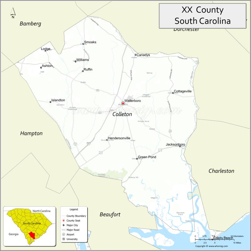
About Colleton County Map, South Carolina: The map showing the county boundary, county seat, major cities, highways, water bodies and neighbouring counties.
Related South Carolina Links
Map of Colleton County, South Carolina
Colleton County is a county located in the U.S. state of South Carolina. It's county seat is Walterboro. As per 2020 census, the population of Colleton County is 38462 people and population density is square miles. According to the United States Census Bureau, the county has a total area of 1,133 sq mi (2,934 km2). Colleton County was established on 1800.
Colleton County Facts
| Continent | North America |
| Country | United States |
| State | South Carolina |
| County Seat | Walterboro |
| Largest City/Town | Walterboro |
| Established | 1800 |
| Total Area | 1,132.48 sq mi (2,932.12 sq km) |
| Land Area | 1,056.79 sq mi (2,737.07 sq km) |
| Water Area | 75.69 sq mi (195.05 sq km) |
| Population | 38,604 (Census 2020) |
| Population Density | 36.5 people per sq mi |
| Time Zone | Eastern (EST) |
| Major Highways | I-95, US-17, US-21, SC-63, SC-64 |
| Major Rivers | Edisto River, Ashepoo River, Combahee River |
| Neighboring Counties | Charleston, Dorchester, Orangeburg, Bamberg, Hampton, Beaufort |
| Famous For | ACE Basin, wildlife, historic Walterboro |
| Top Attractions | ACE Basin, Colleton State Park, Walterboro Wildlife Sanctuary, Edisto River |
| Official Website | Official Website |
About Colleton County, South Carolina
Colleton County is located in the southeastern part of South Carolina in the United States and was established in 1800. The county seat is Walterboro, which is also the largest city. The county lies in the Lowcountry region and is known for its vast wetlands, rivers, and protected natural areas, including the nationally significant ACE Basin.
Cities and Towns in Colleton County, South Carolina
| City/Town | Population (Census 2020) | Latitude & Longitude |
|---|---|---|
| Walterboro (county seat) | 5,398 | 32.9052N, 80.6668W |
| Cottageville | 1,087 | 32.9563N, 80.4770W |
| Edisto Beach (partly) | 2,301 | 32.4974N, 80.3107W |
| Ridgeville (partly) | 2,109 | 33.0957N, 80.3143W |
| Smoaks | 215 | 33.0452N, 80.8068W |
| Williams | 67 | 33.0374N, 80.8326W |
| Lodge (CDP) | 120 | 33.0340N, 80.7920W |
| Green Pond (CDP) | ~N/A | 32.6070N, 80.5110W |
Golf Courses in Colleton County, South Carolina
| Golf Course | Location | Latitude & Longitude |
|---|---|---|
| The Plantation Course at Edisto | Edisto Beach | 32.5056N, 80.3158W |
| Dogwood Hills Golf Club | Walterboro | 32.9030N, 80.6705W |
Roads and Highways in Colleton County, South Carolina
The county is served by major highways that connect coastal and inland regions.
- I-95 - major north-south interstate passing through the county
- US-17 - coastal highway connecting Charleston and Savannah
- US-21 - connects Walterboro to Beaufort and surrounding areas
- SC-63 - links rural communities within the county
- SC-64 - connects Walterboro to Bamberg and surrounding counties
Neighboring Counties of Colleton County
- Charleston County (north)
- Dorchester County (north)
- Orangeburg County (northwest)
- Bamberg County (west)
- Hampton County (southwest)
- Beaufort County (south)
Top Attractions in Colleton County, South Carolina
The county is rich in natural beauty and wildlife-focused destinations.
- ACE Basin - one of the largest undeveloped estuaries on the East Coast
- Colleton State Park - camping, fishing, and river access
- Walterboro Wildlife Sanctuary - walking trails and wetlands
- Edisto River - canoeing, kayaking, and fishing
- Edisto Beach State Park - coastal views and recreation
- Great Swamp Sanctuary - scenic nature preserve
Distance from Colleton County to Nearby Cities
- Walterboro to Charleston - 50 mi (80 km)
- Walterboro to Savannah - 70 mi (113 km)
- Walterboro to Columbia - 90 mi (145 km)
- Walterboro to Beaufort - 60 mi (97 km)
- Walterboro to Augusta - 120 mi (193 km)
FAQs about Colleton County
Colleton County is located in the southeastern Lowcountry region of South Carolina.
The population of Colleton County is 38,604 according to the 2020 Census.
The county is known for the ACE Basin, wetlands, wildlife, and outdoor recreation.
Major highways include I-95, US-17, US-21, SC-63, and SC-64.
Yes, golf courses such as The Plantation Course at Edisto and Dogwood Hills Golf Club are located in the county.
- Abbeville County Map
- Aiken County Map
- Allendale County Map
- Anderson County Map
- Bamberg County Map
- Barnwell County Map
- Beaufort County Map
- Berkeley County Map
- Calhoun County Map
- Charleston County Map
- Cherokee County Map
- Chester County Map
- Chesterfield County Map
- Clarendon County Map
- Colleton County Map
- Darlington County Map
- Dillon County Map
- Dorchester County Map
- Edgefield County Map
- Fairfield County Map
- Florence County Map
- Georgetown County Map
- Greenville County Map
- Greenwood County Map
- Hampton County Map
- Horry County Map
- Jasper County Map
- Kershaw County Map
- Lancaster County Map
- Laurens County Map
- Lee County Map
- Lexington County Map
- McCormick County Map
- Marion County Map
- Marlboro County Map
- Newberry County Map
- Oconee County Map
- Orangeburg County Map
- Pickens County Map
- Richland County Map
- Saluda County Map
- Spartanburg County Map
- Sumter County Map
- Union County Map
- Williamsburg County Map
- York County Map
- Alabama Counties
- Alaska boroughs
- Arizona Counties
- Arkansas Counties
- California County Map
- Colorado Counties
- Connecticut Counties
- Delaware Counties
- Florida County Map
- Georgia County Map
- Hawaii Counties
- Idaho Counties
- Illinois Counties
- Indiana Counties
- Iowa Counties
- Kansas Counties
- Kentucky Counties
- Louisiana Counties
- Maine Counties
- Maryland Counties
- Massachusetts Counties
- Michigan County Map
- Minnesota Counties
- Mississippi Counties
- Missouri Counties
- Montana Counties
- Nebraska Counties
- Nevada Counties
- New York Counties
- New Hampshire Counties
- New Jersey Counties
- New Mexico Counties
- North Carolina Counties
- North Dakota Counties
- Ohio County Map
- Oklahoma Counties
- Oregon Counties
- Pennsylvania Counties
- Rhode Island Counties
- South Carolina Counties
- South Dakota Counties
- Map of Tennessee
- Texas County Map
- Utah Counties
- Vermont Counties
- Virginia Counties
- Washington Counties
- West Virginia Counties
- Wisconsin Counties
- Wyoming Counties