Written and Fact-checked by Whereig Editors | Updated On: May 05, 2026 | 14:50 ET
Map of Aiken County - Aiken County is a county located in the U.S. state of South Carolina. Aiken County Map showing cities, highways, important places and water bodies. Get Where is Aiken County located in the map, major cities in Aiken county, population, areas, and places of interest.
Map of Aiken County, South Carolina
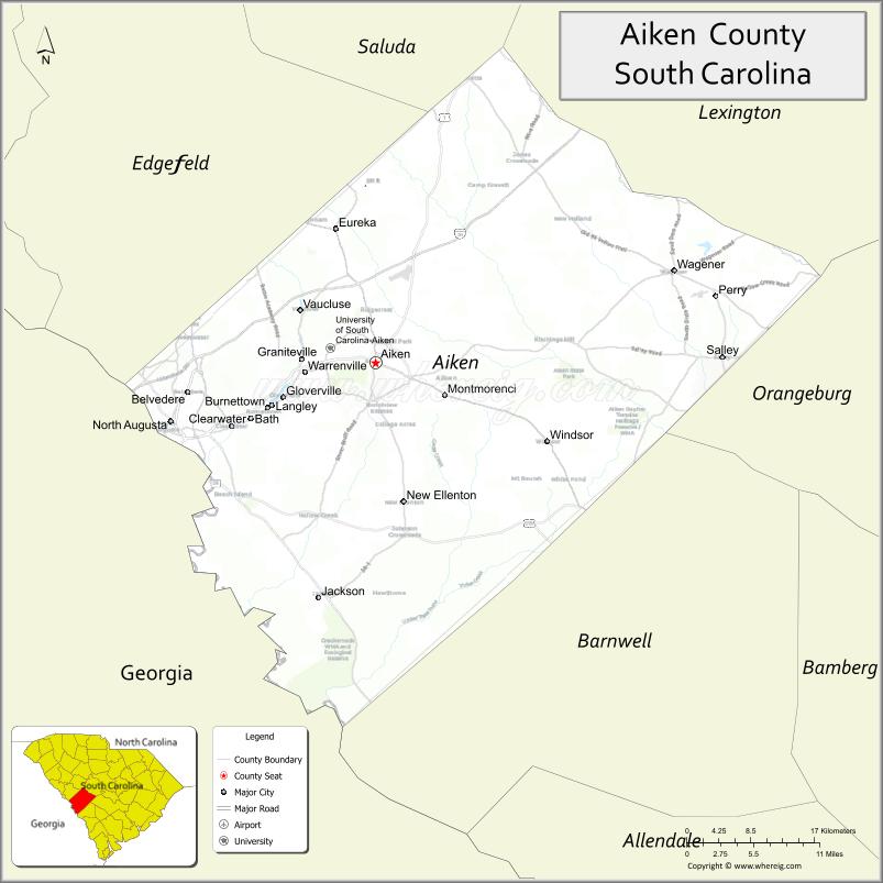
About Aiken County Map, South Carolina: The map showing the county boundary, county seat, major cities, highways, water bodies and neighbouring counties.
Related South Carolina Links
Map of Aiken County, South Carolina
Aiken County is a county located in the U.S. state of South Carolina. It's county seat is Aiken. As per 2020 census, the population of Aiken County is 170776 people and population density is square miles. According to the United States Census Bureau, the county has a total area of 1,080 sq mi (2,797 km2). Aiken County was established on 1871.
Aiken County Facts
| Continent | North America |
| Country | United States |
| State | South Carolina |
| County Seat | Aiken |
| Largest City/Town | Aiken |
| Established | 1871 |
| Total Area | 1,080.62 sq mi (2,798.79 sq km) |
| Land Area | 1,070.64 sq mi (2,772.98 sq km) |
| Water Area | 9.98 sq mi (25.84 sq km) |
| Population | 168,808 (Census 2020) |
| Population Density | 157.7 people per sq mi |
| Time Zone | Eastern (EST) |
| Major Highways | I-20, US-1, US-25, US-78, SC-19, SC-302 |
| Major Rivers | Savannah River, South Fork Edisto River |
| Neighboring Counties | Lexington, Saluda, Edgefield, Barnwell, Orangeburg, Richmond (GA), Columbia (GA) |
| Famous For | Horse culture, Savannah River Site, historic downtown Aiken |
| Top Attractions | Hopelands Gardens, Hitchcock Woods, Aiken Thoroughbred Racing Hall of Fame, Savannah River Site Museum |
| Official Website | Official Website |
About Aiken County, South Carolina
Aiken County is located in the western part of South Carolina in the United States and was established in 1871. The county seat is Aiken, which is also the largest city. The county lies along the Georgia border and is known for its equestrian heritage, rolling sandhills terrain, and its role in nuclear research at the Savannah River Site.
Cities and Towns in Aiken County, South Carolina
| City/Town | Population (Census 2020) | Latitude & Longitude |
|---|---|---|
| Aiken (county seat) | 31,516 | 33.5604N, 81.7196W |
| North Augusta | 24,064 | 33.5018N, 81.9651W |
| Burnettown | 2,763 | 33.5157N, 81.8496W |
| Clearwater | 4,370 | 33.5010N, 81.8907W |
| Gloverville | 2,781 | 33.5218N, 81.8315W |
| Graniteville | 3,059 | 33.5635N, 81.8104W |
| Jackson | 1,730 | 33.3285N, 81.7873W |
| Langley | 1,669 | 33.5179N, 81.8401W |
| Monetta (partly) | 236 | 33.8451N, 81.6023W |
| New Ellenton | 2,165 | 33.4226N, 81.6854W |
| Perry | 237 | 33.5707N, 81.3097W |
| Salley | 329 | 33.5585N, 81.3055W |
| Wagener | 631 | 33.6482N, 81.3659W |
| Windsor | 119 | 33.4743N, 81.5115W |
| Belvedere (CDP) | 5,792 | 33.5335N, 81.9446W |
| Bath (CDP) | 1,338 | 33.4988N, 81.8948W |
| Beech Island (CDP) | 8,023 | 33.4271N, 81.8798W |
| Edgefield Junction (CDP) | ~N/A | 33.6400N, 81.9000W |
Golf Courses in Aiken County, South Carolina
| Golf Course | Location | Latitude & Longitude |
|---|---|---|
| Palmetto Golf Club | Aiken | 33.5568N, 81.7142W |
| Aiken Golf Club | Aiken | 33.5551N, 81.7289W |
| Cedar Creek Golf Club | Aiken | 33.5152N, 81.7445W |
| Houndslake Country Club | Aiken | 33.5370N, 81.7054W |
| Mount Vintage Golf Club | North Augusta | 33.5803N, 81.9574W |
| The River Golf Club | North Augusta | 33.4972N, 81.9804W |
Roads and Highways in Aiken County, South Carolina
The county has strong transportation links connecting it to Georgia and central South Carolina.
- I-20 - major east-west interstate connecting Augusta and Columbia
- US-1 - runs through Aiken and connects to Augusta and Columbia
- US-25 - links North Augusta to Augusta, GA and Greenville
- US-78 - crosses southern parts of the county
- SC-19 - connects Aiken to Edgefield and surrounding areas
- SC-302 - serves North Augusta and connects to I-20
Neighboring Counties of Aiken County
- Saluda County (north)
- Lexington County (northeast)
- Orangeburg County (east)
- Barnwell County (south)
- Edgefield County (northwest)
- Richmond County, Georgia (west)
- Columbia County, Georgia (northwest)
Top Attractions in Aiken County, South Carolina
Aiken County offers a rich mix of nature, history, and equestrian culture.
- Hopelands Gardens - beautiful landscaped gardens in Aiken
- Hitchcock Woods - one of the largest urban forests in the U.S.
- Aiken Thoroughbred Racing Hall of Fame - celebrates horse racing history
- Savannah River Site Museum - showcases nuclear research history
- Citizens Park - family-friendly park with trails and sports facilities
- Redcliffe Plantation State Historic Site - historic plantation home
- Augusta Canal National Heritage Area (nearby access) - scenic canal trails
- Langley Pond Park - popular spot for fishing and recreation
Distance from Aiken County to Nearby Cities
- Aiken to Augusta - 20 mi (32 km)
- Aiken to Columbia - 60 mi (97 km)
- Aiken to Greenville - 110 mi (177 km)
- Aiken to Charleston - 130 mi (209 km)
- Aiken to Atlanta - 150 mi (241 km)
FAQs about Aiken County
Aiken County is located in western South Carolina along the Georgia border.
The population of Aiken County is 168,808 according to the 2020 Census.
Aiken County is known for its horse culture, historic downtown, and the Savannah River Site.
Major highways include I-20, US-1, US-25, US-78, SC-19, and SC-302.
Yes, Aiken County has several golf courses including Palmetto Golf Club, Aiken Golf Club, and Cedar Creek Golf Club.
- Abbeville County Map
- Aiken County Map
- Allendale County Map
- Anderson County Map
- Bamberg County Map
- Barnwell County Map
- Beaufort County Map
- Berkeley County Map
- Calhoun County Map
- Charleston County Map
- Cherokee County Map
- Chester County Map
- Chesterfield County Map
- Clarendon County Map
- Colleton County Map
- Darlington County Map
- Dillon County Map
- Dorchester County Map
- Edgefield County Map
- Fairfield County Map
- Florence County Map
- Georgetown County Map
- Greenville County Map
- Greenwood County Map
- Hampton County Map
- Horry County Map
- Jasper County Map
- Kershaw County Map
- Lancaster County Map
- Laurens County Map
- Lee County Map
- Lexington County Map
- McCormick County Map
- Marion County Map
- Marlboro County Map
- Newberry County Map
- Oconee County Map
- Orangeburg County Map
- Pickens County Map
- Richland County Map
- Saluda County Map
- Spartanburg County Map
- Sumter County Map
- Union County Map
- Williamsburg County Map
- York County Map
- Alabama Counties
- Alaska boroughs
- Arizona Counties
- Arkansas Counties
- California County Map
- Colorado Counties
- Connecticut Counties
- Delaware Counties
- Florida County Map
- Georgia County Map
- Hawaii Counties
- Idaho Counties
- Illinois Counties
- Indiana Counties
- Iowa Counties
- Kansas Counties
- Kentucky Counties
- Louisiana Counties
- Maine Counties
- Maryland Counties
- Massachusetts Counties
- Michigan County Map
- Minnesota Counties
- Mississippi Counties
- Missouri Counties
- Montana Counties
- Nebraska Counties
- Nevada Counties
- New York Counties
- New Hampshire Counties
- New Jersey Counties
- New Mexico Counties
- North Carolina Counties
- North Dakota Counties
- Ohio County Map
- Oklahoma Counties
- Oregon Counties
- Pennsylvania Counties
- Rhode Island Counties
- South Carolina Counties
- South Dakota Counties
- Map of Tennessee
- Texas County Map
- Utah Counties
- Vermont Counties
- Virginia Counties
- Washington Counties
- West Virginia Counties
- Wisconsin Counties
- Wyoming Counties