Written and Fact-checked by Whereig Editors | Updated On: May 05, 2026 | 14:50 ET
Map of Spartanburg County - Spartanburg County is a county located in the U.S. state of South Carolina. Spartanburg County Map showing cities, highways, important places and water bodies. Get Where is Spartanburg County located in the map, major cities in Spartanburg county, population, areas, and places of interest.
Map of Spartanburg County, South Carolina
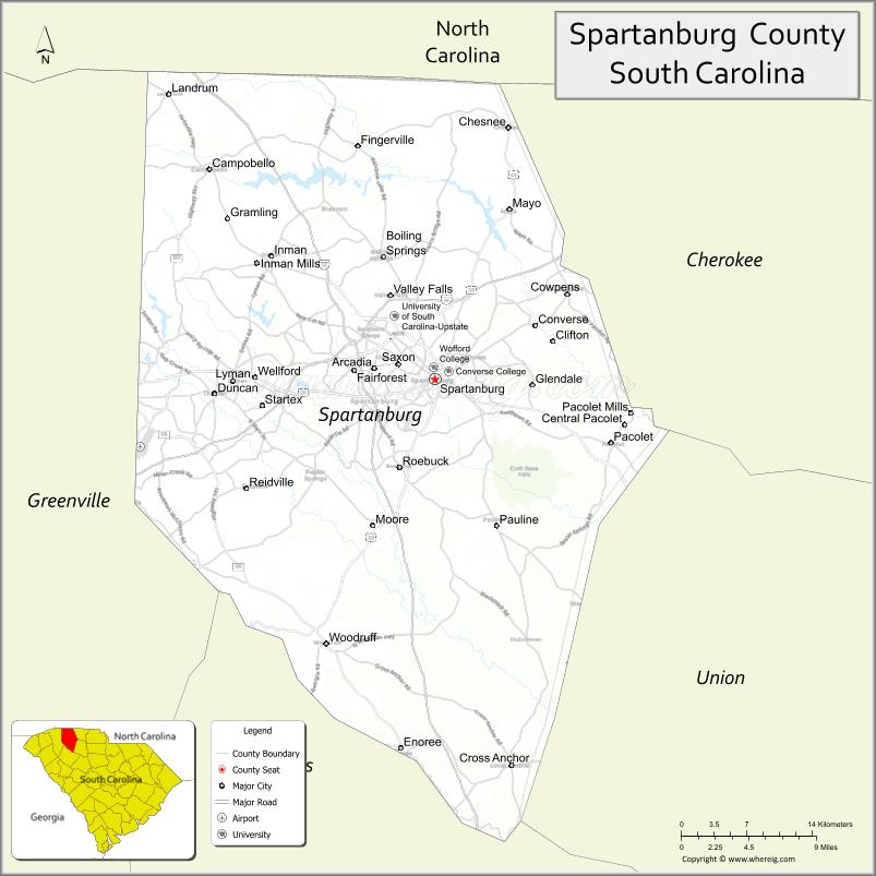
About Spartanburg County Map, South Carolina: The map showing the county boundary, county seat, major cities, highways, water bodies and neighbouring counties.
Related South Carolina Links
Map of Spartanburg County, South Carolina
Spartanburg County is a county located in the U.S. state of South Carolina. It's county seat is Spartanburg. As per 2020 census, the population of Spartanburg County is 335864 people and population density is square miles. According to the United States Census Bureau, the county has a total area of 819 sq mi (2,121 km2). Spartanburg County was established on 1785.
Spartanburg County Facts
| Continent | North America |
| Country | United States |
| State | South Carolina |
| County Seat | Spartanburg |
| Largest City/Town | Spartanburg |
| Established | 1785 |
| Total Area | 819.28 sq mi (2,121.88 sq km) |
| Land Area | 808.66 sq mi (2,094.42 sq km) |
| Water Area | 10.62 sq mi (27.46 sq km) |
| Population | 327,997 (Census 2020) |
| Population Density | 405.6 people per sq mi |
| Time Zone | Eastern (EST) |
| Major Highways | I-26, I-85, I-585, US-29, US-176, US-221 |
| Major Rivers | Broad River, Pacolet River, Tyger River |
| Neighboring Counties | Cherokee, Union, Laurens, Greenville, Polk (NC), Rutherford (NC) |
| Famous For | BMW manufacturing plant, higher education, historic sites |
| Top Attractions | BMW Zentrum, Hatcher Garden, Croft State Park, Spartanburg Regional History Museum |
| Official Website | Official Website |
About Spartanburg County, South Carolina
Spartanburg County is located in the northwestern part of South Carolina in the United States and was established in 1785. The county seat and largest city is Spartanburg. The county lies in the Upstate region and is known for its strong manufacturing sector, including the BMW plant, as well as its educational institutions and historic significance.
Cities and Towns in Spartanburg County, South Carolina
| City/Town | Population (Census 2020) | Latitude & Longitude |
|---|---|---|
| Spartanburg (county seat) | 38,401 | 34.9496N, 81.9320W |
| Greer (partly) | 35,000+ | 34.9387N, 82.2271W |
| Duncan | 3,200+ | 34.9376N, 82.1354W |
| Woodruff | 4,300+ | 34.7398N, 82.0351W |
| Inman | 2,400+ | 35.0473N, 82.0901W |
| Lyman | 3,200+ | 34.9493N, 82.1276W |
| Chesnee | 900 | 35.1476N, 81.8612W |
| Wellford | 2,500+ | 34.9507N, 82.1076W |
| Landrum | 2,300+ | 35.1765N, 82.1893W |
| Boiling Springs (CDP) | 10,000+ | 35.0465N, 81.9812W |
Golf Courses in Spartanburg County, South Carolina
| Golf Course | Location | Latitude & Longitude |
|---|---|---|
| Carolina Country Club | Spartanburg | 34.9500N, 81.9400W |
| Woodfin Ridge Golf Club | Inman | 35.0500N, 82.0700W |
| River Falls Plantation Golf Course | Duncan | 34.9300N, 82.1400W |
| Village Greens Golf Club | Inman | 35.0400N, 82.0800W |
Roads and Highways in Spartanburg County, South Carolina
The county is a major transportation hub in the Upstate region.
- I-85 - major interstate connecting Atlanta and Charlotte
- I-26 - connects Spartanburg to Asheville and Columbia
- I-585 - spur connecting I-85 to downtown Spartanburg
- US-29, US-176, US-221 - key routes across the county
Neighboring Counties of Spartanburg County
- Cherokee County (east)
- Union County (south)
- Laurens County (southwest)
- Greenville County (west)
- Polk County, North Carolina (north)
- Rutherford County, North Carolina (north)
Top Attractions in Spartanburg County, South Carolina
The county offers cultural, historical, and outdoor attractions.
- BMW Zentrum - visitor center showcasing BMW manufacturing
- Croft State Park - hiking, biking, and horseback riding
- Hatcher Garden and Woodland Preserve - botanical garden and trails
- Spartanburg Regional History Museum - local history exhibits
- Chapman Cultural Center - arts and cultural events
- Tyger River Park - sports and outdoor recreation
Distance from Spartanburg County to Nearby Cities
- Spartanburg to Greenville - 30 mi (48 km)
- Spartanburg to Charlotte - 75 mi (121 km)
- Spartanburg to Asheville - 70 mi (113 km)
- Spartanburg to Columbia - 95 mi (153 km)
- Spartanburg to Atlanta - 180 mi (290 km)
FAQs about Spartanburg County
Spartanburg County is located in the northwestern Upstate region of South Carolina.
The population of Spartanburg County is 327,997 according to the 2020 Census.
The county is known for its manufacturing industry, including BMW, and its educational institutions.
Major highways include I-85, I-26, I-585, US-29, US-176, and US-221.
Yes, golf courses such as Woodfin Ridge Golf Club and River Falls Plantation Golf Course are located in the county.
- Abbeville County Map
- Aiken County Map
- Allendale County Map
- Anderson County Map
- Bamberg County Map
- Barnwell County Map
- Beaufort County Map
- Berkeley County Map
- Calhoun County Map
- Charleston County Map
- Cherokee County Map
- Chester County Map
- Chesterfield County Map
- Clarendon County Map
- Colleton County Map
- Darlington County Map
- Dillon County Map
- Dorchester County Map
- Edgefield County Map
- Fairfield County Map
- Florence County Map
- Georgetown County Map
- Greenville County Map
- Greenwood County Map
- Hampton County Map
- Horry County Map
- Jasper County Map
- Kershaw County Map
- Lancaster County Map
- Laurens County Map
- Lee County Map
- Lexington County Map
- McCormick County Map
- Marion County Map
- Marlboro County Map
- Newberry County Map
- Oconee County Map
- Orangeburg County Map
- Pickens County Map
- Richland County Map
- Saluda County Map
- Spartanburg County Map
- Sumter County Map
- Union County Map
- Williamsburg County Map
- York County Map
- Alabama Counties
- Alaska boroughs
- Arizona Counties
- Arkansas Counties
- California County Map
- Colorado Counties
- Connecticut Counties
- Delaware Counties
- Florida County Map
- Georgia County Map
- Hawaii Counties
- Idaho Counties
- Illinois Counties
- Indiana Counties
- Iowa Counties
- Kansas Counties
- Kentucky Counties
- Louisiana Counties
- Maine Counties
- Maryland Counties
- Massachusetts Counties
- Michigan County Map
- Minnesota Counties
- Mississippi Counties
- Missouri Counties
- Montana Counties
- Nebraska Counties
- Nevada Counties
- New York Counties
- New Hampshire Counties
- New Jersey Counties
- New Mexico Counties
- North Carolina Counties
- North Dakota Counties
- Ohio County Map
- Oklahoma Counties
- Oregon Counties
- Pennsylvania Counties
- Rhode Island Counties
- South Carolina Counties
- South Dakota Counties
- Map of Tennessee
- Texas County Map
- Utah Counties
- Vermont Counties
- Virginia Counties
- Washington Counties
- West Virginia Counties
- Wisconsin Counties
- Wyoming Counties