Written and Fact-checked by Whereig Editors | Updated On: May 05, 2026 | 14:50 ET
Map of Anderson County - Anderson County is a county located in the U.S. state of South Carolina. Anderson County Map showing cities, highways, important places and water bodies. Get Where is Anderson County located in the map, major cities in Anderson county, population, areas, and places of interest.
Map of Anderson County, South Carolina
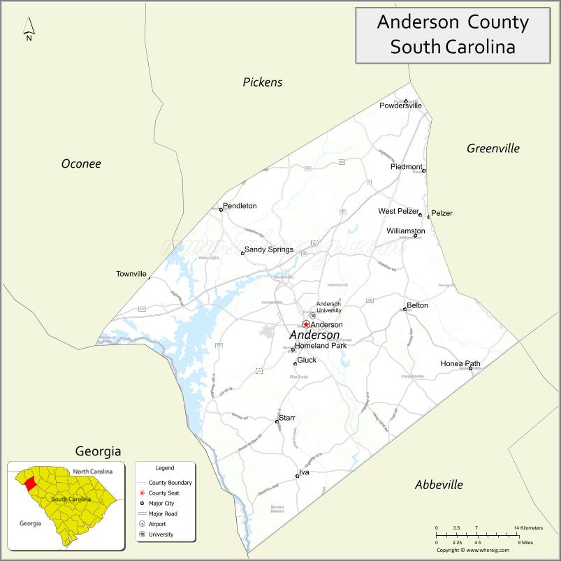
About Anderson County Map, South Carolina: The map showing the county boundary, county seat, major cities, highways, water bodies and neighbouring counties.
Related South Carolina Links
Map of Anderson County, South Carolina
Anderson County is a county located in the U.S. state of South Carolina. It's county seat is Anderson. As per 2020 census, the population of Anderson County is 206908 people and population density is square miles. According to the United States Census Bureau, the county has a total area of 757 sq mi (1,961 km2). Anderson County was established on 1826.
Anderson County Facts
| Continent | North America |
| Country | United States |
| State | South Carolina |
| County Seat | Anderson |
| Largest City/Town | Anderson |
| Established | 1826 |
| Total Area | 757.85 sq mi (1,962.82 sq km) |
| Land Area | 715.21 sq mi (1,852.44 sq km) |
| Water Area | 42.64 sq mi (110.38 sq km) |
| Population | 203,718 (Census 2020) |
| Population Density | 284.9 people per sq mi |
| Time Zone | Eastern (EST) |
| Major Highways | I-85, US-29, US-76, US-178, SC-24, SC-81 |
| Major Rivers | Seneca River, Savannah River |
| Neighboring Counties | Greenville, Pickens, Oconee, Abbeville, Laurens |
| Famous For | Lake Hartwell, manufacturing, Anderson University |
| Top Attractions | Lake Hartwell, Sadlers Creek State Park, Downtown Anderson, Denver Downs Farm |
| Official Website | Official Website |
About Anderson County, South Carolina
Anderson County is located in the northwestern part of South Carolina in the United States and was established in 1826. The county seat is Anderson, which is also the largest city. The county lies in the Upstate region and features a mix of urban growth, farmland, and scenic lakes, especially around Lake Hartwell, making it a key economic and recreational area.
Cities and Towns in Anderson County, South Carolina
| City/Town | Population (Census 2020) | Latitude & Longitude |
|---|---|---|
| Anderson (county seat) | 28,296 | 34.5034N, 82.6501W |
| Belton | 4,484 | 34.5229N, 82.4948W |
| Calhoun Falls (partly) | 2,049 | 34.0929N, 82.5946W |
| Clemson (partly) | 17,681 | 34.6834N, 82.8374W |
| Honea Path (partly) | 3,739 | 34.4462N, 82.3915W |
| Iva | 1,406 | 34.3065N, 82.6626W |
| Pendleton | 3,431 | 34.6512N, 82.7838W |
| Starr | 173 | 34.3776N, 82.6937W |
| West Pelzer | 880 | 34.6451N, 82.4756W |
| Williamston | 4,156 | 34.6187N, 82.4773W |
| Pelzer | 1,269 | 34.6456N, 82.4604W |
| Powdersville (CDP) | 9,803 | 34.7884N, 82.4926W |
| Piedmont (CDP, partly) | 5,723 | 34.7023N, 82.4646W |
| Centerville (CDP) | 7,000+ | 34.5301N, 82.7096W |
| Homeland Park (CDP) | 6,000+ | 34.4704N, 82.6512W |
| Northlake (CDP) | 3,000+ | 34.5705N, 82.6708W |
Golf Courses in Anderson County, South Carolina
| Golf Course | Location | Latitude & Longitude |
|---|---|---|
| Cobb�s Glen Country Club | Anderson | 34.5485N, 82.6847W |
| Brookstone Meadows Golf Club | Anderson | 34.5538N, 82.6251W |
| Pendleton Golf Club | Pendleton | 34.6508N, 82.7829W |
| Stone Creek Cove Golf Club | Anderson | 34.5023N, 82.8254W |
| Links at Stoney Point (nearby access) | Lake Hartwell area | 34.4500N, 82.8500W |
Roads and Highways in Anderson County, South Carolina
The county has strong transportation infrastructure connecting it to major Upstate cities.
- I-85 - major interstate connecting Atlanta and Charlotte
- US-29 - runs parallel to I-85 and connects local towns
- US-76 - connects Anderson to Clemson and further west
- US-178 - links southern parts of the county
- SC-24 - connects Anderson to Lake Hartwell areas
- SC-81 - major local route through Anderson
Neighboring Counties of Anderson County
- Greenville County (north)
- Pickens County (northwest)
- Oconee County (west)
- Abbeville County (south)
- Laurens County (east)
Top Attractions in Anderson County, South Carolina
The county offers a mix of lakes, parks, and cultural attractions.
- Lake Hartwell - major reservoir for boating and fishing
- Sadlers Creek State Park - camping and lakeside recreation
- Downtown Anderson - shops, restaurants, and historic buildings
- Denver Downs Farm - seasonal festivals and family activities
- Pendleton Historic District - preserved historic town charm
- Carolina Wren Park - community events and outdoor space
- Broadway Lake - popular local recreation spot
- Anderson Sports & Entertainment Center - events and sports venue
Distance from Anderson County to Nearby Cities
- Anderson to Greenville - 30 mi (48 km)
- Anderson to Clemson - 15 mi (24 km)
- Anderson to Columbia - 130 mi (209 km)
- Anderson to Atlanta - 110 mi (177 km)
- Anderson to Charlotte - 130 mi (209 km)
FAQs about Anderson County
Anderson County is located in the northwestern part of South Carolina in the Upstate region.
The population of Anderson County is 203,718 according to the 2020 Census.
It is known for Lake Hartwell, manufacturing, and Anderson University.
Major highways include I-85, US-29, US-76, US-178, SC-24, and SC-81.
Yes, there are several golf courses including Cobb�s Glen Country Club and Brookstone Meadows Golf Club.
- Abbeville County Map
- Aiken County Map
- Allendale County Map
- Anderson County Map
- Bamberg County Map
- Barnwell County Map
- Beaufort County Map
- Berkeley County Map
- Calhoun County Map
- Charleston County Map
- Cherokee County Map
- Chester County Map
- Chesterfield County Map
- Clarendon County Map
- Colleton County Map
- Darlington County Map
- Dillon County Map
- Dorchester County Map
- Edgefield County Map
- Fairfield County Map
- Florence County Map
- Georgetown County Map
- Greenville County Map
- Greenwood County Map
- Hampton County Map
- Horry County Map
- Jasper County Map
- Kershaw County Map
- Lancaster County Map
- Laurens County Map
- Lee County Map
- Lexington County Map
- McCormick County Map
- Marion County Map
- Marlboro County Map
- Newberry County Map
- Oconee County Map
- Orangeburg County Map
- Pickens County Map
- Richland County Map
- Saluda County Map
- Spartanburg County Map
- Sumter County Map
- Union County Map
- Williamsburg County Map
- York County Map
- Alabama Counties
- Alaska boroughs
- Arizona Counties
- Arkansas Counties
- California County Map
- Colorado Counties
- Connecticut Counties
- Delaware Counties
- Florida County Map
- Georgia County Map
- Hawaii Counties
- Idaho Counties
- Illinois Counties
- Indiana Counties
- Iowa Counties
- Kansas Counties
- Kentucky Counties
- Louisiana Counties
- Maine Counties
- Maryland Counties
- Massachusetts Counties
- Michigan County Map
- Minnesota Counties
- Mississippi Counties
- Missouri Counties
- Montana Counties
- Nebraska Counties
- Nevada Counties
- New York Counties
- New Hampshire Counties
- New Jersey Counties
- New Mexico Counties
- North Carolina Counties
- North Dakota Counties
- Ohio County Map
- Oklahoma Counties
- Oregon Counties
- Pennsylvania Counties
- Rhode Island Counties
- South Carolina Counties
- South Dakota Counties
- Map of Tennessee
- Texas County Map
- Utah Counties
- Vermont Counties
- Virginia Counties
- Washington Counties
- West Virginia Counties
- Wisconsin Counties
- Wyoming Counties