Written and Fact-checked by Whereig Editors | Updated On: May 05, 2026 | 14:50 ET
Map of Jasper County - Jasper County is a county located in the U.S. state of South Carolina. Jasper County Map showing cities, highways, important places and water bodies. Get Where is Jasper County located in the map, major cities in Jasper county, population, areas, and places of interest.
Map of Jasper County, South Carolina
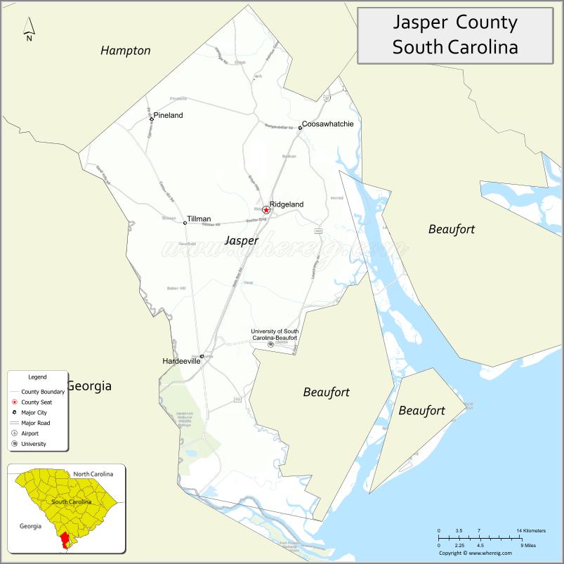
About Jasper County Map, South Carolina: The map showing the county boundary, county seat, major cities, highways, water bodies and neighbouring counties.
Related South Carolina Links
Map of Jasper County, South Carolina
Jasper County is a county located in the U.S. state of South Carolina. It's county seat is Ridgeland. As per 2020 census, the population of Jasper County is 30324 people and population density is square miles. According to the United States Census Bureau, the county has a total area of 700 sq mi (1,813 km2). Jasper County was established on 1912.
Jasper County Facts
| Continent | North America |
| Country | United States |
| State | South Carolina |
| County Seat | Ridgeland |
| Largest City/Town | Hardeeville |
| Established | 1912 |
| Total Area | 655.25 sq mi (1,696.10 sq km) |
| Land Area | 640.64 sq mi (1,658.24 sq km) |
| Water Area | 14.61 sq mi (37.86 sq km) |
| Population | 29,781 (Census 2020) |
| Population Density | 46.5 people per sq mi |
| Time Zone | Eastern (EST) |
| Major Highways | I-95, US-17, US-278, SC-336 |
| Major Rivers | Savannah River, Coosawhatchie River |
| Neighboring Counties | Beaufort, Hampton, Allendale, Effingham (GA), Chatham (GA) |
| Famous For | Proximity to Savannah, Lowcountry landscapes, growing communities |
| Top Attractions | Savannah National Wildlife Refuge, Sergeant Jasper Park, Blue Heron Nature Center |
| Official Website | Official Website |
About Jasper County, South Carolina
Jasper County is located in the southern part of South Carolina in the United States and was established in 1912. The county seat is Ridgeland, while the largest city is Hardeeville. The county lies in the Lowcountry region along the Georgia border and is known for its natural landscapes, proximity to Savannah, and rapid development in residential and commercial areas.
Cities and Towns in Jasper County, South Carolina
| City/Town | Population (Census 2020) | Latitude & Longitude |
|---|---|---|
| Hardeeville | 7,473 | 32.2871N, 81.0807W |
| Ridgeland (county seat) | 4,036 | 32.4802N, 80.9845W |
| Grahamville (CDP) | ~N/A | 32.4500N, 80.9700W |
| Pineland (CDP) | ~N/A | 32.5900N, 81.0800W |
| Coosawhatchie (CDP) | ~N/A | 32.5300N, 80.9300W |
Golf Courses in Jasper County, South Carolina
| Golf Course | Location | Latitude & Longitude |
|---|---|---|
| Hilton Head Lakes Golf Club | Hardeeville | 32.3105N, 81.0208W |
| Purrysburg Golf Club | Hardeeville area | 32.2700N, 81.0500W |
Roads and Highways in Jasper County, South Carolina
The county is well connected by major highways that support regional travel and economic growth.
- I-95 - major north-south interstate running through the county
- US-17 - connects Jasper County to coastal regions
- US-278 - links the county to Hilton Head Island and Savannah
- SC-336 - connects local communities within the county
Neighboring Counties of Jasper County
- Beaufort County (east)
- Hampton County (north)
- Allendale County (northwest)
- Effingham County, Georgia (west)
- Chatham County, Georgia (south)
Top Attractions in Jasper County, South Carolina
The county features natural attractions and access to nearby coastal destinations.
- Savannah National Wildlife Refuge - wildlife viewing and scenic landscapes
- Sergeant Jasper Park - camping, fishing, and outdoor recreation
- Blue Heron Nature Center - trails and educational exhibits
- Coosawhatchie River - kayaking and fishing
- Hardeeville Speedway - local racing events
- Nearby Savannah, Georgia - historic city and tourism destination
Distance from Jasper County to Nearby Cities
- Ridgeland to Savannah - 20 mi (32 km)
- Ridgeland to Beaufort - 35 mi (56 km)
- Ridgeland to Hilton Head Island - 30 mi (48 km)
- Ridgeland to Charleston - 90 mi (145 km)
- Ridgeland to Columbia - 110 mi (177 km)
FAQs about Jasper County
Jasper County is located in the southern Lowcountry region of South Carolina along the Georgia border.
The population of Jasper County is 29,781 according to the 2020 Census.
The county is known for its natural landscapes, proximity to Savannah, and growing communities.
Major highways include I-95, US-17, US-278, and SC-336.
Yes, golf courses such as Hilton Head Lakes Golf Club are located in the county.
- Abbeville County Map
- Aiken County Map
- Allendale County Map
- Anderson County Map
- Bamberg County Map
- Barnwell County Map
- Beaufort County Map
- Berkeley County Map
- Calhoun County Map
- Charleston County Map
- Cherokee County Map
- Chester County Map
- Chesterfield County Map
- Clarendon County Map
- Colleton County Map
- Darlington County Map
- Dillon County Map
- Dorchester County Map
- Edgefield County Map
- Fairfield County Map
- Florence County Map
- Georgetown County Map
- Greenville County Map
- Greenwood County Map
- Hampton County Map
- Horry County Map
- Jasper County Map
- Kershaw County Map
- Lancaster County Map
- Laurens County Map
- Lee County Map
- Lexington County Map
- McCormick County Map
- Marion County Map
- Marlboro County Map
- Newberry County Map
- Oconee County Map
- Orangeburg County Map
- Pickens County Map
- Richland County Map
- Saluda County Map
- Spartanburg County Map
- Sumter County Map
- Union County Map
- Williamsburg County Map
- York County Map
- Alabama Counties
- Alaska boroughs
- Arizona Counties
- Arkansas Counties
- California County Map
- Colorado Counties
- Connecticut Counties
- Delaware Counties
- Florida County Map
- Georgia County Map
- Hawaii Counties
- Idaho Counties
- Illinois Counties
- Indiana Counties
- Iowa Counties
- Kansas Counties
- Kentucky Counties
- Louisiana Counties
- Maine Counties
- Maryland Counties
- Massachusetts Counties
- Michigan County Map
- Minnesota Counties
- Mississippi Counties
- Missouri Counties
- Montana Counties
- Nebraska Counties
- Nevada Counties
- New York Counties
- New Hampshire Counties
- New Jersey Counties
- New Mexico Counties
- North Carolina Counties
- North Dakota Counties
- Ohio County Map
- Oklahoma Counties
- Oregon Counties
- Pennsylvania Counties
- Rhode Island Counties
- South Carolina Counties
- South Dakota Counties
- Map of Tennessee
- Texas County Map
- Utah Counties
- Vermont Counties
- Virginia Counties
- Washington Counties
- West Virginia Counties
- Wisconsin Counties
- Wyoming Counties