Written and Fact-checked by Whereig Editors | Updated On: May 05, 2026 | 14:50 ET
Map of Cherokee County - Cherokee County is a county located in the U.S. state of South Carolina. Cherokee County Map showing cities, highways, important places and water bodies. Get Where is Cherokee County located in the map, major cities in Cherokee county, population, areas, and places of interest.
Map of Cherokee County, South Carolina
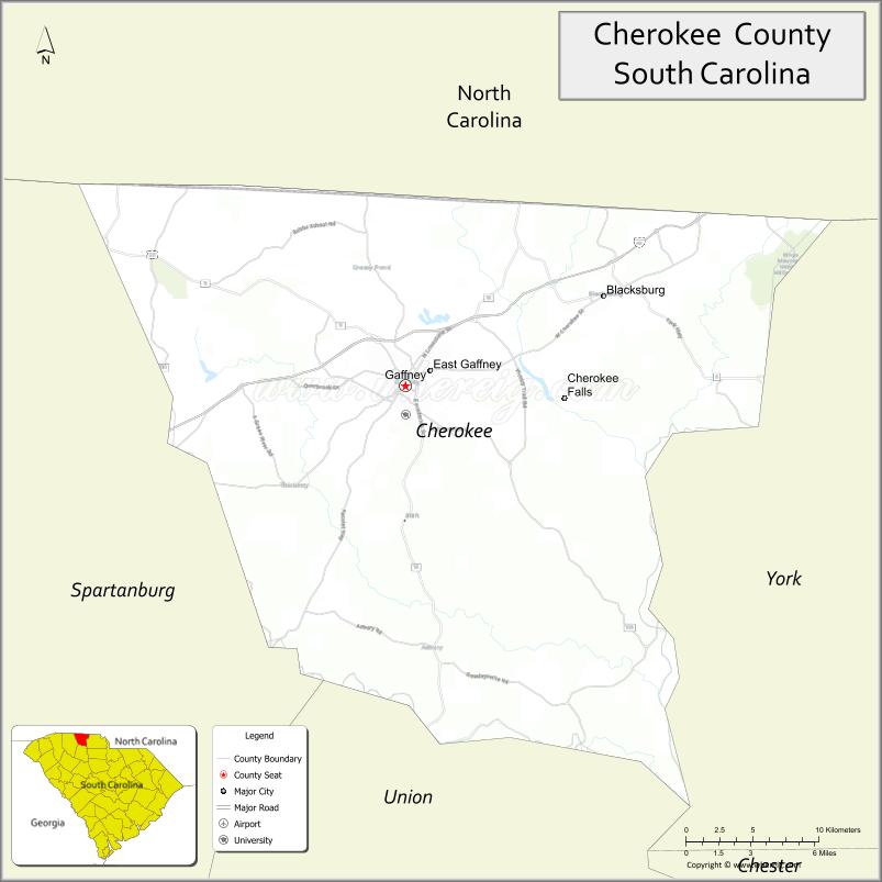
About Cherokee County Map, South Carolina: The map showing the county boundary, county seat, major cities, highways, water bodies and neighbouring counties.
Related South Carolina Links
Map of Cherokee County, South Carolina
Cherokee County is a county located in the U.S. state of South Carolina. It's county seat is Gaffney. As per 2020 census, the population of Cherokee County is 56052 people and population density is square miles. According to the United States Census Bureau, the county has a total area of 397 sq mi (1,028 km2). Cherokee County was established on 1897.
Cherokee County Facts
| Continent | North America |
| Country | United States |
| State | South Carolina |
| County Seat | Gaffney |
| Largest City/Town | Gaffney |
| Established | 1897 |
| Total Area | 397.43 sq mi (1,029.33 sq km) |
| Land Area | 393.78 sq mi (1,019.90 sq km) |
| Water Area | 3.65 sq mi (9.46 sq km) |
| Population | 57,516 (Census 2020) |
| Population Density | 146.1 people per sq mi |
| Time Zone | Eastern (EST) |
| Major Highways | I-85, US-29, US-221, SC-11, SC-150 |
| Major Rivers | Broad River, Pacolet River |
| Neighboring Counties | Spartanburg, Union, York (SC), Cleveland (NC) |
| Famous For | Peachoid water tower, manufacturing, history |
| Top Attractions | Peachoid, Cowpens National Battlefield, Kings Mountain State Park (nearby), Gaffney Outlet Marketplace |
| Official Website | Official Website |
About Cherokee County, South Carolina
Cherokee County is located in the northwestern part of South Carolina in the United States and was established in 1897. The county seat is Gaffney, which is also the largest city. The county lies in the Upstate region and features rolling hills, historic sites, and a strong industrial base, along with easy access to nearby state parks and battlefields.
Cities and Towns in Cherokee County, South Carolina
| City/Town | Population (Census 2020) | Latitude & Longitude |
|---|---|---|
| Gaffney (county seat) | 12,609 | 35.0718N, 81.6498W |
| Blacksburg | 1,748 | 35.1212N, 81.5140W |
| Central Pacolet | 206 | 35.1104N, 81.7632W |
| Pacolet (partly) | 2,350 | 34.9023N, 81.7587W |
| Cowpens (partly) | 2,161 | 35.0160N, 81.8029W |
| East Gaffney (CDP) | 3,000+ | 35.0710N, 81.6200W |
| Thicketty (CDP) | ~N/A | 35.0200N, 81.5800W |
Golf Courses in Cherokee County, South Carolina
| Golf Course | Location | Latitude & Longitude |
|---|---|---|
| Cherokee National Golf Club | Gaffney | 35.0865N, 81.6784W |
| Woodbridge Golf Club | Gaffney | 35.0812N, 81.6725W |
Roads and Highways in Cherokee County, South Carolina
The county is well connected by highways linking it to North Carolina and nearby Upstate cities.
- I-85 - major interstate connecting Charlotte and Greenville
- US-29 - runs parallel to I-85 through the county
- US-221 - connects Gaffney to Spartanburg and northern areas
- SC-11 - scenic Cherokee Foothills Highway
- SC-150 - connects local communities within the county
Neighboring Counties of Cherokee County
- Spartanburg County (south)
- Union County (south)
- York County (east)
- Cleveland County, North Carolina (north)
Top Attractions in Cherokee County, South Carolina
The county offers a mix of history, outdoor recreation, and local landmarks.
- Peachoid Water Tower - iconic peach-shaped landmark
- Cowpens National Battlefield - Revolutionary War site
- Kings Mountain State Park (nearby) - hiking and camping
- Gaffney Outlet Marketplace - shopping destination
- Broad River Greenway - scenic trails and nature
- Cherokee County Museum - local history exhibits
- Pacolet River - fishing and outdoor recreation
Distance from Cherokee County to Nearby Cities
- Gaffney to Spartanburg - 20 mi (32 km)
- Gaffney to Charlotte - 55 mi (89 km)
- Gaffney to Greenville - 50 mi (80 km)
- Gaffney to Columbia - 100 mi (161 km)
- Gaffney to Asheville - 80 mi (129 km)
FAQs about Cherokee County
Cherokee County is located in the northwestern part of South Carolina near the North Carolina border.
The population of Cherokee County is 57,516 according to the 2020 Census.
The county is known for the Peachoid water tower, manufacturing, and historic sites.
Major highways include I-85, US-29, US-221, SC-11, and SC-150.
Yes, Cherokee National Golf Club and Woodbridge Golf Club are located in the county.
- Abbeville County Map
- Aiken County Map
- Allendale County Map
- Anderson County Map
- Bamberg County Map
- Barnwell County Map
- Beaufort County Map
- Berkeley County Map
- Calhoun County Map
- Charleston County Map
- Cherokee County Map
- Chester County Map
- Chesterfield County Map
- Clarendon County Map
- Colleton County Map
- Darlington County Map
- Dillon County Map
- Dorchester County Map
- Edgefield County Map
- Fairfield County Map
- Florence County Map
- Georgetown County Map
- Greenville County Map
- Greenwood County Map
- Hampton County Map
- Horry County Map
- Jasper County Map
- Kershaw County Map
- Lancaster County Map
- Laurens County Map
- Lee County Map
- Lexington County Map
- McCormick County Map
- Marion County Map
- Marlboro County Map
- Newberry County Map
- Oconee County Map
- Orangeburg County Map
- Pickens County Map
- Richland County Map
- Saluda County Map
- Spartanburg County Map
- Sumter County Map
- Union County Map
- Williamsburg County Map
- York County Map
- Alabama Counties
- Alaska boroughs
- Arizona Counties
- Arkansas Counties
- California County Map
- Colorado Counties
- Connecticut Counties
- Delaware Counties
- Florida County Map
- Georgia County Map
- Hawaii Counties
- Idaho Counties
- Illinois Counties
- Indiana Counties
- Iowa Counties
- Kansas Counties
- Kentucky Counties
- Louisiana Counties
- Maine Counties
- Maryland Counties
- Massachusetts Counties
- Michigan County Map
- Minnesota Counties
- Mississippi Counties
- Missouri Counties
- Montana Counties
- Nebraska Counties
- Nevada Counties
- New York Counties
- New Hampshire Counties
- New Jersey Counties
- New Mexico Counties
- North Carolina Counties
- North Dakota Counties
- Ohio County Map
- Oklahoma Counties
- Oregon Counties
- Pennsylvania Counties
- Rhode Island Counties
- South Carolina Counties
- South Dakota Counties
- Map of Tennessee
- Texas County Map
- Utah Counties
- Vermont Counties
- Virginia Counties
- Washington Counties
- West Virginia Counties
- Wisconsin Counties
- Wyoming Counties