Written and Fact-checked by Whereig Editors | Updated On: May 05, 2026 | 14:50 ET
Map of Lexington County - Lexington County is a county located in the U.S. state of South Carolina. Lexington County Map showing cities, highways, important places and water bodies. Get Where is Lexington County located in the map, major cities in Lexington county, population, areas, and places of interest.
Map of Lexington County, South Carolina
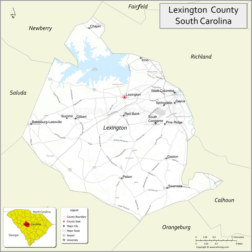
About Lexington County Map, South Carolina: The map showing the county boundary, county seat, major cities, highways, water bodies and neighbouring counties.
Related South Carolina Links
Map of Lexington County, South Carolina
Lexington County is a county located in the U.S. state of South Carolina. It's county seat is Lexington. As per 2020 census, the population of Lexington County is 300137 people and population density is square miles. According to the United States Census Bureau, the county has a total area of 758 sq mi (1,963 km2). Lexington County was established on 1804.
Lexington County Facts
| Continent | North America |
| Country | United States |
| State | South Carolina |
| County Seat | Lexington |
| Largest City/Town | Lexington |
| Established | 1785 |
| Total Area | 758 sq mi (1,963 sq km) |
| Land Area | 699 sq mi (1,810 sq km) |
| Water Area | 59 sq mi (153 sq km) |
| Population | 293,991 (Census 2020) |
| Population Density | 421 people per sq mi |
| Time Zone | Eastern (UTC-5 / UTC-4 DST) |
| Major Highways | I-20, I-26, I-77, US-1, US-21, US-378 |
| Major Rivers | Saluda River, Congaree River |
| Neighboring Counties | Richland, Newberry, Saluda, Aiken, Orangeburg, Calhoun |
| Famous For | Lake Murray, suburban growth near Columbia |
| Top Attractions | Lake Murray, Riverbanks Zoo (nearby), Dreher Island State Park |
| Official Website | Official Website |
About Lexington County, South Carolina
Lexington County is located in the central part of South Carolina, in the state of the United States, and was established in 1785. The county seat is Lexington, which is also the largest town. The county lies along the Saluda and Congaree rivers and is part of the Columbia metropolitan area, known for its rapid growth and proximity to Lake Murray.
Cities and Towns in Lexington County, South Carolina
| City/Town | Population (Census 2020) | Latitude & Longitude |
|---|---|---|
| Lexington (county seat) | 23,568 | 33.9815°N, 81.2362°W |
| West Columbia | 17,998 | 33.9935°N, 81.0737°W |
| Cayce | 13,994 | 33.9657°N, 81.0734°W |
| Irmo | 12,941 | 34.0857°N, 81.1832°W |
| Springdale | 2,636 | 33.9582°N, 81.0993°W |
| Pine Ridge | 2,168 | 33.9107°N, 81.1037°W |
| Swansea | 533 | 33.7399°N, 81.1045°W |
| Batesburg-Leesville | 5,018 | 33.9071°N, 81.5457°W |
| Red Bank (CDP) | 9,617 | 33.9329°N, 81.2209°W |
| Oak Grove (CDP) | 10,291 | 33.9493°N, 81.0962°W |
| Seven Oaks (CDP) | 15,068 | 34.0488°N, 81.1465°W |
| Pelion | 674 | 33.7635°N, 81.2418°W |
Golf Courses in Lexington County, South Carolina
| Golf Course | Location | Latitude & Longitude |
|---|---|---|
| Golden Hills Golf & Country Club | Lexington | 33.9908°N, 81.2465°W |
| Charwood Golf Club | West Columbia | 33.9119°N, 81.1230°W |
| Indian River Golf Club | West Columbia | 33.9451°N, 81.1502°W |
| Ponderosa Country Club | Leesville | 33.8895°N, 81.5124°W |
| LinRick Golf Course | Irmo | 34.1002°N, 81.1810°W |
| Mid Carolina Club | Batesburg-Leesville | 33.9002°N, 81.5401°W |
Roads and Highways in Lexington County, South Carolina
Major highways provide strong connectivity to Columbia and other nearby regions.
- Interstate 20 - east-west route connecting Columbia and Augusta
- Interstate 26 - links Columbia with Charleston
- Interstate 77 - north-south corridor through the region
- US Highway 1 - connects local towns and Columbia
- US Highway 378 - links Lexington with Sumter and Columbia
Neighboring Counties of Lexington County
- Newberry County (north)
- Richland County (east)
- Calhoun County (southeast)
- Orangeburg County (south)
- Aiken County (southwest)
- Saluda County (west)
Top Attractions in Lexington County, South Carolina
The county features lakes, parks, and recreational attractions.
- Lake Murray - large reservoir popular for boating and fishing
- Dreher Island State Park - scenic park with camping and lake access
- Virginia Hylton Park - community park with trails and events
- Saluda Shoals Park - riverside park with walking paths and playgrounds
- Cayce Riverwalk - scenic walking trail along the Congaree River
- Lexington County Museum - local history exhibits and heritage buildings
Distance from Lexington County to Nearby Cities
The following distances are measured by road (driving), with approximate straight-line (air) distances included where available.
- Lexington to Columbia (Richland County), South Carolina - 15 mi (24 km) by road, 12 mi (19 km) by air
- Lexington to Aiken (Aiken County), South Carolina - 45 mi (72 km) by road, 38 mi (61 km) by air
- Lexington to Newberry (Newberry County), South Carolina - 35 mi (56 km) by road, 30 mi (48 km) by air
- Lexington to Orangeburg (Orangeburg County), South Carolina - 40 mi (64 km) by road, 33 mi (53 km) by air
- Lexington to Sumter (Sumter County), South Carolina - 55 mi (89 km) by road, 45 mi (72 km) by air
- Lexington to Greenville (Greenville County), South Carolina - 95 mi (153 km) by road, 85 mi (137 km) by air
- Lexington to Charleston (Charleston County), South Carolina - 110 mi (177 km) by road, 95 mi (153 km) by air
- Lexington to Rock Hill (York County), South Carolina - 85 mi (137 km) by road, 75 mi (121 km) by air
- Lexington to Florence (Florence County), South Carolina - 80 mi (129 km) by road, 70 mi (113 km) by air
- Lexington to Augusta, Georgia - 65 mi (105 km) by road, 55 mi (89 km) by air
- Lexington to Charlotte, North Carolina - 95 mi (153 km) by road, 85 mi (137 km) by air
- Lexington to Savannah, Georgia - 140 mi (225 km) by road, 120 mi (193 km) by air
FAQs about Lexington County
Lexington County is located in the central Midlands region of South Carolina near Columbia.
The population of Lexington County is 293,991 according to the 2020 Census.
The county is known for Lake Murray, suburban growth, and its proximity to the state capital.
Major highways include I-20, I-26, I-77, US-1, US-378, and SC-6.
Yes, golf courses such as Golden Hills Golf & Country Club and Charwood Golf Club are located in the county.
- Abbeville County Map
- Aiken County Map
- Allendale County Map
- Anderson County Map
- Bamberg County Map
- Barnwell County Map
- Beaufort County Map
- Berkeley County Map
- Calhoun County Map
- Charleston County Map
- Cherokee County Map
- Chester County Map
- Chesterfield County Map
- Clarendon County Map
- Colleton County Map
- Darlington County Map
- Dillon County Map
- Dorchester County Map
- Edgefield County Map
- Fairfield County Map
- Florence County Map
- Georgetown County Map
- Greenville County Map
- Greenwood County Map
- Hampton County Map
- Horry County Map
- Jasper County Map
- Kershaw County Map
- Lancaster County Map
- Laurens County Map
- Lee County Map
- Lexington County Map
- McCormick County Map
- Marion County Map
- Marlboro County Map
- Newberry County Map
- Oconee County Map
- Orangeburg County Map
- Pickens County Map
- Richland County Map
- Saluda County Map
- Spartanburg County Map
- Sumter County Map
- Union County Map
- Williamsburg County Map
- York County Map
- Alabama Counties
- Alaska boroughs
- Arizona Counties
- Arkansas Counties
- California County Map
- Colorado Counties
- Connecticut Counties
- Delaware Counties
- Florida County Map
- Georgia County Map
- Hawaii Counties
- Idaho Counties
- Illinois Counties
- Indiana Counties
- Iowa Counties
- Kansas Counties
- Kentucky Counties
- Louisiana Counties
- Maine Counties
- Maryland Counties
- Massachusetts Counties
- Michigan County Map
- Minnesota Counties
- Mississippi Counties
- Missouri Counties
- Montana Counties
- Nebraska Counties
- Nevada Counties
- New York Counties
- New Hampshire Counties
- New Jersey Counties
- New Mexico Counties
- North Carolina Counties
- North Dakota Counties
- Ohio County Map
- Oklahoma Counties
- Oregon Counties
- Pennsylvania Counties
- Rhode Island Counties
- South Carolina Counties
- South Dakota Counties
- Map of Tennessee
- Texas County Map
- Utah Counties
- Vermont Counties
- Virginia Counties
- Washington Counties
- West Virginia Counties
- Wisconsin Counties
- Wyoming Counties