Written and Fact-checked by Whereig Editors | Updated On: May 05, 2026 | 14:50 ET
Map of Charleston County - Charleston County is a county located in the U.S. state of South Carolina. Charleston County Map showing cities, highways, important places and water bodies. Get Where is Charleston County located in the map, major cities in Charleston county, population, areas, and places of interest.
Map of Charleston County, South Carolina
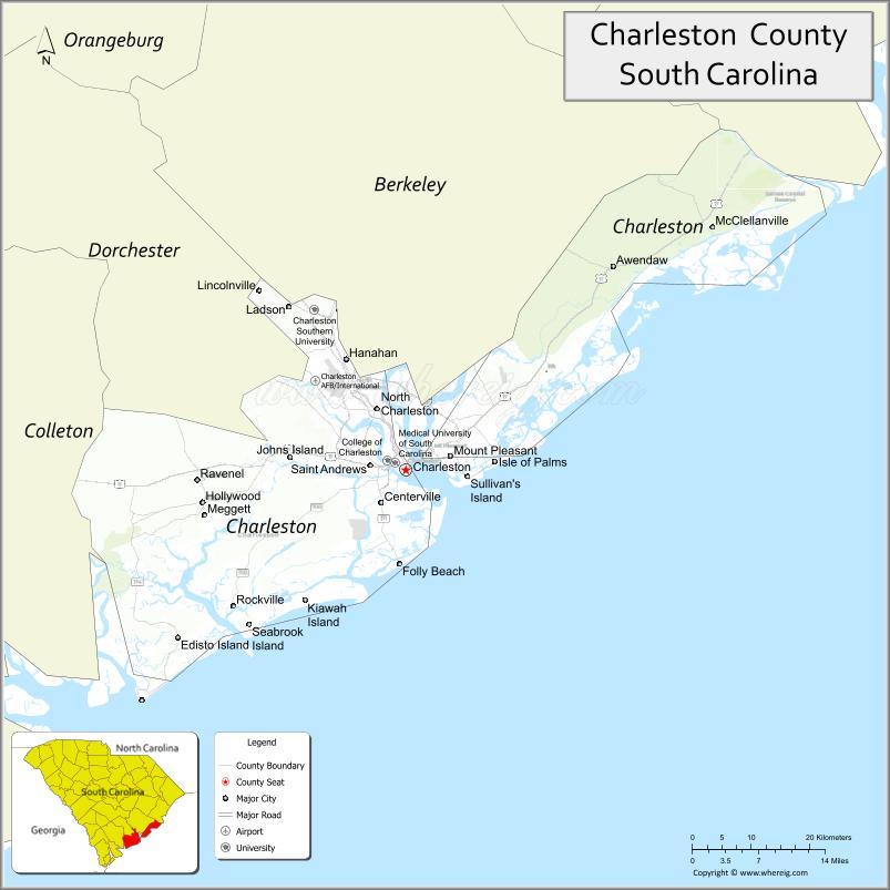
About Charleston County Map, South Carolina: The map showing the county boundary, county seat, major cities, highways, water bodies and neighbouring counties.
Related South Carolina Links
Map of Charleston County, South Carolina
Charleston County is a county located in the U.S. state of South Carolina. It's county seat is Charleston. As per 2020 census, the population of Charleston County is 413024 people and population density is square miles. According to the United States Census Bureau, the county has a total area of 1,358 sq mi (3,517 km2). Charleston County was established on 1769.
Charleston County Facts
| Continent | North America |
| Country | United States |
| State | South Carolina |
| County Seat | Charleston |
| Largest City/Town | Charleston |
| Established | 1769 |
| Total Area | 1,357.03 sq mi (3,514.69 sq km) |
| Land Area | 916.40 sq mi (2,373.43 sq km) |
| Water Area | 440.63 sq mi (1,141.26 sq km) |
| Population | 408,235 (Census 2020) |
| Population Density | 445.6 people per sq mi |
| Time Zone | Eastern (EST) |
| Major Highways | I-26, I-526, US-17, US-52, US-78, SC-61 |
| Major Rivers | Ashley River, Cooper River, Stono River |
| Neighboring Counties | Berkeley, Dorchester, Colleton |
| Famous For | Historic Charleston, beaches, tourism, port |
| Top Attractions | Historic Charleston, Folly Beach, Isle of Palms, Fort Sumter, Waterfront Park |
| Official Website | Official Website |
About Charleston County, South Carolina
Charleston County is located in the southeastern coastal part of South Carolina in the United States and was established in 1769. The county seat is Charleston, which is also the largest city. The county lies in the Lowcountry region and is known for its historic significance, coastal scenery, barrier islands, and major port activity.
Cities and Towns in Charleston County, South Carolina
| City/Town | Population (Census 2020) | Latitude & Longitude |
|---|---|---|
| Charleston (county seat) | 150,227 | 32.7765N, 79.9311W |
| North Charleston (partly) | 114,852 | 32.8546N, 79.9748W |
| Mount Pleasant | 90,801 | 32.7941N, 79.8626W |
| Summerville (partly) | 50,915 | 33.0185N, 80.1756W |
| Folly Beach | 2,617 | 32.6552N, 79.9409W |
| Isle of Palms | 4,133 | 32.7866N, 79.7948W |
| Sullivan�s Island | 1,891 | 32.7632N, 79.8360W |
| Ravenel | 2,438 | 32.7635N, 80.2401W |
| Lincolnville (partly) | 1,208 | 32.9902N, 80.1593W |
| Hollywood | 5,616 | 32.7374N, 80.2434W |
| Meggett | 1,226 | 32.7168N, 80.2331W |
| McClellanville | 618 | 33.0877N, 79.4617W |
| Awendaw | 1,293 | 33.0374N, 79.6131W |
| James Island (CDP) | 11,900+ | 32.7230N, 79.9515W |
| Johns Island (CDP) | 21,000+ | 32.7240N, 80.0856W |
| West Ashley (CDP) | 30,000+ | 32.8407N, 80.0340W |
Golf Courses in Charleston County, South Carolina
| Golf Course | Location | Latitude & Longitude |
|---|---|---|
| Kiawah Island Golf Resort (Ocean Course) | Kiawah Island | 32.6080N, 80.0833W |
| Wild Dunes Resort Golf Course | Isle of Palms | 32.8016N, 79.7445W |
| Patriots Point Links | Mount Pleasant | 32.7818N, 79.9016W |
| Shadowmoss Golf & Country Club | Charleston | 32.8410N, 80.0823W |
| Charleston Municipal Golf Course | Charleston | 32.7578N, 79.9856W |
| Stono Ferry Golf Course | Hollywood | 32.7422N, 80.2117W |
| RiverTowne Country Club | Mount Pleasant | 32.8865N, 79.7904W |
Roads and Highways in Charleston County, South Carolina
The county has a well-developed highway network supporting tourism and regional travel.
- I-26 - major interstate connecting Charleston to Columbia
- I-526 - beltway around Charleston metro area
- US-17 - coastal highway running through Charleston and Mount Pleasant
- US-52 - connects North Charleston to inland areas
- US-78 - links Charleston to North Charleston and beyond
- SC-61 - scenic highway through historic plantations
Neighboring Counties of Charleston County
- Berkeley County (north)
- Dorchester County (west)
- Colleton County (southwest)
Top Attractions in Charleston County, South Carolina
The county is one of the most visited destinations in the southeastern United States.
- Historic Charleston - cobblestone streets, architecture, and culture
- Folly Beach - laid-back beach with surfing and fishing
- Isle of Palms - resort-style beaches and vacation homes
- Fort Sumter National Monument - Civil War historic site
- Waterfront Park - scenic harbor views and fountains
- Magnolia Plantation and Gardens - historic gardens and nature trails
- Kiawah Island - luxury resorts and golf courses
- Charleston City Market - local crafts and historic marketplace
Distance from Charleston County to Nearby Cities
- Charleston to Columbia - 115 mi (185 km)
- Charleston to Savannah - 110 mi (177 km)
- Charleston to Myrtle Beach - 95 mi (153 km)
- Charleston to Augusta - 140 mi (225 km)
- Charleston to Atlanta - 300 mi (483 km)
FAQs about Charleston County
Charleston County is located in the southeastern coastal region of South Carolina along the Atlantic Ocean.
The population of Charleston County is 408,235 according to the 2020 Census.
The county is known for its historic city of Charleston, beaches, tourism, and major port.
Major highways include I-26, I-526, US-17, US-52, US-78, and SC-61.
Yes, Charleston County has many golf courses including Kiawah Island Golf Resort and Patriots Point Links.
- Abbeville County Map
- Aiken County Map
- Allendale County Map
- Anderson County Map
- Bamberg County Map
- Barnwell County Map
- Beaufort County Map
- Berkeley County Map
- Calhoun County Map
- Charleston County Map
- Cherokee County Map
- Chester County Map
- Chesterfield County Map
- Clarendon County Map
- Colleton County Map
- Darlington County Map
- Dillon County Map
- Dorchester County Map
- Edgefield County Map
- Fairfield County Map
- Florence County Map
- Georgetown County Map
- Greenville County Map
- Greenwood County Map
- Hampton County Map
- Horry County Map
- Jasper County Map
- Kershaw County Map
- Lancaster County Map
- Laurens County Map
- Lee County Map
- Lexington County Map
- McCormick County Map
- Marion County Map
- Marlboro County Map
- Newberry County Map
- Oconee County Map
- Orangeburg County Map
- Pickens County Map
- Richland County Map
- Saluda County Map
- Spartanburg County Map
- Sumter County Map
- Union County Map
- Williamsburg County Map
- York County Map
- Alabama Counties
- Alaska boroughs
- Arizona Counties
- Arkansas Counties
- California County Map
- Colorado Counties
- Connecticut Counties
- Delaware Counties
- Florida County Map
- Georgia County Map
- Hawaii Counties
- Idaho Counties
- Illinois Counties
- Indiana Counties
- Iowa Counties
- Kansas Counties
- Kentucky Counties
- Louisiana Counties
- Maine Counties
- Maryland Counties
- Massachusetts Counties
- Michigan County Map
- Minnesota Counties
- Mississippi Counties
- Missouri Counties
- Montana Counties
- Nebraska Counties
- Nevada Counties
- New York Counties
- New Hampshire Counties
- New Jersey Counties
- New Mexico Counties
- North Carolina Counties
- North Dakota Counties
- Ohio County Map
- Oklahoma Counties
- Oregon Counties
- Pennsylvania Counties
- Rhode Island Counties
- South Carolina Counties
- South Dakota Counties
- Map of Tennessee
- Texas County Map
- Utah Counties
- Vermont Counties
- Virginia Counties
- Washington Counties
- West Virginia Counties
- Wisconsin Counties
- Wyoming Counties