Written and Fact-checked by Whereig Editors | Updated On: May 05, 2026 | 14:50 ET
Map of McCormick County - McCormick County is a county located in the U.S. state of South Carolina. McCormick County Map showing cities, highways, important places and water bodies. Get Where is McCormick County located in the map, major cities in McCormick county, population, areas, and places of interest.
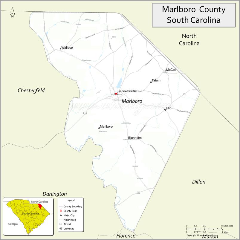
Map of Marlboro County, South Carolina
About McCormick County Map, South Carolina: The map showing the county boundary, county seat, major cities, highways, water bodies and neighbouring counties.
Related South Carolina Links
Map of Marlboro County, South Carolina
Marlboro County is a county located in the U.S. state of South Carolina. It's county seat is Bennettsville. As per 2020 census, the population of Marlboro County is 26382 people and population density is square miles. According to the United States Census Bureau, the county has a total area of 485 sq mi (1,256 km2). Marlboro County was established on 1785.
Marlboro County Facts
| Continent | North America |
| Country | United States |
| State | South Carolina |
| County Seat | Bennettsville |
| Largest City/Town | Bennettsville |
| Established | 1785 |
| Total Area | 485.87 sq mi (1,258.39 sq km) |
| Land Area | 480.12 sq mi (1,243.51 sq km) |
| Water Area | 5.75 sq mi (14.88 sq km) |
| Population | 26,667 (Census 2020) |
| Population Density | 55.5 people per sq mi |
| Time Zone | Eastern (EST) |
| Major Highways | US-15, US-401, SC-9, SC-38 |
| Major Rivers | Great Pee Dee River, Lumber River |
| Neighboring Counties | Dillon, Marion, Darlington, Chesterfield, Richmond (NC), Scotland (NC) |
| Famous For | Historic Bennettsville, agriculture, tobacco heritage |
| Top Attractions | Marlboro County Historical Museum, Lake Paul Wallace, Bennettsville Historic District |
| Official Website | Official Website |
About Marlboro County, South Carolina
Marlboro County is located in the northeastern part of South Carolina in the United States and was established in 1785. The county seat is Bennettsville, which is also the largest city. The county lies in the Pee Dee region near the North Carolina border and is known for its agricultural history, particularly tobacco farming, and its historic downtown areas.
Cities and Towns in Marlboro County, South Carolina
| City/Town | Population (Census 2020) | Latitude & Longitude |
|---|---|---|
| Bennettsville (county seat) | 7,425 | 34.6174N, 79.6848W |
| Clio | 800 | 34.5752N, 79.5456W |
| McColl | 2,000+ | 34.6685N, 79.5448W |
| Tatum (partly) | 100+ | 34.6900N, 79.5600W |
| Wallace (CDP) | ~N/A | 34.7100N, 79.5600W |
| Brownsville (CDP) | ~N/A | 34.6000N, 79.6500W |
Golf Courses in Marlboro County, South Carolina
| Golf Course | Location | Latitude & Longitude |
|---|---|---|
| Marlboro County Golf & Recreation Complex | Bennettsville | 34.6200N, 79.6900W |
| Fox Hollow Golf Club (nearby) | Mullins area | 34.2070N, 79.2600W |
Roads and Highways in Marlboro County, South Carolina
The county is served by highways connecting it to neighboring regions and states.
- US-15 - north-south route connecting to North Carolina and Sumter
- US-401 - links Bennettsville to nearby counties and North Carolina
- SC-9 - connects to Dillon and Chesterfield counties
- SC-38 - runs through the county providing regional access
Neighboring Counties of Marlboro County
- Richmond County, North Carolina (north)
- Scotland County, North Carolina (north)
- Chesterfield County (west)
- Darlington County (southwest)
- Marion County (south)
- Dillon County (east)
Top Attractions in Marlboro County, South Carolina
The county features historic sites and outdoor recreation.
- Bennettsville Historic District - preserved downtown and architecture
- Marlboro County Historical Museum - exhibits on local history
- Lake Paul Wallace - fishing, boating, and recreation
- Great Pee Dee River - scenic views and outdoor activities
- Lumber River - kayaking and fishing
- Local farms - agricultural heritage and seasonal produce
Distance from Marlboro County to Nearby Cities
- Bennettsville to Florence - 35 mi (56 km)
- Bennettsville to Myrtle Beach - 80 mi (129 km)
- Bennettsville to Columbia - 90 mi (145 km)
- Bennettsville to Charlotte - 90 mi (145 km)
- Bennettsville to Raleigh - 120 mi (193 km)
FAQs about Marlboro County
Marlboro County is located in the northeastern Pee Dee region of South Carolina near the North Carolina border.
The population of Marlboro County is 26,667 according to the 2020 Census.
The county is known for its agricultural heritage, especially tobacco farming, and historic Bennettsville.
Major highways include US-15, US-401, SC-9, and SC-38.
Yes, Marlboro County Golf & Recreation Complex is located in the county.
- Abbeville County Map
- Aiken County Map
- Allendale County Map
- Anderson County Map
- Bamberg County Map
- Barnwell County Map
- Beaufort County Map
- Berkeley County Map
- Calhoun County Map
- Charleston County Map
- Cherokee County Map
- Chester County Map
- Chesterfield County Map
- Clarendon County Map
- Colleton County Map
- Darlington County Map
- Dillon County Map
- Dorchester County Map
- Edgefield County Map
- Fairfield County Map
- Florence County Map
- Georgetown County Map
- Greenville County Map
- Greenwood County Map
- Hampton County Map
- Horry County Map
- Jasper County Map
- Kershaw County Map
- Lancaster County Map
- Laurens County Map
- Lee County Map
- Lexington County Map
- McCormick County Map
- Marion County Map
- Marlboro County Map
- Newberry County Map
- Oconee County Map
- Orangeburg County Map
- Pickens County Map
- Richland County Map
- Saluda County Map
- Spartanburg County Map
- Sumter County Map
- Union County Map
- Williamsburg County Map
- York County Map
- Alabama Counties
- Alaska boroughs
- Arizona Counties
- Arkansas Counties
- California County Map
- Colorado Counties
- Connecticut Counties
- Delaware Counties
- Florida County Map
- Georgia County Map
- Hawaii Counties
- Idaho Counties
- Illinois Counties
- Indiana Counties
- Iowa Counties
- Kansas Counties
- Kentucky Counties
- Louisiana Counties
- Maine Counties
- Maryland Counties
- Massachusetts Counties
- Michigan County Map
- Minnesota Counties
- Mississippi Counties
- Missouri Counties
- Montana Counties
- Nebraska Counties
- Nevada Counties
- New York Counties
- New Hampshire Counties
- New Jersey Counties
- New Mexico Counties
- North Carolina Counties
- North Dakota Counties
- Ohio County Map
- Oklahoma Counties
- Oregon Counties
- Pennsylvania Counties
- Rhode Island Counties
- South Carolina Counties
- South Dakota Counties
- Map of Tennessee
- Texas County Map
- Utah Counties
- Vermont Counties
- Virginia Counties
- Washington Counties
- West Virginia Counties
- Wisconsin Counties
- Wyoming Counties