Written and Fact-checked by Whereig Editors | Updated On: May 05, 2026 | 14:50 ET
Map of Dorchester County - Dorchester County is a county located in the U.S. state of South Carolina. Dorchester County Map showing cities, highways, important places and water bodies. Get Where is Dorchester County located in the map, major cities in Dorchester county, population, areas, and places of interest.
Map of Dorchester County, South Carolina
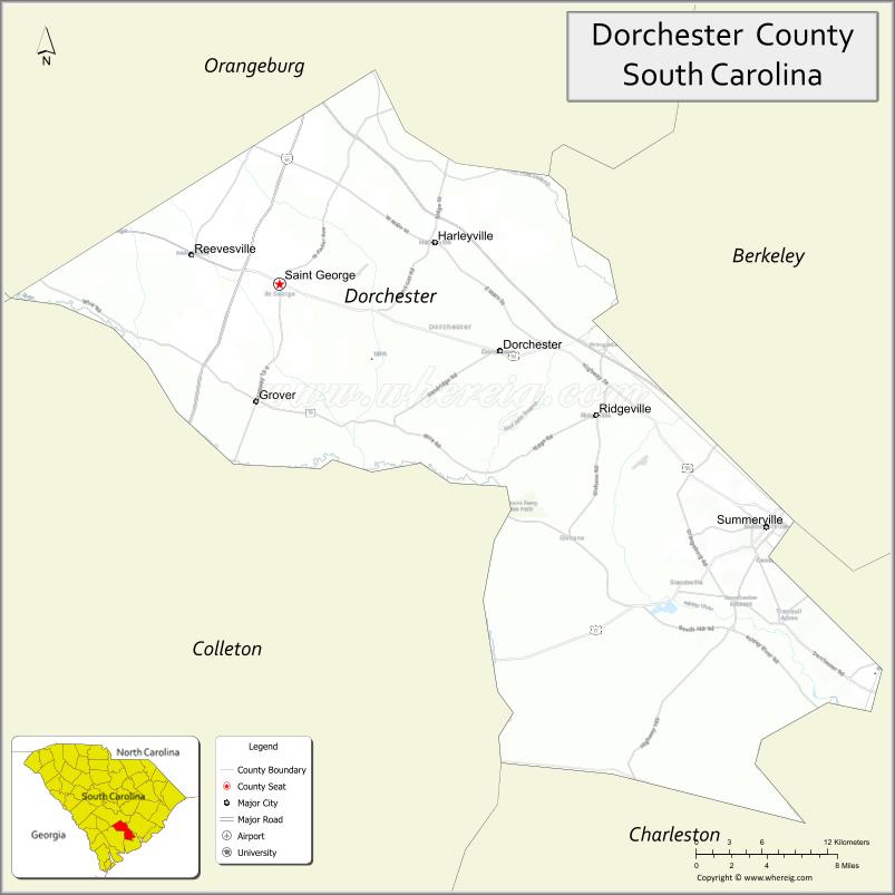
About Dorchester County Map, South Carolina: The map showing the county boundary, county seat, major cities, highways, water bodies and neighbouring counties.
Related South Carolina Links
Map of Dorchester County, South Carolina
Dorchester County is a county located in the U.S. state of South Carolina. It's county seat is St. George. As per 2020 census, the population of Dorchester County is 163327 people and population density is square miles. According to the United States Census Bureau, the county has a total area of 577 sq mi (1,494 km2). Dorchester County was established on 1868.
Dorchester County Facts
| Continent | North America |
| Country | United States |
| State | South Carolina |
| County Seat | St. George |
| Largest City/Town | Summerville |
| Established | 1897 |
| Total Area | 575.25 sq mi (1,489.89 sq km) |
| Land Area | 568.28 sq mi (1,472.84 sq km) |
| Water Area | 6.97 sq mi (18.05 sq km) |
| Population | 161,540 (Census 2020) |
| Population Density | 284.3 people per sq mi |
| Time Zone | Eastern (EST) |
| Major Highways | I-26, US-17A, US-78, SC-61, SC-165 |
| Major Rivers | Edisto River, Ashley River |
| Neighboring Counties | Berkeley, Charleston, Colleton, Orangeburg |
| Famous For | Summerville, Azalea Festival, suburban growth |
| Top Attractions | Azalea Park, Colonial Dorchester State Historic Site, Ashley River, Summerville Historic District |
| Official Website | Official Website |
About Dorchester County, South Carolina
Dorchester County is located in the southeastern part of South Carolina in the United States and was established in 1897. The county seat is St. George, while the largest town is Summerville. The county lies in the Lowcountry region and features a mix of suburban communities, historic sites, and river systems, with strong growth due to its proximity to Charleston.
Cities and Towns in Dorchester County, South Carolina
| City/Town | Population (Census 2020) | Latitude & Longitude |
|---|---|---|
| Summerville (partly) | 50,915 | 33.0185N, 80.1756W |
| St. George (county seat) | 2,092 | 33.1860N, 80.5751W |
| North Charleston (partly) | 114,852 | 32.8546N, 79.9748W |
| Ridgeville (partly) | 2,109 | 33.0957N, 80.3143W |
| Harleyville | 677 | 33.2340N, 80.4509W |
| Reevesville | 179 | 33.1971N, 80.6767W |
| Lincolnville | 1,208 | 32.9902N, 80.1593W |
| Woodland Heights (CDP) | 1,000+ | 33.0300N, 80.1600W |
| Ashley Forest (CDP) | ~N/A | 32.9000N, 80.1000W |
Golf Courses in Dorchester County, South Carolina
| Golf Course | Location | Latitude & Longitude |
|---|---|---|
| Wescott Golf Club | Summerville | 32.9415N, 80.1205W |
| Legend Oaks Golf Club | Summerville | 32.8763N, 80.1912W |
| Pine Forest Country Club | Summerville | 33.0052N, 80.1834W |
Roads and Highways in Dorchester County, South Carolina
The county is well connected by highways supporting commuters and regional travel.
- I-26 - major interstate connecting Charleston and Columbia
- US-17A - connects Summerville to Charleston and Moncks Corner
- US-78 - runs through the county linking nearby towns
- SC-61 - scenic route through historic areas
- SC-165 - connects rural communities within the county
Neighboring Counties of Dorchester County
- Berkeley County (north)
- Charleston County (east)
- Colleton County (southwest)
- Orangeburg County (west)
Top Attractions in Dorchester County, South Carolina
The county offers historic sites and outdoor attractions.
- Azalea Park - popular park known for seasonal blooms
- Colonial Dorchester State Historic Site - archaeological and historic area
- Summerville Historic District - charming downtown with shops and restaurants
- Ashley River - scenic waterway for kayaking and fishing
- Givhans Ferry State Park - hiking, camping, and river access
- Edisto River - one of the longest free-flowing blackwater rivers
Distance from Dorchester County to Nearby Cities
- Summerville to Charleston - 25 mi (40 km)
- Summerville to Columbia - 100 mi (161 km)
- Summerville to Savannah - 90 mi (145 km)
- Summerville to Myrtle Beach - 95 mi (153 km)
- Summerville to Augusta - 140 mi (225 km)
FAQs about Dorchester County
Dorchester County is located in the southeastern Lowcountry region of South Carolina near Charleston.
The population of Dorchester County is 161,540 according to the 2020 Census.
The county is known for Summerville, the Azalea Festival, and its growing suburban communities.
Major highways include I-26, US-17A, US-78, SC-61, and SC-165.
Yes, golf courses such as Wescott Golf Club, Legend Oaks Golf Club, and Pine Forest Country Club are located in the county.
- Abbeville County Map
- Aiken County Map
- Allendale County Map
- Anderson County Map
- Bamberg County Map
- Barnwell County Map
- Beaufort County Map
- Berkeley County Map
- Calhoun County Map
- Charleston County Map
- Cherokee County Map
- Chester County Map
- Chesterfield County Map
- Clarendon County Map
- Colleton County Map
- Darlington County Map
- Dillon County Map
- Dorchester County Map
- Edgefield County Map
- Fairfield County Map
- Florence County Map
- Georgetown County Map
- Greenville County Map
- Greenwood County Map
- Hampton County Map
- Horry County Map
- Jasper County Map
- Kershaw County Map
- Lancaster County Map
- Laurens County Map
- Lee County Map
- Lexington County Map
- McCormick County Map
- Marion County Map
- Marlboro County Map
- Newberry County Map
- Oconee County Map
- Orangeburg County Map
- Pickens County Map
- Richland County Map
- Saluda County Map
- Spartanburg County Map
- Sumter County Map
- Union County Map
- Williamsburg County Map
- York County Map
- Alabama Counties
- Alaska boroughs
- Arizona Counties
- Arkansas Counties
- California County Map
- Colorado Counties
- Connecticut Counties
- Delaware Counties
- Florida County Map
- Georgia County Map
- Hawaii Counties
- Idaho Counties
- Illinois Counties
- Indiana Counties
- Iowa Counties
- Kansas Counties
- Kentucky Counties
- Louisiana Counties
- Maine Counties
- Maryland Counties
- Massachusetts Counties
- Michigan County Map
- Minnesota Counties
- Mississippi Counties
- Missouri Counties
- Montana Counties
- Nebraska Counties
- Nevada Counties
- New York Counties
- New Hampshire Counties
- New Jersey Counties
- New Mexico Counties
- North Carolina Counties
- North Dakota Counties
- Ohio County Map
- Oklahoma Counties
- Oregon Counties
- Pennsylvania Counties
- Rhode Island Counties
- South Carolina Counties
- South Dakota Counties
- Map of Tennessee
- Texas County Map
- Utah Counties
- Vermont Counties
- Virginia Counties
- Washington Counties
- West Virginia Counties
- Wisconsin Counties
- Wyoming Counties