Written and Fact-checked by Whereig Editors | Updated On: May 05, 2026 | 14:50 ET
Map of Horry County - Horry County is a county located in the U.S. state of South Carolina. Horry County Map showing cities, highways, important places and water bodies. Get Where is Horry County located in the map, major cities in Horry county, population, areas, and places of interest.
Map of Horry County, South Carolina
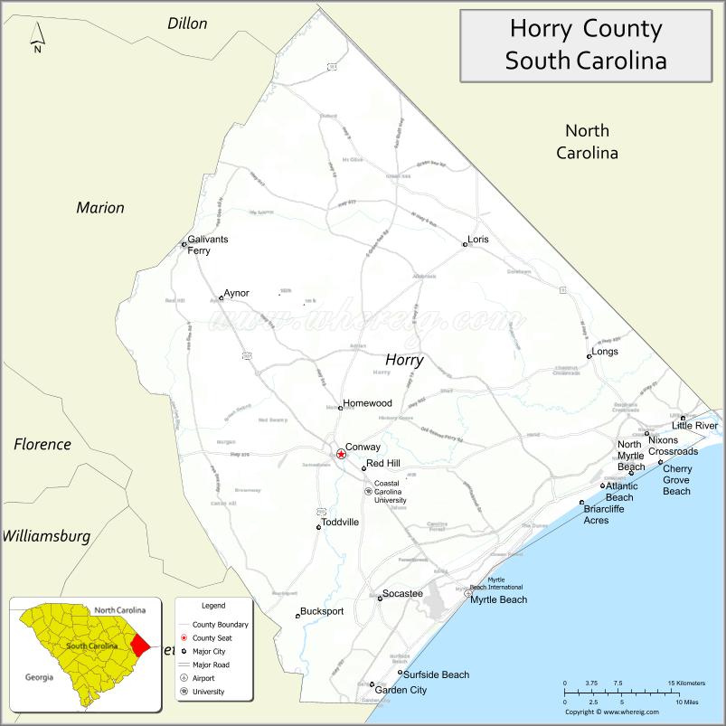
About Horry County Map, South Carolina: The map showing the county boundary, county seat, major cities, highways, water bodies and neighbouring counties.
Related South Carolina Links
Map of Horry County, South Carolina
Horry County is a county located in the U.S. state of South Carolina. It's county seat is Conway. As per 2020 census, the population of Horry County is 365579 people and population density is square miles. According to the United States Census Bureau, the county has a total area of 1,255 sq mi (3,250 km2). Horry County was established on 1801.
Horry County Facts
| Continent | North America |
| Country | United States |
| State | South Carolina |
| County Seat | Conway |
| Largest City/Town | Myrtle Beach |
| Established | 1801 |
| Total Area | 1,255.48 sq mi (3,252.66 sq km) |
| Land Area | 1,133.36 sq mi (2,934.36 sq km) |
| Water Area | 122.12 sq mi (316.30 sq km) |
| Population | 351,029 (Census 2020) |
| Population Density | 309.7 people per sq mi |
| Time Zone | Eastern (EST) |
| Major Highways | I-95 (nearby), US-17, US-501, SC-31, SC-22 |
| Major Rivers | Waccamaw River, Little Pee Dee River, Atlantic Intracoastal Waterway |
| Neighboring Counties | Georgetown, Marion, Columbus (NC), Brunswick (NC) |
| Famous For | Myrtle Beach, tourism, Grand Strand coastline |
| Top Attractions | Myrtle Beach Boardwalk, Broadway at the Beach, Brookgreen Gardens, Huntington Beach State Park |
| Official Website | Official Website |
About Horry County, South Carolina
Horry County is located in the northeastern coastal part of South Carolina in the United States and was established in 1801. The county seat is Conway, while the largest city is Myrtle Beach. The county lies along the Atlantic Ocean in the Grand Strand region and is known for its beaches, tourism industry, golf courses, and rapidly growing population.
Cities and Towns in Horry County, South Carolina
| City/Town | Population (Census 2020) | Latitude & Longitude |
|---|---|---|
| Myrtle Beach | 35,682 | 33.6891N, 78.8867W |
| Conway (county seat) | 24,849 | 33.8360N, 79.0478W |
| North Myrtle Beach | 18,790 | 33.8160N, 78.6800W |
| Surfside Beach | 4,425 | 33.6057N, 78.9731W |
| Garden City | 9,200+ | 33.5924N, 79.0025W |
| Socastee (CDP) | 22,000+ | 33.6830N, 79.0050W |
| Carolina Forest (CDP) | 25,000+ | 33.7600N, 78.9000W |
| Loris | 2,300 | 34.0563N, 78.8906W |
| Aynor | 870 | 33.9932N, 79.2017W |
Golf Courses in Horry County, South Carolina
| Golf Course | Location | Latitude & Longitude |
|---|---|---|
| Dunes Golf & Beach Club | Myrtle Beach | 33.7435N, 78.8254W |
| TPC Myrtle Beach | Murrells Inlet area | 33.5758N, 79.0882W |
| Caledonia Golf & Fish Club | Pawleys Island area | 33.4302N, 79.1420W |
| Barefoot Resort & Golf | North Myrtle Beach | 33.8012N, 78.7485W |
| Grande Dunes Resort Club | Myrtle Beach | 33.7392N, 78.8298W |
Roads and Highways in Horry County, South Carolina
The county is a major travel destination with well-developed highway infrastructure.
- US-17 - coastal highway running along the Grand Strand
- US-501 - major route connecting Myrtle Beach to inland South Carolina
- SC-31 - Carolina Bays Parkway bypass around Myrtle Beach
- SC-22 - Conway Bypass connecting US-501 to North Myrtle Beach
- I-95 - located west of the county, providing regional access
Neighboring Counties of Horry County
- Columbus County, North Carolina (north)
- Brunswick County, North Carolina (northeast)
- Georgetown County (south)
- Marion County (west)
Top Attractions in Horry County, South Carolina
The county is one of the top tourist destinations on the East Coast.
- Myrtle Beach Boardwalk - oceanfront promenade with shops and attractions
- Broadway at the Beach - entertainment, dining, and shopping complex
- Brookgreen Gardens - sculpture garden and wildlife preserve
- Huntington Beach State Park - beaches, nature, and Atalaya Castle
- SkyWheel Myrtle Beach - large observation wheel with ocean views
- Waccamaw River - kayaking, fishing, and scenic tours
Distance from Horry County to Nearby Cities
- Myrtle Beach to Wilmington - 75 mi (121 km)
- Myrtle Beach to Florence - 70 mi (113 km)
- Myrtle Beach to Charleston - 95 mi (153 km)
- Myrtle Beach to Columbia - 150 mi (241 km)
- Myrtle Beach to Raleigh - 180 mi (290 km)
FAQs about Horry County
Horry County is located in the northeastern coastal region of South Carolina along the Atlantic Ocean.
The population of Horry County is 351,029 according to the 2020 Census.
The county is known for Myrtle Beach, tourism, and the Grand Strand coastline.
Major highways include US-17, US-501, SC-31, SC-22, and nearby I-95.
Yes, Horry County is famous for golf, with many courses including Dunes Golf & Beach Club and TPC Myrtle Beach.
- Abbeville County Map
- Aiken County Map
- Allendale County Map
- Anderson County Map
- Bamberg County Map
- Barnwell County Map
- Beaufort County Map
- Berkeley County Map
- Calhoun County Map
- Charleston County Map
- Cherokee County Map
- Chester County Map
- Chesterfield County Map
- Clarendon County Map
- Colleton County Map
- Darlington County Map
- Dillon County Map
- Dorchester County Map
- Edgefield County Map
- Fairfield County Map
- Florence County Map
- Georgetown County Map
- Greenville County Map
- Greenwood County Map
- Hampton County Map
- Horry County Map
- Jasper County Map
- Kershaw County Map
- Lancaster County Map
- Laurens County Map
- Lee County Map
- Lexington County Map
- McCormick County Map
- Marion County Map
- Marlboro County Map
- Newberry County Map
- Oconee County Map
- Orangeburg County Map
- Pickens County Map
- Richland County Map
- Saluda County Map
- Spartanburg County Map
- Sumter County Map
- Union County Map
- Williamsburg County Map
- York County Map
- Alabama Counties
- Alaska boroughs
- Arizona Counties
- Arkansas Counties
- California County Map
- Colorado Counties
- Connecticut Counties
- Delaware Counties
- Florida County Map
- Georgia County Map
- Hawaii Counties
- Idaho Counties
- Illinois Counties
- Indiana Counties
- Iowa Counties
- Kansas Counties
- Kentucky Counties
- Louisiana Counties
- Maine Counties
- Maryland Counties
- Massachusetts Counties
- Michigan County Map
- Minnesota Counties
- Mississippi Counties
- Missouri Counties
- Montana Counties
- Nebraska Counties
- Nevada Counties
- New York Counties
- New Hampshire Counties
- New Jersey Counties
- New Mexico Counties
- North Carolina Counties
- North Dakota Counties
- Ohio County Map
- Oklahoma Counties
- Oregon Counties
- Pennsylvania Counties
- Rhode Island Counties
- South Carolina Counties
- South Dakota Counties
- Map of Tennessee
- Texas County Map
- Utah Counties
- Vermont Counties
- Virginia Counties
- Washington Counties
- West Virginia Counties
- Wisconsin Counties
- Wyoming Counties