
Where is Moncks Corner Located? - Moncks Corner is a city located in the Berkeley County of South Carolina, United States. Moncks Corner lies between 36.4336481 Degrees North latitudes and 99.3903862 Degrees West longitudes.
Location Map of Moncks Corner, South Carolina
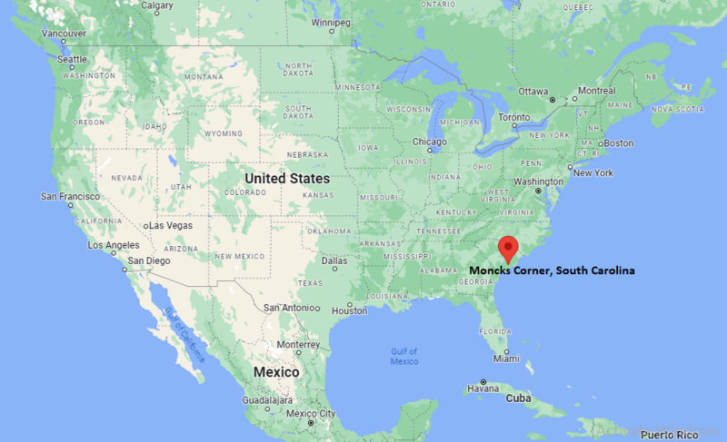
Moncks Corner Map, South Carolina, USA
Where is Moncks Corner?: The Google Map showing the location of Moncks Corner in the U.S. state of South Carolina.
Where is Moncks Corner Located?
Moncks Corner is a city located in the Berkeley County of South Carolina, United States. Moncks Corner lies between 36.4336481 Degrees North latitudes and 99.3903862 Degrees West longitudes. According to 2020 U.S.census, the population of Moncks Corner city is 13297 people and the city has a total area of 8.61 sq mi. The city has numerous parks and recreational facilities.
Most Viewed US Maps
| USA Sttae Map | USA Region Map | USA Road Map |
| USA County Map | Where is USA in World Map? | US ZIP Code Map |
| USA Time Zones Map | US State and Capitals Map | USA Physical Map |
Find 4,400+ U.S. Cities by State - Explore Their Locations and Get Detailed Information
Moncks Corner, South Carolina Quick Facts
| Attribute | Information |
|---|---|
| City | Moncks Corner |
| County | Berkeley County |
| State | South Carolina |
| State Capital | Columbia |
| US Region | South Atlantic (Southeastern United States) |
| Latitude | 33.1960° N |
| Longitude | 80.0134° W |
| Elevation | 52 ft (16 m) |
| Land Area | 8.34 sq mi |
| Water Area | 0.11 sq mi |
| Total Area | 8.45 sq mi |
| Population (2020 Census) | 13,297 |
| Population Density | Approximately 1,594 per sq mi |
| ZIP Codes | 29461 |
| Area Code | 843, 854 |
| Time Zone Standard | Eastern Standard Time (EST, UTC−5) |
| Time Zone Daylight | Eastern Daylight Time (EDT, UTC−4) |
| Currency | United States Dollar (USD) |
| FIPS Code | 45-46375 |
| Congressional District | South Carolina's 6th Congressional District |
Transportation and Connectivity in Moncks Corner
| Category | Information |
|---|---|
| Airport Name | Charleston International Airport |
| IATA Code | CHS |
| Port | Port of Charleston (regional access) |
| Major Highways | U.S. Highway 52, U.S. Highway 17A, South Carolina Highway 6 |
| Train/Amtrak Service | Nearest Amtrak station is North Charleston |
| Local Bus/Transit Service | Berkeley-Charleston-Dorchester Council of Governments (BCDCOG) regional transit services |
- U.S. Highway 52 – Primary highway connecting Moncks Corner with Charleston, Goose Creek, and Florence.
- U.S. Highway 17A – Important regional route linking the town with Summerville, Walterboro, and nearby communities.
- South Carolina Highway 6 – East–west corridor connecting Moncks Corner with Santee, Cross, and Interstate 26.
- Altman Street – Main downtown roadway serving local businesses, government offices, and community facilities.
Top Places to Visit in Moncks Corner, South Carolina
| Landmark Name | Type |
|---|---|
| Old Santee Canal Park | Historic Park |
| Cypress Gardens | Botanical Garden |
| Lake Moultrie | Lake |
| Berkeley County Museum | Museum |
| Mepkin Abbey | Historic Religious Site |
| Tailrace Canal | Fishing Area |
| Lake Moultrie Recreation Area | Recreation Area |
| Biggin Church Ruins | Historic Site |
| Francis Marion National Forest | National Forest |
| Short Stay Recreation Area | Park |
Driving Distances from Moncks Corner, South Carolina to Nearby Cities
| City | State | Distance (mi) | Approx. Drive Time |
|---|---|---|---|
| Goose Creek | South Carolina | 18 | 25 minutes |
| Summerville | South Carolina | 22 | 30 minutes |
| North Charleston | South Carolina | 28 | 35 minutes |
| Charleston | South Carolina | 34 | 45 minutes |
| Hanahan | South Carolina | 24 | 30 minutes |
| Georgetown | South Carolina | 58 | 1 hour 15 minutes |
| Orangeburg | South Carolina | 55 | 1 hour |
| Myrtle Beach | South Carolina | 89 | 1 hour 45 minutes |
| Columbia | South Carolina | 75 | 1 hour 25 minutes |
| Savannah | Georgia | 125 | 2 hours 15 minutes |
Colleges and Universities in Moncks Corner, South Carolina
| Institution Name | Type | Level | Notable For |
|---|---|---|---|
| Trident Technical College – Berkeley Campus | Public | Community College | Career and technical education |
| Charleston Southern University | Private | University | Liberal arts and business programs |
| The Citadel | Public | University | Military education and engineering |
| College of Charleston | Public | University | Liberal arts and historic campus |
| Charleston School of Law | Private | Law School | Legal education |
Waterbodies in Moncks Corner, South Carolina
Lake Moultrie, Cooper River, Tailrace Canal, Santee River, Lake Marion, Wadboo Creek, Cypress Gardens Swamp, Biggin Creek.
Stadiums in Moncks Corner
Berkeley High School Stadium, Cane Bay High School Stadium, Charleston Battery Stadium, Patriots Point Soccer Complex, Joseph P. Riley Jr. Park.
Moncks Corner, South Carolina — Key Historical Facts
- Moncks Corner was established during the eighteenth century and grew around a tavern operated by landowner Thomas Monck, from whom the town takes its name.
- The community became an important trading center because of its location near the Cooper and Santee river systems.
- The arrival of the railroad in the nineteenth century strengthened Moncks Corner's role as a transportation and commercial hub for Berkeley County.
- Construction of Lake Moultrie and the Santee Cooper hydroelectric project during the 1930s brought significant economic growth and expanded recreational opportunities.
- Today, Moncks Corner serves as the county seat of Berkeley County and is known for its historic sites, outdoor recreation, and proximity to the Charleston metropolitan area.
References
- Town of Moncks Corner
- Berkeley County Government
- U.S. Census Bureau
- Trident Technical College
- Discover South Carolina
More South Carolina Maps & Info
- Where is Aiken
- Where is Anderson
- Where is Beaufort
- Where is Berea
- Where is Bluffton
- Where is Cayce
- Where is Charleston
- Where is Clemson
- Where is Columbia
- Where is Conway
- Where is Dentsville
- Where is Easley
- Where is Five Forks
- Where is Florence
- Where is Fort Mill
- Where is Gaffney
- Where is Gantt
- Where is Goose Creek
- Where is Greenville
- Where is Greenwood
- Where is Greer
- Where is Hanahan
- Where is Hilton Head Island
- Where is Ladson
- Where is Lake Wylie
- Where is Mauldin
- Where is Moncks Corner
- Where is Mount Pleasant
- Where is Myrtle Beach
- Where is North Augusta
- Where is North Charleston
- Where is North Myrtle Beach
- Where is Oak Grove
- Where is Orangeburg
- Where is Parker
- Where is Port Royal
- Where is Red Hill
- Where is Rock Hill
- Where is Seven Oaks
- Where is Simpsonville
- Where is Socastee
- Where is Spartanburg
- Where is St. Andrews
- Where is Summerville
- Where is Sumter
- Where is Taylors
- Where is Tega Cay
- Where is Wade Hampton
- Where is West Columbia