
Spanish Fort is a city on Alabama's Gulf Coast and part of the Mobile metropolitan area in Baldwin County. Located about 10 miles east of Mobile, the city overlooks Mobile Bay near the eastern shore of the bay. Spanish Fort is known for its Civil War history, Five Rivers Alabama Delta Resource Center, bluffs, wetlands, and access to the Mobile-Tensaw River Delta.
Location Map of Spanish Fort, Baldwin County, Alabama
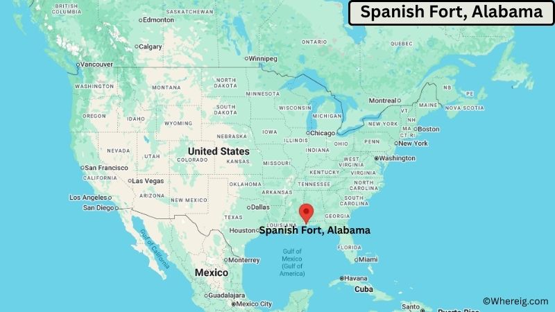
About Map: The map shows the location of Spanish Fort in Baldwin County, in the U.S. state of Alabama.
Spanish Fort Map, Alabama
About Spanish Fort Map: The Google Map highlights the location of Spanish Fort in Baldwin County, Alabama. Use the zoom, satellite, and street-view options to explore the city's neighborhoods, roads, and nearby places.
Where is Spanish Fort Located?
Spanish Fort is a city located in Baldwin County, Alabama, the United States. It lies on the eastern shore of Mobile Bay, about 10 miles east of Mobile and roughly 45 miles northwest of Gulf Shores. Daphne borders Spanish Fort to the south, while Mobile lies across the bay to the west. The city is located at 30.6749° North latitude and 87.9153° West longitude. The 2020 Census recorded 10,049 residents. Spanish Fort covers about 33.5 square miles (86.8 square kilometers), including land and water. The city occupies a strategic position near the mouth of the Mobile-Tensaw River Delta, where rivers, wetlands, and Mobile Bay meet. The area has a long military history, and Spanish Fort was the site of major fighting during the final stages of the American Civil War in 1865. Historic Spanish Fort and the nearby Five Rivers Alabama Delta Resource Center highlight the region's natural and cultural heritage. A unique feature of Spanish Fort is its elevated position along the eastern side of Mobile Bay, offering access to both coastal wetlands and the inland delta.
Most Viewed US Maps
| USA Sttae Map | USA Region Map | USA Road Map |
| USA County Map | Where is USA in World Map? | US ZIP Code Map |
| USA Time Zones Map | US State and Capitals Map | USA Physical Map |
Find 4,400+ U.S. Cities by State - Explore Their Locations and Get Detailed Information
Spanish Fort City Facts
| Fact | Details |
|---|---|
| City | Spanish Fort |
| State | Alabama |
| County | Baldwin County |
| Country | United States |
| Region | Alabama Gulf Coast, Mobile Bay |
| Incorporated | 1963 |
| Founded | 18th century |
| Total Area | 33.5 sq mi (86.8 sq km) |
| Land Area | 32.0 sq mi (82.9 sq km) |
| Water Area | 1.5 sq mi (3.9 sq km) |
| Elevation | About 50 ft (15 m) |
| Population (2023 estimate) | About 10,500 |
| Population (2020 Census) | 10,049 |
| Population Density | About 314 people per sq mi |
| Time Zone | Central Time (CST/CDT) |
| ZIP Codes | 36527 |
| Area Code | 251 |
| Major Highways | Interstate 10, U.S. Highway 31, U.S. Highway 98 |
| Public Transit | Baldwin Rural Area Transportation System and regional services |
| Major Attractions | Historic Blakeley State Park, Five Rivers Alabama Delta Resource Center, Spanish Fort Historic Site, Mobile-Tensaw Delta |
| Official Website | https://cityofspanishfort.com/ |
Distance from Spanish Fort, AL to Nearby Cities
- Daphne, AL – 3 miles (5 km)
- Malbis, AL – 5 miles (8 km)
- Mobile, AL – 10 miles (16 km)
- Fairhope, AL – 15 miles (24 km)
- Robertsdale, AL – 20 miles (32 km)
- Semmes, AL – 25 miles (40 km)
- Foley, AL – 30 miles (48 km)
- Bay Minette, AL – 25 miles (40 km)
- Gulf Shores, AL – 45 miles (72 km)
- Orange Beach, AL – 50 miles (80 km)
- Atmore, AL – 55 miles (89 km)
- Biloxi, MS – 65 miles (105 km)
- Hattiesburg, MS – 100 miles (161 km)
- Pensacola, FL – 55 miles (89 km)
- Milton, FL – 65 miles (105 km)
- Montgomery, AL – 180 miles (290 km)
- Birmingham, AL – 260 miles (418 km)
- New Orleans, LA – 145 miles (233 km)
Top Attractions in Spanish Fort, Alabama
- Historic Blakeley State Park – A large historic and natural park preserving the site of the 1814 Battle of Fort Blakeley and the 1865 Battle of Spanish Fort, with trails, wetlands, and historic landscapes.
- Five Rivers Alabama Delta Resource Center – A major nature and visitor center at the meeting point of five waterways, offering exhibits, trails, boat access, and views of the Mobile-Tensaw Delta.
- Spanish Fort Historic Site – A historic Civil War battlefield area connected to the 1865 Battle of Spanish Fort and the final campaigns of the conflict in Alabama.
- Mobile-Tensaw Delta – One of Alabama's largest wetland systems, providing habitat for birds, fish, alligators, and other wildlife and opportunities for boating and paddling.
- Mobile Bay – The bay provides scenic coastal views and supports boating, fishing, birdwatching, and other water-based activities.
- Meaher State Park – A nearby waterfront park on the Mobile-Tensaw Delta with camping, fishing, boating, boardwalks, and wildlife observation areas.
- Daphne Bayfront Park – A nearby waterfront park on Mobile Bay with walking areas, fishing access, picnic spaces, and views across the bay.
- Gulf State Park – A major coastal recreation area near Gulf Shores featuring beaches, trails, fishing, camping, and freshwater and saltwater habitats.
- USS Alabama Battleship Memorial Park – A major military museum across Mobile Bay featuring the battleship USS Alabama, aircraft, tanks, and other historic military equipment.
Airports Near Spanish Fort, Alabama
- Mobile Regional Airport (MOB) – 35 miles
- Mobile Downtown Airport (BFM) – 20 miles
- Pensacola International Airport (PNS) – 60 miles
- Gulfport-Biloxi International Airport (GPT) – 80 miles
Sources:
Population and area data sourced from the United States Census Bureau (2020 Census). General city information referenced from the official Spanish Fort city website and local government records.
Alabama Related Links
- Where is Alabaster
- Where is Albertville
- Where is Anniston
- Where is Athens
- Where is Auburn
- Where is Bessemer
- Where is Calera
- Where is Center Point
- Where is Chelsea
- Where is Cullman
- Where is Daphne
- Where is Decatur
- Where is Dothan
- Where is Enterprise
- Where is Fairhope
- Where is Florence
- Where is Foley
- Where is Fort Payne
- Where is Gadsden
- Where is Gardendale
- Where is Gulf Shores
- Where is Hartselle
- Where is Helena
- Where is Homewood
- Where is Hoover
- Where is Hueytown
- Where is Huntsville
- Where is Millbrook
- Where is Mobile
- Where is Mountain Brook
- Where is Muscle Shoals
- Where is Northport
- Where is Opelika
- Where is Oxford
- Where is Pelham
- Where is Phenix City
- Where is Prattville
- Where is Prichard
- Where is Saraland
- Where is Scottsboro
- Where is Selma
- Where is Talladega
- Where is Tillmans Corner
- Where is Troy
- Where is Trussville
- Where is Tuscaloosa
- Where is Vestavia Hills