
Where is Hueytown Located? - Hueytown is a city located in the Jefferson County of Alabama, United States. Hueytown lies between 58.3005 Degrees North latitudes and 134.4201 Degrees West longitudes.
Location Map of Hueytown, Alabama
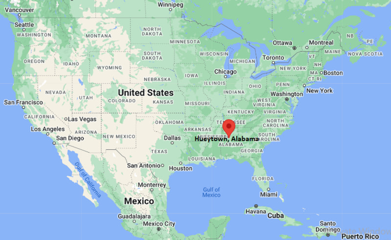
Hueytown Map, Alabama, USA
Where is Hueytown?: The Google Map showing the location of Hueytown in the U.S. state of Alabama.
Where is Hueytown Located?
Hueytown is a city located in the Jefferson County of Alabama, United States. Hueytown lies between 58.3005 Degrees North latitudes and 134.4201 Degrees West longitudes. According to 2020 U.S.census, the population of Hueytown city is 16776 people and the city has a total area of 19.68 sq mi. The city has numerous parks and recreational facilities.
Most Viewed US Maps
| USA Sttae Map | USA Region Map | USA Road Map |
| USA County Map | Where is USA in World Map? | US ZIP Code Map |
| USA Time Zones Map | US State and Capitals Map | USA Physical Map |
Find 4,400+ U.S. Cities by State - Explore Their Locations and Get Detailed Information
Hueytown, Alabama Quick Facts
| Property | Information |
|---|---|
| City | Hueytown |
| County | Jefferson County |
| State | Alabama |
| State Capital | Montgomery |
| US Region | Southern United States |
| Latitude | 33.4515° N |
| Longitude | 86.9967° W |
| Elevation | 528 ft (161 m) |
| Land Area | 7.15 sq mi |
| Water Area | 0.03 sq mi |
| Total Area | 7.18 sq mi |
| Population (latest Census year) | 16,105 (2020 Census) |
| Population Density | Approximately 2,252 per sq mi |
| ZIP Codes | 35023, 35061 |
| Area Code | 205, 659 |
| Time Zone Standard | Central Standard Time (CST, UTC−6) |
| Time Zone Daylight | Central Daylight Time (CDT, UTC−5) |
| Currency | US Dollar (USD) |
| FIPS Code | 01-37096 |
| Congressional District | Alabama's 7th Congressional District |
Nearby Cities to Hueytown, Alabama
- Bessemer, Alabama - South - 5 mi
- Pleasant Grove, Alabama - East - 4 mi
- Fairfield, Alabama - Northeast - 6 mi
- Birmingham, Alabama - Northeast - 12 mi
- Hoover, Alabama - Southeast - 15 mi
- Helena, Alabama - South - 17 mi
- Homewood, Alabama - East - 13 mi
- Vestavia Hills, Alabama - East - 16 mi
- Alabaster, Alabama - South - 23 mi
- Tuscaloosa, Alabama - West - 47 mi
Driving Distances from Hueytown, Alabama
| City | State | Distance (mi) | Approx. Drive Time |
|---|---|---|---|
| Pleasant Grove | Alabama | 4 | 8 minutes |
| Bessemer | Alabama | 5 | 10 minutes |
| Fairfield | Alabama | 6 | 12 minutes |
| Birmingham | Alabama | 12 | 18 minutes |
| Homewood | Alabama | 13 | 20 minutes |
| Hoover | Alabama | 15 | 22 minutes |
| Vestavia Hills | Alabama | 16 | 25 minutes |
| Helena | Alabama | 17 | 25 minutes |
| Alabaster | Alabama | 23 | 30 minutes |
| Tuscaloosa | Alabama | 47 | 50 minutes |
Transportation and Connectivity in Hueytown, Alabama
| Transportation | Details |
|---|---|
| Airport Name | Birmingham-Shuttlesworth International Airport |
| IATA Code | BHM |
| Port | Port Birmingham (nearby) |
| Major Highways | Interstate 20/59, Interstate 459 (nearby), Alabama State Route 5, Alabama State Route 150 |
| Train/Amtrak Service | Amtrak Crescent service available at Birmingham Station |
| Local Bus/Transit Service | Birmingham-Jefferson County Transit Authority (MAX Transit) |
- Interstate 20/59 provides direct access to Birmingham, Tuscaloosa, Meridian, and Atlanta via connecting highways.
- Interstate 459 offers a bypass around the Birmingham metropolitan area with connections to Interstate 65 and Interstate 59.
- Alabama State Route 5 links Hueytown with Bessemer, Birmingham, and neighboring Jefferson County communities.
- Alabama State Route 150 connects the city with Hoover, Bessemer, and commercial districts across western Jefferson County.
- Birmingham-Shuttlesworth International Airport, nearby Amtrak service, and MAX Transit provide convenient regional transportation options.
What are top Places to Visit in Hueytown, Alabama
| Landmark Name | Type |
|---|---|
| Hueytown Sports Complex | Sports Complex |
| Hueytown City Park | Community Park |
| Alabama Splash Adventure | Theme Park |
| Tannehill Ironworks Historical State Park | Historic State Park |
| Birmingham Civil Rights Institute | History Museum |
| Rickwood Field | Historic Ballpark |
| Red Mountain Park | Nature Park |
| Oak Mountain State Park | State Park |
| McWane Science Center | Science Museum |
| Railroad Park | Urban Park |
Colleges and Universities in Hueytown, Alabama
| Institution Name | Type | Level | Notable For |
|---|---|---|---|
| Jefferson State Community College | Public | Community College | Career training and university transfer programs |
| University of Alabama at Birmingham | Public | University | Medical research, engineering, and healthcare education |
| Samford University | Private | University | Business, law, pharmacy, and liberal arts |
| Miles College | Private | University | Liberal arts and historically Black education |
| Hueytown City School System | Public | K–12 District | Primary and secondary public education |
Waterbodies in Hueytown, Alabama
Valley Creek, Black Warrior River, Five Mile Creek, Shades Creek, Cahaba River, Lake Purdy, Warrior River Reservoir, Village Creek
Golf Courses in Hueytown, Alabama
Frank House Municipal Golf Course, Bent Brook Golf Course, Highland Park Golf Course, Ballantrae Golf Club, Robert Trent Jones Golf Trail at Oxmoor Valley, Timberline Golf Club
Hueytown, Alabama — Key Historical Facts
- Hueytown was incorporated in 1960 after growing from a small rural settlement into a thriving suburban community in western Jefferson County.
- The city's development was closely tied to the expansion of Birmingham's steel and mining industries, which attracted families seeking nearby residential neighborhoods.
- Hueytown gained national recognition as the hometown of the legendary Allison family, one of the most successful families in NASCAR history.
- During the late twentieth century, the city experienced steady residential and commercial growth because of its convenient access to Birmingham and Interstate highways.
- Today, Hueytown is known for its strong community spirit, local parks, racing heritage, and its role as an important suburb within the Birmingham metropolitan area.
References
Alabama Related Links
- Where is Alabaster
- Where is Albertville
- Where is Anniston
- Where is Athens
- Where is Auburn
- Where is Bessemer
- Where is Calera
- Where is Center Point
- Where is Chelsea
- Where is Cullman
- Where is Daphne
- Where is Decatur
- Where is Dothan
- Where is Enterprise
- Where is Fairhope
- Where is Florence
- Where is Foley
- Where is Fort Payne
- Where is Gadsden
- Where is Gardendale
- Where is Gulf Shores
- Where is Hartselle
- Where is Helena
- Where is Homewood
- Where is Hoover
- Where is Hueytown
- Where is Huntsville
- Where is Millbrook
- Where is Mobile
- Where is Mountain Brook
- Where is Muscle Shoals
- Where is Northport
- Where is Opelika
- Where is Oxford
- Where is Pelham
- Where is Phenix City
- Where is Prattville
- Where is Prichard
- Where is Saraland
- Where is Scottsboro
- Where is Selma
- Where is Talladega
- Where is Tillmans Corner
- Where is Troy
- Where is Trussville
- Where is Tuscaloosa
- Where is Vestavia Hills