
Where is Muscle Shoals Located? - Muscle Shoals is a city located in the Colbert County of Alabama, United States. Muscle Shoals lies between 34.6723 Degrees North latitudes and 86.0341 Degrees West longitudes.
Location Map of Muscle Shoals, Alabama
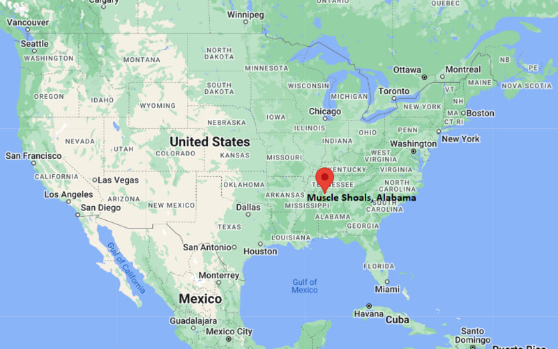
Muscle Shoals Map, Alabama, USA
Where is Muscle Shoals?: The Google Map showing the location of Muscle Shoals in the U.S. state of Alabama.
Where is Muscle Shoals Located?
Muscle Shoals is a city located in the Colbert County of Alabama, United States. Muscle Shoals lies between 34.6723 Degrees North latitudes and 86.0341 Degrees West longitudes. According to 2020 U.S.census, the population of Muscle Shoals city is 16275 people and the city has a total area of 16.54 sq mi. The city has numerous parks and recreational facilities.
Most Viewed US Maps
| USA Sttae Map | USA Region Map | USA Road Map |
| USA County Map | Where is USA in World Map? | US ZIP Code Map |
| USA Time Zones Map | US State and Capitals Map | USA Physical Map |
Find 4,400+ U.S. Cities by State - Explore Their Locations and Get Detailed Information
Muscle Shoals, Alabama Quick Facts
| Attribute | Information |
|---|---|
| City | Muscle Shoals |
| County | Colbert County |
| State | Alabama |
| State Capital | Montgomery |
| US Region | South (East South Central) |
| Latitude | 34.7448° N |
| Longitude | 87.6675° W |
| Elevation | 540 ft (165 m) |
| Land Area | 14.28 sq mi |
| Water Area | 0.31 sq mi |
| Total Area | 14.59 sq mi |
| Population (2020 Census) | 16,275 |
| Population Density | Approximately 1,140 per sq mi |
| ZIP Code | 35661 |
| Area Code | 256 |
| Time Zone Standard | Central Standard Time (CST, UTC−6) |
| Time Zone Daylight | Central Daylight Time (CDT, UTC−5) |
| Currency | United States Dollar (USD) |
| FIPS Code | 01-53016 |
| Congressional District | Alabama's 5th Congressional District |
Transportation and Connectivity in Muscle Shoals
| Category | Information |
|---|---|
| Airport Name | Northwest Alabama Regional Airport |
| IATA Code | MSL |
| Nearest Major Airport | Huntsville International Airport |
| Port | Tennessee River inland waterway access |
| Major Highways | U.S. Highway 43, U.S. Highway 72, Alabama Highway 157 |
| Train/Amtrak Service | Nearest Amtrak service available in Birmingham |
| Local Transit Service | Shoals Area Regional Transit System (SRTS) |
- U.S. Highway 72 – Major east–west route connecting Muscle Shoals with Huntsville and Memphis.
- U.S. Highway 43 – Important north–south highway serving northwest Alabama.
- Alabama Highway 157 – Regional route connecting Muscle Shoals with surrounding communities.
- Northwest Alabama Regional Airport provides commercial and general aviation services.
Top Places to Visit in Muscle Shoals, Alabama
| Landmark Name | Type |
|---|---|
| Fame Recording Studios | Music Historic Site |
| Muscle Shoals Sound Studio | Music Historic Site |
| Wilson Dam | Historic Dam and Recreation Area |
| River Heritage Park | Park and Riverfront Area |
| Spring Creek Golf Course | Golf Course |
| W.C. Handy Birthplace, Museum & Library | Museum |
| Alabama Music Hall of Fame | Music Museum |
| McFarland Park | Park and Campground |
| Pickwick Lake | Lake Recreation Area |
| Shiloh National Military Park | Historic Site |
Driving Distances from Muscle Shoals, Alabama to Nearby Cities
| City | State | Distance (mi) | Approx. Drive Time |
|---|---|---|---|
| Florence | Alabama | 5 | 10 minutes |
| Decatur | Alabama | 45 | 50 minutes |
| Huntsville | Alabama | 65 | 1 hour |
| Tupelo | Mississippi | 85 | 1 hour 30 minutes |
| Birmingham | Alabama | 115 | 2 hours |
| Memphis | Tennessee | 140 | 2 hours 15 minutes |
| Nashville | Tennessee | 120 | 2 hours |
| Atlanta | Georgia | 190 | 3 hours |
| Knoxville | Tennessee | 220 | 3 hours 30 minutes |
| Montgomery | Alabama | 220 | 3 hours 30 minutes |
Colleges and Universities Near Muscle Shoals, Alabama
| Institution Name | Type | Level | Notable For |
|---|---|---|---|
| University of North Alabama | Public | University | Business, education, nursing, arts, and sciences |
| Northwest-Shoals Community College | Public | Community College | Technical education, workforce training, and associate degrees |
| University of Alabama | Public | University | Research, engineering, business, and athletics |
| Alabama A&M University | Public | University | Agriculture, engineering, sciences, and education |
| Athens State University | Public | University | Education, business, and professional programs |
Waterbodies Near Muscle Shoals, Alabama
Tennessee River, Wilson Lake, Pickwick Lake, Spring Creek, Cypress Creek, and nearby waterways of the Tennessee River Valley.
Stadiums and Sports Facilities in Muscle Shoals
James F. Moore Stadium, Muscle Shoals High School athletic facilities, Northwest-Shoals Community College sports facilities, Spring Creek Golf Course, and local recreation complexes.
Muscle Shoals, Alabama — Key Historical Facts
- Muscle Shoals developed along the Tennessee River and has a long history connected to transportation, industry, and river commerce.
- The area was named after the natural rock formations and shallow areas, known as "shoals," found along the Tennessee River.
- The construction of Wilson Dam during the early twentieth century transformed the region by providing hydroelectric power and supporting industrial development.
- Muscle Shoals became internationally famous for its music heritage, especially the "Muscle Shoals Sound" created by recording studios and musicians during the twentieth century.
- The city became a center for recording artists across genres including soul, rock, country, and blues.
- Today, Muscle Shoals is known for its music history, Tennessee River recreation, manufacturing, and cultural attractions in northwest Alabama.
References
- City of Muscle Shoals
- Colbert County Government
- U.S. Census Bureau
- Alabama Music Hall of Fame
- Alabama Tourism
Alabama Related Links
- Where is Alabaster
- Where is Albertville
- Where is Anniston
- Where is Athens
- Where is Auburn
- Where is Bessemer
- Where is Calera
- Where is Center Point
- Where is Chelsea
- Where is Cullman
- Where is Daphne
- Where is Decatur
- Where is Dothan
- Where is Enterprise
- Where is Fairhope
- Where is Florence
- Where is Foley
- Where is Fort Payne
- Where is Gadsden
- Where is Gardendale
- Where is Gulf Shores
- Where is Hartselle
- Where is Helena
- Where is Homewood
- Where is Hoover
- Where is Hueytown
- Where is Huntsville
- Where is Millbrook
- Where is Mobile
- Where is Mountain Brook
- Where is Muscle Shoals
- Where is Northport
- Where is Opelika
- Where is Oxford
- Where is Pelham
- Where is Phenix City
- Where is Prattville
- Where is Prichard
- Where is Saraland
- Where is Scottsboro
- Where is Selma
- Where is Talladega
- Where is Tillmans Corner
- Where is Troy
- Where is Trussville
- Where is Tuscaloosa
- Where is Vestavia Hills