Map of Colbert County - Colbert County is a county located in the U.S. state of Alabama. Colbert County Map showing cities, highways, important places and water bodies. Get Where is Colbert County located in the map, major cities in Colbert county, population, areas, and places of interest.
Colbert County Map, Alabama
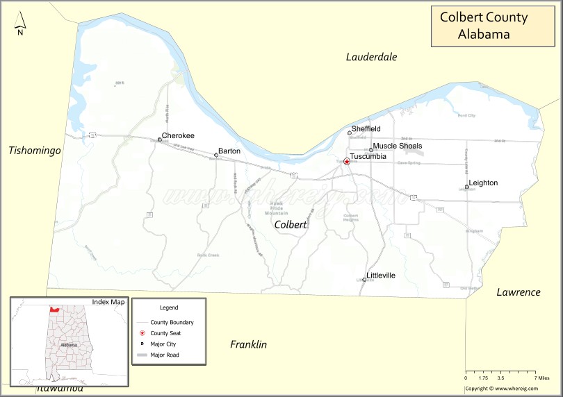
About Colbert County Map, Alabama: The map showing the county boundary, county seat, major cities, highways, water bodies and neighbouring counties.
Most Viewed Links
Map of Colbert County, Alabama
Colbert County is a county located in the U.S. state of Alabama. It`s county seat is Tuscumbia. As per 2020 census, the population of Colbert County was 57474 and population density of Colbert was 97square miles. According to the United States Census Bureau, the county has a total area of 592.62 sq mi (1,535 km2). Colbert County was established on 1867.
Colbert County Facts
| Continent | North America |
| Country | United States |
| State | Alabama |
| County Seat | Tuscumbia |
| Largest City/Town | Muscle Shoals |
| Established | February 6, 1867 |
| Total Area | 622 sq mi (1,611 sq km) |
| Land Area | 593 sq mi (1,536 sq km) |
| Water Area | 29 sq mi (75 sq km) |
| Population | 57,227 (Census 2020) |
| Population Density | 96.5 people per sq mi |
| Time Zone | Central Time Zone (CT) |
| Major Highways | US 43, US 72, US 72 Alternate, AL 20, AL 157, Natchez Trace Parkway |
| Major Rivers | Tennessee River |
| Neighboring Counties | Lauderdale County, Franklin County, Lawrence County, Tishomingo County (MS) |
| Famous For | Muscle Shoals music history, Tennessee River, recording studios, and the Shoals region |
| Top Attractions | FAME Studios, Muscle Shoals Sound Studio, Ivy Green, Alabama Music Hall of Fame, Tennessee River |
| Official Website | Official Website |
About Colbert County, Alabama
Colbert County is located in northwestern Alabama in the Shoals region and was established in 1867. The county seat is Tuscumbia, while Muscle Shoals is the largest city. The county sits along the Tennessee River and is internationally known for its influential music industry, historic recording studios, and scenic riverfront landscapes. :contentReference[oaicite:0]{index=0}
Cities and Towns in Colbert County, Alabama
| City/Town | Population (Census 2020) | Latitude & Longitude |
|---|---|---|
| Tuscumbia (county seat) | 9,554 | 34.7312°N, 87.7025°W |
| Muscle Shoals | 16,410 | 34.7448°N, 87.6675°W |
| Sheffield | 9,403 | 34.7581°N, 87.6986°W |
| Leighton | 665 | 34.7004°N, 87.5281°W |
| Cherokee | 970 | 34.7562°N, 87.9726°W |
| Littleville | 1,010 | 34.5904°N, 87.6767°W |
| Town Creek | 1,077 | 34.6812°N, 87.4065°W |
Best Golf Courses in Colbert County, Alabama
| Golf Course | Location | Latitude & Longitude |
|---|---|---|
| Robert Trent Jones Golf Trail at The Shoals - Fighting Joe Course | Muscle Shoals | 34.8024°N, 87.6484°W |
| Robert Trent Jones Golf Trail at The Shoals - Schoolmaster Course | Muscle Shoals | 34.8024°N, 87.6484°W |
| Muscle Shoals Country Club | Muscle Shoals | 34.7596°N, 87.6265°W |
| Cypress Lakes Golf & Tennis | Muscle Shoals | 34.7428°N, 87.6136°W |
| Tuscumbia Golf Course | Tuscumbia | 34.7279°N, 87.7061°W |
What are Major Roads and Highways in Colbert County
Major highways connect the county to nearby regions and cities.
- US Highway 43 - north-south route connecting Florence, Tuscumbia, Russellville, and Mobile
- US Highway 72 - major east-west corridor connecting the Shoals with Huntsville and Mississippi
- US Highway 72 Alternate - serves communities across the Shoals metropolitan area
- Alabama State Route 20 - connects Muscle Shoals with Decatur and western Alabama
- Alabama State Route 157 - links Colbert County with Moulton and Cullman areas
- Natchez Trace Parkway - scenic historic route crossing the county
Neighboring Counties of Colbert County
- Lauderdale County (north)
- Tishomingo County, Mississippi (northwest)
- Franklin County (west and southwest)
- Lawrence County (east)
What are Top Attractions in Colbert County, Alabama
The county offers a mix of natural and cultural attractions.
| Main Sight Name | City | Famous For |
|---|---|---|
| FAME Recording Studios | Muscle Shoals | Legendary recording studio where many famous artists recorded |
| Muscle Shoals Sound Studio | Sheffield | Historic music studio known worldwide |
| Ivy Green | Tuscumbia | Birthplace and childhood home of Helen Keller |
| Alabama Music Hall of Fame | Tuscumbia | Celebrates Alabama's music heritage |
| Spring Park | Tuscumbia | Historic park with fountains and family attractions |
| Tennessee River | Muscle Shoals | Boating, fishing, and scenic river views |
| The Shoals Theatre | Florence Area | Historic entertainment venue serving the Shoals region |
| Key Underwood Coon Dog Memorial Graveyard | Cherokee | Unique historic cemetery for hunting dogs |
| Natchez Trace Parkway | Countywide | Historic scenic driving route |
| ColdWater Books and Performing Arts Center | Tuscumbia | Local arts and cultural events |
| Wilson Lake | Muscle Shoals | Fishing, boating, and recreation |
| Colbert County Courthouse Square | Tuscumbia | Historic architecture and local heritage |
Distance from Colbert County to Nearby Cities
The following distances are measured by road (driving).
- Tuscumbia to Muscle Shoals (Colbert County), Alabama - 3 mi (5 km)
- Tuscumbia to Sheffield (Colbert County), Alabama - 2 mi (3 km)
- Tuscumbia to Leighton (Colbert County), Alabama - 11 mi (18 km)
- Tuscumbia to Cherokee (Colbert County), Alabama - 18 mi (29 km)
- Tuscumbia to Florence (Lauderdale County), Alabama - 7 mi (11 km)
- Tuscumbia to Russellville (Franklin County), Alabama - 23 mi (37 km)
- Tuscumbia to Moulton (Lawrence County), Alabama - 29 mi (47 km)
- Tuscumbia to Decatur (Morgan County), Alabama - 46 mi (74 km)
- Tuscumbia to Huntsville (Madison County), Alabama - 70 mi (113 km)
- Tuscumbia to Tupelo, Mississippi - 60 mi (97 km)
- Tuscumbia to Corinth, Mississippi - 46 mi (74 km)
- Tuscumbia to Birmingham (Jefferson County), Alabama - 118 mi (190 km)
- Tuscumbia to Nashville, Tennessee - 122 mi (196 km)
Nearest Airports
Nearest airport of Colbert is Northwest Alabama Regional Airport.
References
- QuickFacts - U.S. Census Bureau
- United States Census Bureau Profile
- United States Geological Survey (USGS)
- National Geodetic Survey
- Official County Website
- Autauga County Map
- Baldwin County Map
- Barbour County Map
- Bibb County Map
- Blount County Map
- Bullock County Map
- Butler County Map
- Calhoun County Map
- Chambers County Map
- Cherokee County Map
- Chilton County Map
- Choctaw County Map
- Clarke County Map
- Clay County Map
- Cleburne County Map
- Coffee County Map
- Colbert County Map
- Conecuh County Map
- Coosa County Map
- Covington County Map
- Crenshaw County Map
- Cullman County Map
- Dale County Map
- Dallas County Map
- DeKalb County Map
- Elmore County Map
- Escambia County Map
- Etowah County Map
- Fayette County Map
- Franklin County Map
- Geneva County Map
- Greene County Map
- Hale County Map
- Henry County Map
- Houston County Map
- Jackson County Map
- Jefferson County Map
- Lamar County Map
- Lauderdale County Map
- Lawrence County Map
- Lee County Map
- Limestone County Map
- Lowndes County Map
- Macon County Map
- Madison County Map
- Marengo County Map
- Marion County Map
- Marshall County Map
- Mobile County Map
- Monroe County Map
- Montgomery County Map
- Morgan County Map
- Perry County Map
- Pickens County Map
- Pike County Map
- Randolph County Map
- Russell County Map
- St Clair County Map
- Shelby County Map
- Sumter County Map
- Talladega County Map
- Tallapoosa County Map
- Tuscaloosa County Map
- Walker County Map
- Washington County Map
- Wilcox County Map
- Winston County Map
- Alabama Counties
- Alaska boroughs
- Arizona Counties
- Arkansas Counties
- California County Map
- Colorado Counties
- Connecticut Counties
- Delaware Counties
- Florida County Map
- Georgia County Map
- Hawaii Counties
- Idaho Counties
- Illinois Counties
- Indiana Counties
- Iowa Counties
- Kansas Counties
- Kentucky Counties
- Louisiana Counties
- Maine Counties
- Maryland Counties
- Massachusetts Counties
- Michigan County Map
- Minnesota Counties
- Mississippi Counties
- Missouri Counties
- Montana Counties
- Nebraska Counties
- Nevada Counties
- New York Counties
- New Hampshire Counties
- New Jersey Counties
- New Mexico Counties
- North Carolina Counties
- North Dakota Counties
- Ohio County Map
- Oklahoma Counties
- Oregon Counties
- Pennsylvania Counties
- Rhode Island Counties
- South Carolina Counties
- South Dakota Counties
- Map of Tennessee
- Texas County Map
- Utah Counties
- Vermont Counties
- Virginia Counties
- Washington Counties
- West Virginia Counties
- Wisconsin Counties
- Wyoming Counties