Map of Coosa County - Coosa County is a county located in the U.S. state of Alabama. Coosa County Map showing cities, highways, important places and water bodies. Get Where is Coosa County located in the map, major cities in Coosa county, population, areas, and places of interest.
Coosa County Map, Alabama
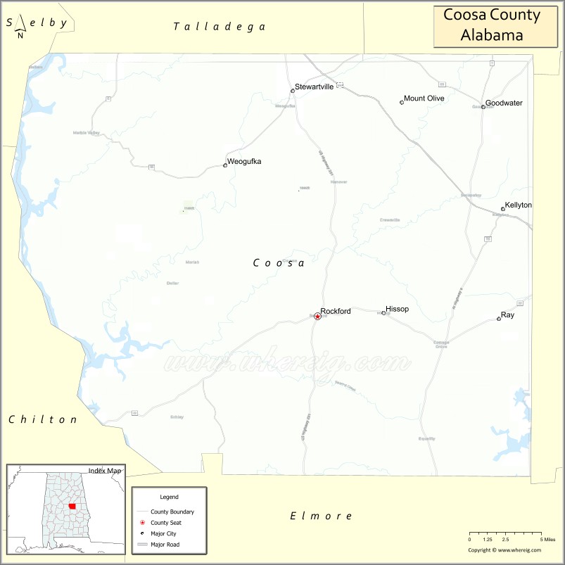
About Coosa County Map, Alabama: The map showing the county boundary, county seat, major cities, highways, water bodies and neighbouring counties.
Most Viewed Links
Map of Coosa County, Alabama
Coosa County is a county located in the U.S. state of Alabama. It`s county seat is Rockford. As per 2020 census, the population of Coosa County was 10450 and population density of Coosa was 16.1square miles. According to the United States Census Bureau, the county has a total area of 650.93 sq mi (1,686 km2). Coosa County was established on 1832.
Coosa County Facts
| Continent | North America |
| Country | United States |
| State | Alabama |
| County Seat | Rockford |
| Largest City/Town | Rockford |
| Established | December 18, 1832 |
| Total Area | 666 sq mi (1,725 sq km) |
| Land Area | 651 sq mi (1,686 sq km) |
| Water Area | 15 sq mi (39 sq km) |
| Population | 10,387 (Census 2020) |
| Population Density | 16 people per sq mi |
| Time Zone | Central Time Zone (CT) |
| Major Highways | US 231, AL 22, AL 9, AL 40, AL 259 |
| Major Rivers | Coosa River, Hatchet Creek, Weogufka Creek |
| Neighboring Counties | Talladega County, Clay County, Tallapoosa County, Elmore County, Chilton County, Shelby County |
| Famous For | Coosa River, Mitchell Lake, Lay Lake, rural scenery, and outdoor recreation |
| Top Attractions | Mitchell Lake, Coosa River, Hatchet Creek, Rockford Historic District, Weogufka Center for Arts and Culture |
| Official Website | Official Website |
About Coosa County, Alabama
Coosa County is located in east-central Alabama and was established in 1832. The county seat and largest incorporated town is Rockford. The county is known for its rolling hills, forested landscapes, scenic waterways, and abundant outdoor recreation opportunities centered around the Coosa River and its reservoirs.
Cities and Towns in Coosa County, Alabama
| City/Town | Population (Census 2020) | Latitude & Longitude |
|---|---|---|
| Rockford (county seat) | 346 | 32.8898°N, 86.2194°W |
| Goodwater | 1,291 | 33.0651°N, 86.0539°W |
| Kellyton | 217 | 32.9704°N, 86.0066°W |
| Equality (CDP) | 201 | 32.9047°N, 86.1106°W |
| Hissop (CDP) | 211 | 32.9965°N, 86.0491°W |
| Weogufka (CDP) | 282 | 32.9715°N, 86.3144°W |
Best Golf Courses in Coosa County, Alabama
| Golf Course | Location | Latitude & Longitude |
|---|---|---|
| Rockford Country Club | Rockford | 32.8878°N, 86.2245°W |
| Coosa Pines Golf Club | Goodwater Area | 33.0807°N, 86.0238°W |
What are Major Roads and Highways in Coosa County
Major highways connect the county to nearby regions and cities.
- US Highway 231 - major north-south route connecting the county with Montgomery and Talladega regions
- Alabama State Route 22 - east-west highway serving Rockford and connecting with Chilton and Tallapoosa counties
- Alabama State Route 9 - connects the county with Clay County and central Alabama communities
- Alabama State Route 40 - serves communities in the northeastern portion of the county
- Alabama State Route 259 - provides access to rural communities and recreation areas
Neighboring Counties of Coosa County
- Talladega County (north)
- Clay County (northeast)
- Tallapoosa County (east)
- Elmore County (south)
- Chilton County (west)
- Shelby County (northwest)
What are Top Attractions in Coosa County, Alabama
The county offers a mix of natural and cultural attractions.
| Main Sight Name | City | Famous For |
|---|---|---|
| Mitchell Lake | Western Coosa County | Boating, fishing, and waterfront recreation |
| Coosa River | Countywide | Scenic river views, fishing, and paddling |
| Hatchet Creek | Rockford Area | Kayaking, canoeing, and natural scenery |
| Weogufka Center for Arts and Culture | Weogufka | Local history and cultural events |
| Rockford Historic District | Rockford | Historic courthouse and architecture |
| Kellyton Public Boat Launch | Kellyton | Access to Lake Martin and Coosa River waters |
| Lay Lake Recreation Areas | Western County | Fishing, camping, and boating opportunities |
| Goodwater Historic Downtown | Goodwater | Historic buildings and small-town heritage |
| Hatchet Creek Falls Area | Rockford Area | Natural scenery and hiking opportunities |
| Coosa County Courthouse | Rockford | Historic county landmark |
| Weogufka Creek Scenic Area | Weogufka | Wildlife viewing and outdoor recreation |
| Flagg Mountain Trail Access | Northern County | Hiking and mountain scenery |
Distance from Coosa County to Nearby Cities
The following distances are measured by road (driving).
- Rockford to Goodwater (Coosa County), Alabama - 15 mi (24 km)
- Rockford to Kellyton (Coosa County), Alabama - 10 mi (16 km)
- Rockford to Alexander City (Tallapoosa County), Alabama - 21 mi (34 km)
- Rockford to Sylacauga (Talladega County), Alabama - 24 mi (39 km)
- Rockford to Childersburg (Talladega County), Alabama - 31 mi (50 km)
- Rockford to Clanton (Chilton County), Alabama - 33 mi (53 km)
- Rockford to Ashland (Clay County), Alabama - 26 mi (42 km)
- Rockford to Talladega (Talladega County), Alabama - 39 mi (63 km)
- Rockford to Wetumpka (Elmore County), Alabama - 42 mi (68 km)
- Rockford to Auburn (Lee County), Alabama - 53 mi (85 km)
- Rockford to Montgomery (Montgomery County), Alabama - 62 mi (100 km)
- Rockford to Birmingham (Jefferson County), Alabama - 68 mi (109 km)
- Rockford to Anniston (Calhoun County), Alabama - 63 mi (101 km)
References
- QuickFacts - U.S. Census Bureau
- United States Census Bureau
- United States Geological Survey (USGS)
- National Geodetic Survey
- Official County Website
- Autauga County Map
- Baldwin County Map
- Barbour County Map
- Bibb County Map
- Blount County Map
- Bullock County Map
- Butler County Map
- Calhoun County Map
- Chambers County Map
- Cherokee County Map
- Chilton County Map
- Choctaw County Map
- Clarke County Map
- Clay County Map
- Cleburne County Map
- Coffee County Map
- Colbert County Map
- Conecuh County Map
- Coosa County Map
- Covington County Map
- Crenshaw County Map
- Cullman County Map
- Dale County Map
- Dallas County Map
- DeKalb County Map
- Elmore County Map
- Escambia County Map
- Etowah County Map
- Fayette County Map
- Franklin County Map
- Geneva County Map
- Greene County Map
- Hale County Map
- Henry County Map
- Houston County Map
- Jackson County Map
- Jefferson County Map
- Lamar County Map
- Lauderdale County Map
- Lawrence County Map
- Lee County Map
- Limestone County Map
- Lowndes County Map
- Macon County Map
- Madison County Map
- Marengo County Map
- Marion County Map
- Marshall County Map
- Mobile County Map
- Monroe County Map
- Montgomery County Map
- Morgan County Map
- Perry County Map
- Pickens County Map
- Pike County Map
- Randolph County Map
- Russell County Map
- St Clair County Map
- Shelby County Map
- Sumter County Map
- Talladega County Map
- Tallapoosa County Map
- Tuscaloosa County Map
- Walker County Map
- Washington County Map
- Wilcox County Map
- Winston County Map
- Alabama Counties
- Alaska boroughs
- Arizona Counties
- Arkansas Counties
- California County Map
- Colorado Counties
- Connecticut Counties
- Delaware Counties
- Florida County Map
- Georgia County Map
- Hawaii Counties
- Idaho Counties
- Illinois Counties
- Indiana Counties
- Iowa Counties
- Kansas Counties
- Kentucky Counties
- Louisiana Counties
- Maine Counties
- Maryland Counties
- Massachusetts Counties
- Michigan County Map
- Minnesota Counties
- Mississippi Counties
- Missouri Counties
- Montana Counties
- Nebraska Counties
- Nevada Counties
- New York Counties
- New Hampshire Counties
- New Jersey Counties
- New Mexico Counties
- North Carolina Counties
- North Dakota Counties
- Ohio County Map
- Oklahoma Counties
- Oregon Counties
- Pennsylvania Counties
- Rhode Island Counties
- South Carolina Counties
- South Dakota Counties
- Map of Tennessee
- Texas County Map
- Utah Counties
- Vermont Counties
- Virginia Counties
- Washington Counties
- West Virginia Counties
- Wisconsin Counties
- Wyoming Counties