Map of Madison County - Madison County is a county located in the U.S. state of Alabama. Madison County Map showing cities, highways, important places and water bodies. Get Where is Madison County located in the map, major cities in Madison county, population, areas, and places of interest.
Madison County Map, Alabama
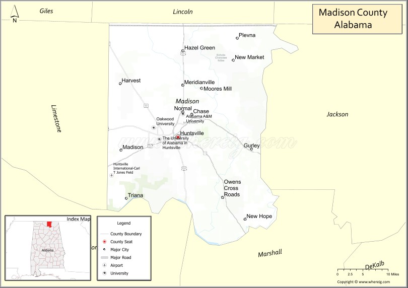
About Madison County Map, Alabama: The map showing the county boundary, county seat, major cities, highways, water bodies and neighbouring counties.
Most Viewed Links
Map of Madison County, Alabama
Madison County is a county located in the U.S. state of Alabama. It`s county seat is Huntsville. As per 2020 census, the population of Madison County was 395211 and population density of Madison was 493square miles. According to the United States Census Bureau, the county has a total area of 801.59 sq mi (2,076 km2). Madison County was established on 1808.
Madison County Facts
| Continent | North America |
| Country | United States |
| State | Alabama |
| County Seat | Huntsville |
| Largest City/Town | Huntsville |
| Established | December 13, 1808 |
| Total Area | 813 sq mi (2,106 sq km) |
| Land Area | 802 sq mi (2,077 sq km) |
| Water Area | 11 sq mi (29 sq km) |
| Population | 388,153 (Census 2020) |
| Population Density | 484 people per sq mi |
| Time Zone | Central Time Zone (CT) |
| Major Highways | Interstate 565, US 72, US 231, US 431, US 72 Alternate, AL 53, AL 255 |
| Major Rivers | Tennessee River, Flint River |
| Neighboring Counties | Limestone County, Morgan County, Marshall County, Jackson County, Lincoln County (TN) |
| Famous For | NASA, Redstone Arsenal, U.S. Space & Rocket Center, aerospace and technology industries |
| Top Attractions | U.S. Space & Rocket Center, Monte Sano State Park, Huntsville Botanical Garden, Burritt on the Mountain, and Bridge Street Town Centre |
| Official Website | Official Website |
About Madison County, Alabama
Madison County is located in northern Alabama along the Tennessee border and was established in 1808, making it one of the oldest counties in the state. The county seat and largest city is Huntsville. Madison County is the center of Alabama's aerospace, defense, and technology sectors and is home to Redstone Arsenal, NASA's Marshall Space Flight Center, and numerous research facilities. The county combines urban growth, advanced industry, mountain scenery, and outdoor recreation.
Cities and Towns in Madison County, Alabama
| City/Town | Population (Census 2020) | Latitude & Longitude |
|---|---|---|
| Huntsville (county seat) | 215,006 | 34.7304°N, 86.5861°W |
| Madison | 56,933 | 34.6993°N, 86.7483°W |
| New Hope | 2,889 | 34.5370°N, 86.3944°W |
| Owens Cross Roads | 2,120 | 34.5884°N, 86.4589°W |
| Gurley | 811 | 34.7012°N, 86.3722°W |
| Triana | 496 | 34.5862°N, 86.7414°W |
| New Market (CDP) | 1,597 | 34.9104°N, 86.4280°W |
| Meridianville (CDP) | 8,209 | 34.8687°N, 86.5730°W |
| Hazel Green (CDP) | 4,205 | 34.9312°N, 86.5716°W |
| Harvest (CDP) | 6,372 | 34.8554°N, 86.7503°W |
| Monrovia (CDP) | 10,757 | 34.7478°N, 86.7475°W |
| Chase (CDP) | 1,800 | 34.8254°N, 86.4767°W |
| Redstone Arsenal (CDP) | 1,946 | 34.6787°N, 86.6847°W |
| Ryland (CDP) | 1,967 | 34.8464°N, 86.4639°W |
Best Golf Courses in Madison County, Alabama
| Golf Course | Location | Latitude & Longitude |
|---|---|---|
| Robert Trent Jones Golf Trail at Hampton Cove - Highlands Course | Owens Cross Roads | 34.6447°N, 86.4868°W |
| Robert Trent Jones Golf Trail at Hampton Cove - River Course | Owens Cross Roads | 34.6447°N, 86.4868°W |
| Robert Trent Jones Golf Trail at Hampton Cove - Short Course | Owens Cross Roads | 34.6447°N, 86.4868°W |
| The Ledges | Huntsville | 34.6893°N, 86.4985°W |
| Valley Hill Country Club | Huntsville | 34.7068°N, 86.5938°W |
| Huntsville Country Club | Huntsville | 34.7118°N, 86.5874°W |
| Colonial Golf Course | Meridianville | 34.8826°N, 86.5788°W |
| Sunset Landing Golf Club | Madison | 34.6548°N, 86.6849°W |
| Canebrake Club | Athens-Madison Area | 34.7858°N, 86.9198°W |
What are Major Roads and Highways in Madison County
Major highways connect the county to nearby regions and cities.
- Interstate 565 - major expressway connecting Huntsville with Interstate 65 and Decatur
- US Highway 72 - east-west route connecting Huntsville with Athens and Scottsboro
- US Highway 231 - north-south highway linking Huntsville with Tennessee and Arab
- US Highway 431 - major route connecting Huntsville with Guntersville and Gadsden
- Alabama State Route 53 - serves northern Madison County communities
- Alabama State Route 255 - Research Park Boulevard connecting major employment centers
Neighboring Counties of Madison County
- Lincoln County, Tennessee (north)
- Jackson County (east)
- Marshall County (southeast)
- Morgan County (southwest)
- Limestone County (west)
What are Top Attractions in Madison County, Alabama
The county offers a mix of natural and cultural attractions.
| Main Sight Name | City | Famous For |
|---|---|---|
| U.S. Space & Rocket Center | Huntsville | World-famous space museum and rocket exhibits |
| NASA Marshall Space Flight Center | Huntsville | Historic and ongoing space exploration programs |
| Monte Sano State Park | Huntsville | Mountain views, hiking trails, and camping |
| Huntsville Botanical Garden | Huntsville | Large botanical collections and seasonal displays |
| Burritt on the Mountain | Huntsville | Historic mansion and mountain-top museum |
| Bridge Street Town Centre | Huntsville | Shopping, dining, and entertainment district |
| Big Spring International Park | Huntsville | Downtown landmark and event venue |
| EarlyWorks Children's Museum | Huntsville | Interactive family-oriented exhibits |
| Von Braun Center | Huntsville | Concerts, sports, and conventions |
| Cathedral Caverns State Park | Eastern County Area | Massive cave formations and guided tours |
| Hays Nature Preserve | Owens Cross Roads | Birdwatching and walking trails |
| Wheeler National Wildlife Refuge | Triana Area | Wildlife habitat and outdoor recreation |
Distance from Madison County to Nearby Cities
The following distances are measured by road (driving).
- Huntsville to Madison (Madison County), Alabama - 11 mi (18 km)
- Huntsville to Owens Cross Roads (Madison County), Alabama - 10 mi (16 km)
- Huntsville to Meridianville (Madison County), Alabama - 10 mi (16 km)
- Huntsville to Hazel Green (Madison County), Alabama - 15 mi (24 km)
- Huntsville to Athens (Limestone County), Alabama - 26 mi (42 km)
- Huntsville to Decatur (Morgan County), Alabama - 27 mi (43 km)
- Huntsville to Scottsboro (Jackson County), Alabama - 39 mi (63 km)
- Huntsville to Guntersville (Marshall County), Alabama - 38 mi (61 km)
- Huntsville to Fayetteville, Tennessee - 31 mi (50 km)
- Huntsville to Pulaski, Tennessee - 45 mi (72 km)
- Huntsville to Birmingham (Jefferson County), Alabama - 102 mi (164 km)
- Huntsville to Nashville, Tennessee - 110 mi (177 km)
- Huntsville to Chattanooga, Tennessee - 103 mi (166 km)
- Huntsville to Atlanta, Georgia - 185 mi (298 km)
Nearest Airports
Nearest airport of Madison is Huntsville International Airport.
References
- QuickFacts - U.S. Census Bureau
- United States Census Bureau
- United States Geological Survey (USGS)
- National Geodetic Survey
- Official County Website
- Autauga County Map
- Baldwin County Map
- Barbour County Map
- Bibb County Map
- Blount County Map
- Bullock County Map
- Butler County Map
- Calhoun County Map
- Chambers County Map
- Cherokee County Map
- Chilton County Map
- Choctaw County Map
- Clarke County Map
- Clay County Map
- Cleburne County Map
- Coffee County Map
- Colbert County Map
- Conecuh County Map
- Coosa County Map
- Covington County Map
- Crenshaw County Map
- Cullman County Map
- Dale County Map
- Dallas County Map
- DeKalb County Map
- Elmore County Map
- Escambia County Map
- Etowah County Map
- Fayette County Map
- Franklin County Map
- Geneva County Map
- Greene County Map
- Hale County Map
- Henry County Map
- Houston County Map
- Jackson County Map
- Jefferson County Map
- Lamar County Map
- Lauderdale County Map
- Lawrence County Map
- Lee County Map
- Limestone County Map
- Lowndes County Map
- Macon County Map
- Madison County Map
- Marengo County Map
- Marion County Map
- Marshall County Map
- Mobile County Map
- Monroe County Map
- Montgomery County Map
- Morgan County Map
- Perry County Map
- Pickens County Map
- Pike County Map
- Randolph County Map
- Russell County Map
- St Clair County Map
- Shelby County Map
- Sumter County Map
- Talladega County Map
- Tallapoosa County Map
- Tuscaloosa County Map
- Walker County Map
- Washington County Map
- Wilcox County Map
- Winston County Map
- Alabama Counties
- Alaska boroughs
- Arizona Counties
- Arkansas Counties
- California County Map
- Colorado Counties
- Connecticut Counties
- Delaware Counties
- Florida County Map
- Georgia County Map
- Hawaii Counties
- Idaho Counties
- Illinois Counties
- Indiana Counties
- Iowa Counties
- Kansas Counties
- Kentucky Counties
- Louisiana Counties
- Maine Counties
- Maryland Counties
- Massachusetts Counties
- Michigan County Map
- Minnesota Counties
- Mississippi Counties
- Missouri Counties
- Montana Counties
- Nebraska Counties
- Nevada Counties
- New York Counties
- New Hampshire Counties
- New Jersey Counties
- New Mexico Counties
- North Carolina Counties
- North Dakota Counties
- Ohio County Map
- Oklahoma Counties
- Oregon Counties
- Pennsylvania Counties
- Rhode Island Counties
- South Carolina Counties
- South Dakota Counties
- Map of Tennessee
- Texas County Map
- Utah Counties
- Vermont Counties
- Virginia Counties
- Washington Counties
- West Virginia Counties
- Wisconsin Counties
- Wyoming Counties