Map of Tallapoosa County - Tallapoosa County is a county located in the U.S. state of Alabama. Tallapoosa County Map showing cities, highways, important places and water bodies. Get Where is Tallapoosa County located in the map, major cities in Tallapoosa county, population, areas, and places of interest.
Tallapoosa County Map, Alabama
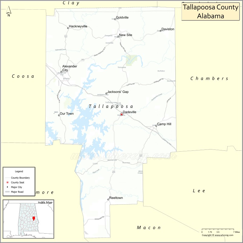
About Tallapoosa County Map, Alabama: The map showing the county boundary, county seat, major cities, highways, water bodies and neighbouring counties.
Most Viewed Links
Map of Tallapoosa County, Alabama
Tallapoosa County is a county located in the U.S. state of Alabama. It`s county seat is Dadeville. As per 2020 census, the population of Tallapoosa County was 41023 and population density of Tallapoosa was 57.3square miles. According to the United States Census Bureau, the county has a total area of 716.52 sq mi (1,856 km2). Tallapoosa County was established on 1832.
Tallapoosa County Facts
| Continent | North America |
| Country | United States |
| State | Alabama |
| County Seat | Dadeville |
| Largest City/Town | Alexander City |
| Established | December 18, 1832 |
| Total Area | 766 sq mi (1,984 sq km) |
| Land Area | 717 sq mi (1,857 sq km) |
| Water Area | 49 sq mi (127 sq km) |
| Population | 41,311 (Census 2020) |
| Population Density | 58 people per sq mi |
| Time Zone | Central Time Zone (CT) |
| Major Highways | US 280, AL 22, AL 49, AL 63, AL 128 |
| Major Rivers | Tallapoosa River, Little Tallapoosa River |
| Neighboring Counties | Elmore County, Coosa County, Clay County, Chambers County, Lee County, Macon County |
| Famous For | Lake Martin, Tallapoosa River, Russell Lands, and outdoor recreation |
| Top Attractions | Lake Martin, Wind Creek State Park, Horseshoe Bend National Military Park, Smith Mountain Fire Tower, and Wellborn MuscleCar Museum |
| Official Website | Official Website |
About Tallapoosa County, Alabama
Tallapoosa County is located in east-central Alabama and was established in 1832. The county seat is Dadeville, while Alexander City is the largest city. The county is best known for Lake Martin, one of the largest man-made lakes in the United States. Scenic forests, rolling hills, river valleys, and waterfront communities make Tallapoosa County a major destination for recreation, tourism, and outdoor activities.
Cities and Towns in Tallapoosa County, Alabama
| City/Town | Population (Census 2020) | Latitude & Longitude |
|---|---|---|
| Dadeville (county seat) | 3,230 | 32.8312°N, 85.7641°W |
| Alexander City | 14,843 | 32.9440°N, 85.9539°W |
| Camp Hill | 1,006 | 32.8007°N, 85.6536°W |
| Daviston | 214 | 33.0584°N, 85.7919°W |
| New Site | 430 | 32.9737°N, 85.7811°W |
| Jacksons' Gap | 630 | 32.8864°N, 85.8658°W |
| Goldville | 47 | 32.9497°N, 85.7884°W |
| Reeltown (CDP) | 377 | 32.8148°N, 85.8395°W |
| Blue Creek (CDP) | 318 | 32.8824°N, 85.9442°W |
| Suscapaw (CDP) | 145 | 32.9038°N, 85.7176°W |
Best Golf Courses in Tallapoosa County, Alabama
| Golf Course | Location | Latitude & Longitude |
|---|---|---|
| Willow Point Golf & Country Club | Alexander City | 32.8637°N, 85.8975°W |
| Wicker Point Golf Club | Alexander City | 32.8382°N, 85.8768°W |
| The Ridge Golf Course | Alexander City | 32.8257°N, 85.8783°W |
| Lakewinds Golf Course | Dadeville | 32.8329°N, 85.7756°W |
| Cider Ridge at Lake Martin | Jacksons' Gap | 32.9031°N, 85.8789°W |
| StillWaters Golf Club | Dadeville | 32.7375°N, 85.8198°W |
What are Major Roads and Highways in Tallapoosa County
Major highways connect the county to nearby regions and cities.
- US Highway 280 - major east-west corridor connecting Alexander City with Birmingham and Auburn
- Alabama State Route 22 - serves Alexander City and western parts of the county
- Alabama State Route 49 - connects Dadeville with Auburn and Lake Martin communities
- Alabama State Route 63 - major route serving Lake Martin and Alexander City
- Alabama State Route 128 - provides access to Wind Creek State Park and Lake Martin areas
Neighboring Counties of Tallapoosa County
- Coosa County (northwest)
- Elmore County (west)
- Macon County (southwest)
- Lee County (south)
- Chambers County (east)
- Clay County (north)
What are Top Attractions in Tallapoosa County, Alabama
The county offers a mix of natural and cultural attractions.
| Main Sight Name | City | Famous For |
|---|---|---|
| Lake Martin | Alexander City Area | Boating, fishing, swimming, and waterfront recreation |
| Wind Creek State Park | Alexander City | Camping, hiking, and lake access |
| Horseshoe Bend National Military Park | Dadeville Area | Historic War of 1812 battlefield |
| Smith Mountain Fire Tower | Dadeville | Panoramic views of Lake Martin and surrounding hills |
| Wellborn MuscleCar Museum | Alexander City | Rare American muscle car collection |
| Cherokee Ridge Alpine Trail | Lake Martin Area | Scenic hiking trails and overlooks |
| Kowaliga Bridge Area | Dadeville | Popular Lake Martin landmark |
| Russell Crossroads | Alexander City Area | Shopping, dining, and community events |
| StillWaters Resort | Dadeville | Golf, lodging, and lakeside recreation |
| Lake Martin Amphitheater | Dadeville | Concerts and outdoor entertainment |
| Alexander City Historic Downtown | Alexander City | Historic architecture and local businesses |
| Tallapoosa River Valley | Countywide | Scenic landscapes and wildlife viewing |
| Jacksons' Gap Heritage Area | Jacksons' Gap | Local history and community events |
| Camp Hill Historic District | Camp Hill | Historic rural Alabama heritage |
Distance from Tallapoosa County to Nearby Cities
The following distances are measured by road (driving).
- Dadeville to Alexander City (Tallapoosa County), Alabama - 13 mi (21 km)
- Dadeville to Camp Hill (Tallapoosa County), Alabama - 9 mi (14 km)
- Dadeville to Jacksons' Gap (Tallapoosa County), Alabama - 10 mi (16 km)
- Dadeville to New Site (Tallapoosa County), Alabama - 18 mi (29 km)
- Dadeville to Auburn (Lee County), Alabama - 25 mi (40 km)
- Dadeville to Opelika (Lee County), Alabama - 29 mi (47 km)
- Dadeville to Tuskegee (Macon County), Alabama - 23 mi (37 km)
- Dadeville to Rockford (Coosa County), Alabama - 32 mi (51 km)
- Dadeville to Lafayette (Chambers County), Alabama - 31 mi (50 km)
- Dadeville to Wetumpka (Elmore County), Alabama - 39 mi (63 km)
- Dadeville to Montgomery (Montgomery County), Alabama - 54 mi (87 km)
- Dadeville to Birmingham (Jefferson County), Alabama - 84 mi (135 km)
- Dadeville to Columbus, Georgia - 65 mi (105 km)
- Dadeville to Atlanta, Georgia - 108 mi (174 km)
- Dadeville to Huntsville (Madison County), Alabama - 162 mi (261 km)
Nearest Airports
Nearest airport of Tallapoosa is Hartsfield–Jackson Atlanta International Airport (ATL).
References
- QuickFacts - U.S. Census Bureau
- United States Census Bureau
- United States Geological Survey (USGS)
- National Geodetic Survey
- Official County Website
- Autauga County Map
- Baldwin County Map
- Barbour County Map
- Bibb County Map
- Blount County Map
- Bullock County Map
- Butler County Map
- Calhoun County Map
- Chambers County Map
- Cherokee County Map
- Chilton County Map
- Choctaw County Map
- Clarke County Map
- Clay County Map
- Cleburne County Map
- Coffee County Map
- Colbert County Map
- Conecuh County Map
- Coosa County Map
- Covington County Map
- Crenshaw County Map
- Cullman County Map
- Dale County Map
- Dallas County Map
- DeKalb County Map
- Elmore County Map
- Escambia County Map
- Etowah County Map
- Fayette County Map
- Franklin County Map
- Geneva County Map
- Greene County Map
- Hale County Map
- Henry County Map
- Houston County Map
- Jackson County Map
- Jefferson County Map
- Lamar County Map
- Lauderdale County Map
- Lawrence County Map
- Lee County Map
- Limestone County Map
- Lowndes County Map
- Macon County Map
- Madison County Map
- Marengo County Map
- Marion County Map
- Marshall County Map
- Mobile County Map
- Monroe County Map
- Montgomery County Map
- Morgan County Map
- Perry County Map
- Pickens County Map
- Pike County Map
- Randolph County Map
- Russell County Map
- St Clair County Map
- Shelby County Map
- Sumter County Map
- Talladega County Map
- Tallapoosa County Map
- Tuscaloosa County Map
- Walker County Map
- Washington County Map
- Wilcox County Map
- Winston County Map
- Alabama Counties
- Alaska boroughs
- Arizona Counties
- Arkansas Counties
- California County Map
- Colorado Counties
- Connecticut Counties
- Delaware Counties
- Florida County Map
- Georgia County Map
- Hawaii Counties
- Idaho Counties
- Illinois Counties
- Indiana Counties
- Iowa Counties
- Kansas Counties
- Kentucky Counties
- Louisiana Counties
- Maine Counties
- Maryland Counties
- Massachusetts Counties
- Michigan County Map
- Minnesota Counties
- Mississippi Counties
- Missouri Counties
- Montana Counties
- Nebraska Counties
- Nevada Counties
- New York Counties
- New Hampshire Counties
- New Jersey Counties
- New Mexico Counties
- North Carolina Counties
- North Dakota Counties
- Ohio County Map
- Oklahoma Counties
- Oregon Counties
- Pennsylvania Counties
- Rhode Island Counties
- South Carolina Counties
- South Dakota Counties
- Map of Tennessee
- Texas County Map
- Utah Counties
- Vermont Counties
- Virginia Counties
- Washington Counties
- West Virginia Counties
- Wisconsin Counties
- Wyoming Counties