Map of Sumter County - Sumter County is a county located in the U.S. state of Alabama. Sumter County Map showing cities, highways, important places and water bodies. Get Where is Sumter County located in the map, major cities in Sumter county, population, areas, and places of interest.
Sumter County Map, Alabama
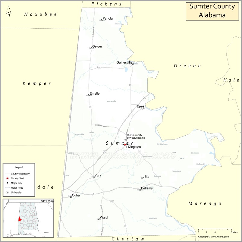
About Sumter County Map, Alabama: The map showing the county boundary, county seat, major cities, highways, water bodies and neighbouring counties.
Most Viewed Links
Map of Sumter County, Alabama
Sumter County is a county located in the U.S. state of Alabama. It`s county seat is Livingston. As per 2020 census, the population of Sumter County was 12164 and population density of Sumter was 13.5square miles. According to the United States Census Bureau, the county has a total area of 903.89 sq mi (2,341 km2). Sumter County was established on 1832.
Sumter County Facts
| Continent | North America |
| Country | United States |
| State | Alabama |
| County Seat | Livingston |
| Largest City/Town | Livingston |
| Established | December 18, 1832 |
| Total Area | 913 sq mi (2,365 sq km) |
| Land Area | 904 sq mi (2,341 sq km) |
| Water Area | 9 sq mi (23 sq km) |
| Population | 12,345 (Census 2020) |
| Population Density | 14 people per sq mi |
| Time Zone | Central Time Zone (CT) |
| Major Highways | US 11, US 80, AL 17, AL 28, AL 39 |
| Major Rivers | Tombigbee River, Sucarnoochee River |
| Neighboring Counties | Pickens County, Greene County, Marengo County, Choctaw County, Lauderdale County (MS), Kemper County (MS) |
| Famous For | University of West Alabama, Tombigbee River, Civil War history, and Alabama Black Belt heritage |
| Top Attractions | University of West Alabama, Gainesville Historic District, Lake LU, Tombigbee River, and Livingston Courthouse Square |
| Official Website | Official Website |
About Sumter County, Alabama
Sumter County is located in west-central Alabama along the Mississippi state line and was established in 1832. The county seat and largest city is Livingston. The county is part of Alabama's historic Black Belt region and is home to the University of West Alabama. Fertile agricultural lands, the Tombigbee River, and a rich cultural history make Sumter County an important part of western Alabama.
Cities and Towns in Sumter County, Alabama
| City/Town | Population (Census 2020) | Latitude & Longitude |
|---|---|---|
| Livingston (county seat) | 3,425 | 32.5846°N, 88.1875°W |
| York | 2,114 | 32.4860°N, 88.2961°W |
| Cuba | 297 | 32.4304°N, 88.3775°W |
| Emelle | 56 | 32.7304°N, 88.3134°W |
| Gainesville | 208 | 32.8160°N, 88.1589°W |
| Geiger | 95 | 32.8748°N, 88.2875°W |
| Panola (CDP) | 112 | 32.6796°N, 88.0435°W |
| Bellamy (CDP) | 543 | 32.4974°N, 88.1330°W |
| Ward (CDP) | 171 | 32.6492°N, 88.2780°W |
| Whitfield (CDP) | 124 | 32.5605°N, 88.0798°W |
Best Golf Courses in Sumter County, Alabama
| Golf Course | Location | Latitude & Longitude |
|---|---|---|
| Rooster Ridge Golf Course | Livingston | 32.5952°N, 88.1809°W |
| University of West Alabama Golf Practice Facility | Livingston | 32.5881°N, 88.1864°W |
| York Community Golf Course | York | 32.4907°N, 88.2946°W |
What are Major Roads and Highways in Sumter County
Major highways connect the county to nearby regions and cities.
- US Highway 11 - north-south route connecting Livingston, York, and Mississippi communities
- US Highway 80 - major east-west highway crossing southern Sumter County
- Alabama State Route 17 - links Livingston with Pickens and Greene counties
- Alabama State Route 28 - crosses central portions of the county
- Alabama State Route 39 - serves western Sumter County and connects to Mississippi
Neighboring Counties of Sumter County
- Pickens County (north)
- Greene County (east)
- Marengo County (southeast)
- Choctaw County (south)
- Kemper County, Mississippi (west)
- Lauderdale County, Mississippi (northwest)
What are Top Attractions in Sumter County, Alabama
The county offers a mix of natural and cultural attractions.
| Main Sight Name | City | Famous For |
|---|---|---|
| University of West Alabama | Livingston | Historic public university founded in 1835 |
| Lake LU | Livingston | Fishing, boating, and outdoor recreation |
| Livingston Courthouse Square | Livingston | Historic downtown and local events |
| Gainesville Historic District | Gainesville | Antebellum architecture and Alabama history |
| Tombigbee River | Countywide | Boating, fishing, and wildlife viewing |
| York Historic District | York | Historic churches and downtown buildings |
| Jaycee Neighborhood Park | Livingston | Family recreation and community events |
| University of West Alabama Nature Trails | Livingston | Walking trails and wildlife observation |
| Emelle Scenic Countryside | Emelle | Black Belt landscapes and rural scenery |
| Cuba Historic Area | Cuba | Historic railroad-era heritage |
| Bellamy River Access | Bellamy | Fishing and Tombigbee River access |
| Geiger Heritage Area | Geiger | Historic small-town Alabama culture |
Distance from Sumter County to Nearby Cities
The following distances are measured by road (driving).
- Livingston to York (Sumter County), Alabama - 8 mi (13 km)
- Livingston to Cuba (Sumter County), Alabama - 14 mi (23 km)
- Livingston to Gainesville (Sumter County), Alabama - 17 mi (27 km)
- Livingston to Emelle (Sumter County), Alabama - 14 mi (23 km)
- Livingston to Carrollton (Pickens County), Alabama - 28 mi (45 km)
- Livingston to Eutaw (Greene County), Alabama - 35 mi (56 km)
- Livingston to Demopolis (Marengo County), Alabama - 38 mi (61 km)
- Livingston to Butler (Choctaw County), Alabama - 39 mi (63 km)
- Livingston to Meridian, Mississippi - 35 mi (56 km)
- Livingston to Columbus, Mississippi - 58 mi (93 km)
- Livingston to Tuscaloosa (Tuscaloosa County), Alabama - 64 mi (103 km)
- Livingston to Starkville, Mississippi - 72 mi (116 km)
- Livingston to Birmingham (Jefferson County), Alabama - 119 mi (191 km)
- Livingston to Montgomery (Montgomery County), Alabama - 132 mi (212 km)
- Livingston to Mobile (Mobile County), Alabama - 168 mi (270 km)
Nearest Airports
Nearest airport of Sumter is Sumter Airport-Sms.
References
- QuickFacts - U.S. Census Bureau
- United States Census Bureau
- United States Geological Survey (USGS)
- National Geodetic Survey
- Official County Website
- Autauga County Map
- Baldwin County Map
- Barbour County Map
- Bibb County Map
- Blount County Map
- Bullock County Map
- Butler County Map
- Calhoun County Map
- Chambers County Map
- Cherokee County Map
- Chilton County Map
- Choctaw County Map
- Clarke County Map
- Clay County Map
- Cleburne County Map
- Coffee County Map
- Colbert County Map
- Conecuh County Map
- Coosa County Map
- Covington County Map
- Crenshaw County Map
- Cullman County Map
- Dale County Map
- Dallas County Map
- DeKalb County Map
- Elmore County Map
- Escambia County Map
- Etowah County Map
- Fayette County Map
- Franklin County Map
- Geneva County Map
- Greene County Map
- Hale County Map
- Henry County Map
- Houston County Map
- Jackson County Map
- Jefferson County Map
- Lamar County Map
- Lauderdale County Map
- Lawrence County Map
- Lee County Map
- Limestone County Map
- Lowndes County Map
- Macon County Map
- Madison County Map
- Marengo County Map
- Marion County Map
- Marshall County Map
- Mobile County Map
- Monroe County Map
- Montgomery County Map
- Morgan County Map
- Perry County Map
- Pickens County Map
- Pike County Map
- Randolph County Map
- Russell County Map
- St Clair County Map
- Shelby County Map
- Sumter County Map
- Talladega County Map
- Tallapoosa County Map
- Tuscaloosa County Map
- Walker County Map
- Washington County Map
- Wilcox County Map
- Winston County Map
- Alabama Counties
- Alaska boroughs
- Arizona Counties
- Arkansas Counties
- California County Map
- Colorado Counties
- Connecticut Counties
- Delaware Counties
- Florida County Map
- Georgia County Map
- Hawaii Counties
- Idaho Counties
- Illinois Counties
- Indiana Counties
- Iowa Counties
- Kansas Counties
- Kentucky Counties
- Louisiana Counties
- Maine Counties
- Maryland Counties
- Massachusetts Counties
- Michigan County Map
- Minnesota Counties
- Mississippi Counties
- Missouri Counties
- Montana Counties
- Nebraska Counties
- Nevada Counties
- New York Counties
- New Hampshire Counties
- New Jersey Counties
- New Mexico Counties
- North Carolina Counties
- North Dakota Counties
- Ohio County Map
- Oklahoma Counties
- Oregon Counties
- Pennsylvania Counties
- Rhode Island Counties
- South Carolina Counties
- South Dakota Counties
- Map of Tennessee
- Texas County Map
- Utah Counties
- Vermont Counties
- Virginia Counties
- Washington Counties
- West Virginia Counties
- Wisconsin Counties
- Wyoming Counties