Map of Winston County - Winston County is a county located in the U.S. state of Alabama. Winston County Map showing cities, highways, important places and water bodies. Get Where is Winston County located in the map, major cities in Winston county, population, areas, and places of interest.
Winston County Map, Alabama
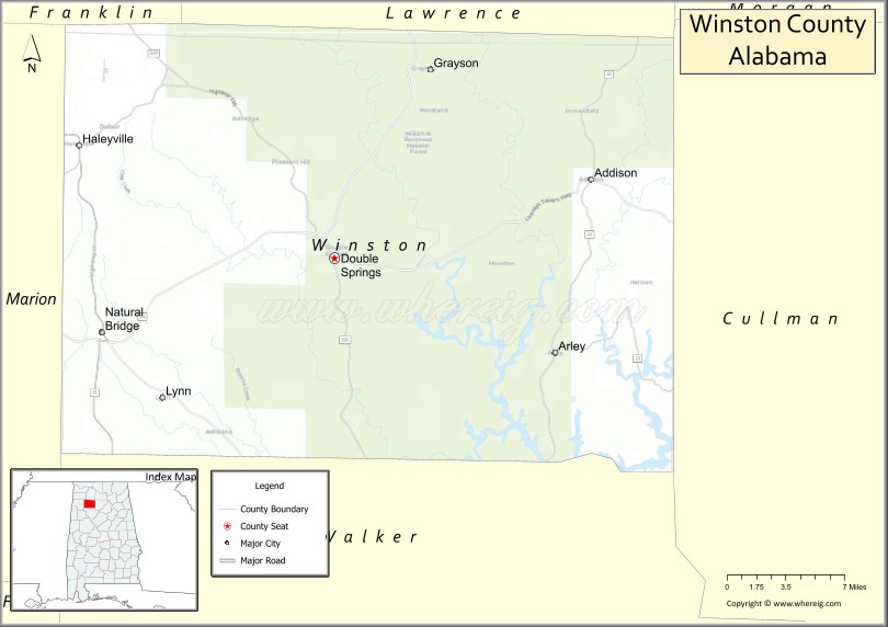
About Winston County Map, Alabama: The map showing the county boundary, county seat, major cities, highways, water bodies and neighbouring counties.
Most Viewed Links
Map of Winston County, Alabama
Winston County is a county located in the U.S. state of Alabama. It`s county seat is Double Springs. As per 2020 census, the population of Winston County was 23652 and population density of Winston was 38.6square miles. According to the United States Census Bureau, the county has a total area of 612.98 sq mi (1,588 km2). Winston County was established on 1850.
Winston County Facts
| Continent | North America |
| Country | United States |
| State | Alabama |
| County Seat | Double Springs |
| Largest City/Town | Haleyville |
| Established | February 12, 1850 |
| Total Area | 632 sq mi (1,637 sq km) |
| Land Area | 613 sq mi (1,588 sq km) |
| Water Area | 19 sq mi (49 sq km) |
| Population | 23,540 (Census 2020) |
| Population Density | 38 people per sq mi |
| Time Zone | Central Time Zone (CT) |
| Major Highways | US 278, AL 5, AL 13, AL 33, AL 129, AL 195, AL 243 |
| Major Rivers | Sipsey Fork, Blackwater Creek |
| Neighboring Counties | Lawrence County, Cullman County, Walker County, Marion County, Franklin County |
| Famous For | The Free State of Winston, Bankhead National Forest, Lewis Smith Lake, and Civil War history |
| Top Attractions | Bankhead National Forest, Lewis Smith Lake, Natural Bridge Park, Houston Historic Jail, and Looney's Amphitheater |
| Official Website | Official Website |
About Winston County, Alabama
Winston County is located in northwestern Alabama and was established in 1850. The county seat is Double Springs, while Haleyville is the largest city. Known as the "Free State of Winston," the county gained national attention for its opposition to secession during the Civil War. Forested mountains, lakes, and scenic valleys make the county a popular destination for outdoor recreation and tourism. :contentReference[oaicite:0]{index=0}
Cities and Towns in Winston County, Alabama
| City/Town | Population (Census 2020) | Latitude & Longitude |
|---|---|---|
| Double Springs (county seat) | 1,083 | 34.1462°N, 87.4028°W |
| Haleyville | 4,248 | 34.2265°N, 87.6214°W |
| Addison | 659 | 34.2026°N, 87.1814°W |
| Arley | 357 | 34.0787°N, 87.2134°W |
| Lynn | 597 | 34.0478°N, 87.5498°W |
| Natural Bridge | 37 | 34.0934°N, 87.6169°W |
| Nauvoo (partly in Walker County) | 221 | 33.9900°N, 87.4878°W |
Best Golf Courses in Winston County, Alabama
| Golf Course | Location | Latitude & Longitude |
|---|---|---|
| Arrowhead Landing Golf Course | Addison | 34.1377°N, 87.3008°W |
| Twin Forks Golf Club | Arley | 34.0759°N, 87.2147°W |
| Haleyville Country Club | Haleyville | 34.2339°N, 87.6248°W |
What are Major Roads and Highways in Winston County
Major highways connect the county to nearby regions and cities.
- US Highway 278 - east-west route connecting Double Springs, Cullman, and Hamilton
- Alabama State Route 5 - north-south route linking Haleyville with Jasper and Florence
- Alabama State Route 13 - connects Haleyville with Russellville and Jasper
- Alabama State Route 33 - provides access to Bankhead National Forest and Moulton
- Alabama State Route 129 - serves communities in the western part of the county
- Alabama State Route 195 - connects Double Springs with Haleyville
- Alabama State Route 243 - links the county with Lawrence County
Neighboring Counties of Winston County
- Lawrence County (north)
- Cullman County (east)
- Walker County (south)
- Marion County (west)
- Franklin County (northwest)
What are Top Attractions in Winston County, Alabama
The county offers a mix of natural and cultural attractions.
| Main Sight Name | City | Famous For |
|---|---|---|
| Bankhead National Forest | Double Springs Area | Hiking trails, waterfalls, camping, and wilderness scenery |
| Lewis Smith Lake | Arley | Boating, fishing, swimming, and waterfront recreation |
| Natural Bridge Park | Natural Bridge | One of the longest natural bridges east of the Rocky Mountains |
| Houston Historic Jail | Houston | Historic Civil War-era jail and museum |
| Looney's Amphitheater | Double Springs | Outdoor music and entertainment venue |
| Free State of Winston Museum | Double Springs | Civil War and county history exhibits |
| Sipsey Wilderness | Bankhead National Forest | Backpacking, waterfalls, and nature photography |
| Kinlock Falls | Double Springs Area | Popular waterfall and swimming area |
| Smith Lake Dam Overlook | Arley Area | Scenic lake and river views |
| Double Springs Historic District | Double Springs | Historic courthouse and downtown architecture |
| Dismals Branch Recreation Area | Haleyville Area | Forest scenery and outdoor recreation |
| William B. Bankhead Forest Trails | Countywide | Hiking and wildlife viewing |
Distance from Winston County to Nearby Cities
The following distances are measured by road (driving).
- Double Springs to Haleyville (Winston County), Alabama - 16 mi (26 km)
- Double Springs to Addison (Winston County), Alabama - 14 mi (23 km)
- Double Springs to Arley (Winston County), Alabama - 12 mi (19 km)
- Double Springs to Lynn (Winston County), Alabama - 17 mi (27 km)
- Double Springs to Natural Bridge (Winston County), Alabama - 18 mi (29 km)
- Double Springs to Moulton (Lawrence County), Alabama - 28 mi (45 km)
- Double Springs to Cullman (Cullman County), Alabama - 39 mi (63 km)
- Double Springs to Jasper (Walker County), Alabama - 30 mi (48 km)
- Double Springs to Hamilton (Marion County), Alabama - 27 mi (43 km)
- Double Springs to Russellville (Franklin County), Alabama - 33 mi (53 km)
- Double Springs to Decatur (Morgan County), Alabama - 49 mi (79 km)
- Double Springs to Florence (Lauderdale County), Alabama - 54 mi (87 km)
- Double Springs to Huntsville (Madison County), Alabama - 72 mi (116 km)
- Double Springs to Birmingham (Jefferson County), Alabama - 72 mi (116 km)
- Double Springs to Tupelo, Mississippi - 87 mi (140 km)
Nearest Airports
Nearest airport of Winston is Double Springs–Winston County Airport
References
- QuickFacts - U.S. Census Bureau
- United States Census Bureau
- United States Geological Survey (USGS)
- National Geodetic Survey
- Official Winston County Website
- Autauga County Map
- Baldwin County Map
- Barbour County Map
- Bibb County Map
- Blount County Map
- Bullock County Map
- Butler County Map
- Calhoun County Map
- Chambers County Map
- Cherokee County Map
- Chilton County Map
- Choctaw County Map
- Clarke County Map
- Clay County Map
- Cleburne County Map
- Coffee County Map
- Colbert County Map
- Conecuh County Map
- Coosa County Map
- Covington County Map
- Crenshaw County Map
- Cullman County Map
- Dale County Map
- Dallas County Map
- DeKalb County Map
- Elmore County Map
- Escambia County Map
- Etowah County Map
- Fayette County Map
- Franklin County Map
- Geneva County Map
- Greene County Map
- Hale County Map
- Henry County Map
- Houston County Map
- Jackson County Map
- Jefferson County Map
- Lamar County Map
- Lauderdale County Map
- Lawrence County Map
- Lee County Map
- Limestone County Map
- Lowndes County Map
- Macon County Map
- Madison County Map
- Marengo County Map
- Marion County Map
- Marshall County Map
- Mobile County Map
- Monroe County Map
- Montgomery County Map
- Morgan County Map
- Perry County Map
- Pickens County Map
- Pike County Map
- Randolph County Map
- Russell County Map
- St Clair County Map
- Shelby County Map
- Sumter County Map
- Talladega County Map
- Tallapoosa County Map
- Tuscaloosa County Map
- Walker County Map
- Washington County Map
- Wilcox County Map
- Winston County Map
- Alabama Counties
- Alaska boroughs
- Arizona Counties
- Arkansas Counties
- California County Map
- Colorado Counties
- Connecticut Counties
- Delaware Counties
- Florida County Map
- Georgia County Map
- Hawaii Counties
- Idaho Counties
- Illinois Counties
- Indiana Counties
- Iowa Counties
- Kansas Counties
- Kentucky Counties
- Louisiana Counties
- Maine Counties
- Maryland Counties
- Massachusetts Counties
- Michigan County Map
- Minnesota Counties
- Mississippi Counties
- Missouri Counties
- Montana Counties
- Nebraska Counties
- Nevada Counties
- New York Counties
- New Hampshire Counties
- New Jersey Counties
- New Mexico Counties
- North Carolina Counties
- North Dakota Counties
- Ohio County Map
- Oklahoma Counties
- Oregon Counties
- Pennsylvania Counties
- Rhode Island Counties
- South Carolina Counties
- South Dakota Counties
- Map of Tennessee
- Texas County Map
- Utah Counties
- Vermont Counties
- Virginia Counties
- Washington Counties
- West Virginia Counties
- Wisconsin Counties
- Wyoming Counties