Map of Perry County - Perry County is a county located in the U.S. state of Alabama. Perry County Map showing cities, highways, important places and water bodies. Get Where is Perry County located in the map, major cities in Perry county, population, areas, and places of interest.
Perry County Map, Alabama
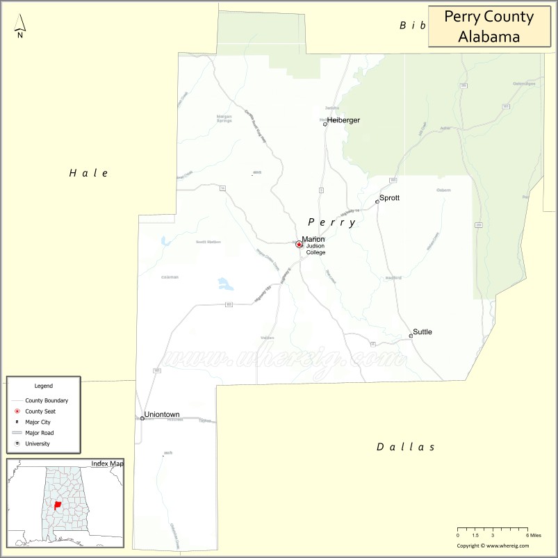
About Perry County Map, Alabama: The map showing the county boundary, county seat, major cities, highways, water bodies and neighbouring counties.
Most Viewed Links
Map of Perry County, Alabama
Perry County is a county located in the U.S. state of Alabama. It`s county seat is Marion. As per 2020 census, the population of Perry County was 8355 and population density of Perry was 11.6square miles. According to the United States Census Bureau, the county has a total area of 719.66 sq mi (1,864 km2). Perry County was established on 1819.
Perry County Facts
| Continent | North America |
| Country | United States |
| State | Alabama |
| County Seat | Marion |
| Largest City/Town | Marion |
| Established | December 13, 1819 |
| Total Area | 723 sq mi (1,873 sq km) |
| Land Area | 720 sq mi (1,865 sq km) |
| Water Area | 3 sq mi (8 sq km) |
| Population | 8,511 (Census 2020) |
| Population Density | 12 people per sq mi |
| Time Zone | Central Time Zone (CT) |
| Major Highways | US 80, AL 5, AL 14, AL 61, AL 183 |
| Major Rivers | Cahaba River, Oakmulgee Creek |
| Neighboring Counties | Hale County, Bibb County, Chilton County, Dallas County, Marengo County, Wilcox County |
| Famous For | Marion Military Institute, Judson College heritage, Civil Rights history, and Alabama Black Belt culture |
| Top Attractions | Marion Military Institute, Siloam Baptist Church, Perry Lakes Park, Cahaba River, and historic downtown Marion |
| Official Website | Official Website |
About Perry County, Alabama
Perry County is located in west-central Alabama within the Black Belt region and was established in 1819. The county seat and largest city is Marion. The county is known for its educational history, Civil Rights heritage, and rich agricultural traditions. Rolling countryside, river systems, and historic communities contribute to the county's distinctive character and historical significance.
Cities and Towns in Perry County, Alabama
| City/Town | Population (Census 2020) | Latitude & Longitude |
|---|---|---|
| Marion (county seat) | 2,970 | 32.6321°N, 87.3192°W |
| Uniontown | 1,775 | 32.4490°N, 87.5142°W |
| Newbern | 133 | 32.5932°N, 87.5336°W |
| Heiberger (CDP) | 421 | 32.7515°N, 87.2805°W |
| Sprott (CDP) | 205 | 32.6629°N, 87.1467°W |
| Hamburg (CDP) | 115 | 32.5254°N, 87.3749°W |
| Marion Junction (CDP) | 262 | 32.4425°N, 87.2358°W |
| Faunsdale Junction (CDP) | 84 | 32.4981°N, 87.4682°W |
Best Golf Courses in Perry County, Alabama
| Golf Course | Location | Latitude & Longitude |
|---|---|---|
| Marion Country Club | Marion | 32.6394°N, 87.3158°W |
| Perry Lakes Recreation Golf Area | Marion | 32.6617°N, 87.3431°W |
| Uniontown Community Golf Course | Uniontown | 32.4518°N, 87.5117°W |
What are Major Roads and Highways in Perry County
Major highways connect the county to nearby regions and cities.
- US Highway 80 - major east-west route connecting Uniontown and Marion with Selma and Demopolis
- Alabama State Route 5 - north-south highway linking Marion with Bibb County and Dallas County
- Alabama State Route 14 - crosses the county connecting Marion with Selma and Greensboro
- Alabama State Route 61 - serves western Perry County communities
- Alabama State Route 183 - connects Marion with Interstate 65 and central Alabama
Neighboring Counties of Perry County
- Bibb County (northeast)
- Chilton County (east)
- Dallas County (southeast)
- Wilcox County (south)
- Marengo County (west)
- Hale County (northwest)
What are Top Attractions in Perry County, Alabama
The county offers a mix of natural and cultural attractions.
| Main Sight Name | City | Famous For |
|---|---|---|
| Marion Military Institute | Marion | Historic military junior college founded in 1842 |
| Perry Lakes Park | Marion | Birdwatching, wetlands, and nature trails |
| Cahaba River National Wildlife Area | Countywide | Scenic river habitats and biodiversity |
| Siloam Baptist Church | Marion | Historic Civil Rights landmark |
| Historic Downtown Marion | Marion | Antebellum architecture and local history |
| Judson College Historic Campus | Marion | Important educational heritage site |
| Newbern Historic District | Newbern | Historic Black Belt architecture |
| Uniontown Historic Area | Uniontown | Historic churches and community landmarks |
| Oakmulgee Creek Area | Countywide | Fishing and outdoor recreation |
| Barton’s Beach Cahaba River Access | Marion Area | Popular river access and kayaking location |
| Perry County Courthouse | Marion | Historic county government building |
| Black Belt Prairie Landscapes | Countywide | Unique geological and agricultural scenery |
Distance from Perry County to Nearby Cities
The following distances are measured by road (driving).
- Marion to Uniontown (Perry County), Alabama - 15 mi (24 km)
- Marion to Newbern (Perry County), Alabama - 13 mi (21 km)
- Marion to Marion Junction (Perry County), Alabama - 16 mi (26 km)
- Marion to Greensboro (Hale County), Alabama - 21 mi (34 km)
- Marion to Selma (Dallas County), Alabama - 29 mi (47 km)
- Marion to Centreville (Bibb County), Alabama - 37 mi (60 km)
- Marion to Clanton (Chilton County), Alabama - 48 mi (77 km)
- Marion to Camden (Wilcox County), Alabama - 43 mi (69 km)
- Marion to Demopolis (Marengo County), Alabama - 41 mi (66 km)
- Marion to Tuscaloosa (Tuscaloosa County), Alabama - 62 mi (100 km)
- Marion to Montgomery (Montgomery County), Alabama - 74 mi (119 km)
- Marion to Birmingham (Jefferson County), Alabama - 78 mi (126 km)
- Marion to Auburn (Lee County), Alabama - 118 mi (190 km)
- Marion to Mobile (Mobile County), Alabama - 170 mi (274 km)
Nearest Airports
Nearest airport of Perry is Montgomery Regional Airport.
References
- QuickFacts - U.S. Census Bureau
- United States Census Bureau
- United States Geological Survey (USGS)
- National Geodetic Survey
- Official County Website
- Autauga County Map
- Baldwin County Map
- Barbour County Map
- Bibb County Map
- Blount County Map
- Bullock County Map
- Butler County Map
- Calhoun County Map
- Chambers County Map
- Cherokee County Map
- Chilton County Map
- Choctaw County Map
- Clarke County Map
- Clay County Map
- Cleburne County Map
- Coffee County Map
- Colbert County Map
- Conecuh County Map
- Coosa County Map
- Covington County Map
- Crenshaw County Map
- Cullman County Map
- Dale County Map
- Dallas County Map
- DeKalb County Map
- Elmore County Map
- Escambia County Map
- Etowah County Map
- Fayette County Map
- Franklin County Map
- Geneva County Map
- Greene County Map
- Hale County Map
- Henry County Map
- Houston County Map
- Jackson County Map
- Jefferson County Map
- Lamar County Map
- Lauderdale County Map
- Lawrence County Map
- Lee County Map
- Limestone County Map
- Lowndes County Map
- Macon County Map
- Madison County Map
- Marengo County Map
- Marion County Map
- Marshall County Map
- Mobile County Map
- Monroe County Map
- Montgomery County Map
- Morgan County Map
- Perry County Map
- Pickens County Map
- Pike County Map
- Randolph County Map
- Russell County Map
- St Clair County Map
- Shelby County Map
- Sumter County Map
- Talladega County Map
- Tallapoosa County Map
- Tuscaloosa County Map
- Walker County Map
- Washington County Map
- Wilcox County Map
- Winston County Map
- Alabama Counties
- Alaska boroughs
- Arizona Counties
- Arkansas Counties
- California County Map
- Colorado Counties
- Connecticut Counties
- Delaware Counties
- Florida County Map
- Georgia County Map
- Hawaii Counties
- Idaho Counties
- Illinois Counties
- Indiana Counties
- Iowa Counties
- Kansas Counties
- Kentucky Counties
- Louisiana Counties
- Maine Counties
- Maryland Counties
- Massachusetts Counties
- Michigan County Map
- Minnesota Counties
- Mississippi Counties
- Missouri Counties
- Montana Counties
- Nebraska Counties
- Nevada Counties
- New York Counties
- New Hampshire Counties
- New Jersey Counties
- New Mexico Counties
- North Carolina Counties
- North Dakota Counties
- Ohio County Map
- Oklahoma Counties
- Oregon Counties
- Pennsylvania Counties
- Rhode Island Counties
- South Carolina Counties
- South Dakota Counties
- Map of Tennessee
- Texas County Map
- Utah Counties
- Vermont Counties
- Virginia Counties
- Washington Counties
- West Virginia Counties
- Wisconsin Counties
- Wyoming Counties