Map of Clarke County - Clarke County is a county located in the U.S. state of Alabama. Clarke County Map showing cities, highways, important places and water bodies. Get Where is Clarke County located in the map, major cities in Clarke county, population, areas, and places of interest.
Clarke County Map, Alabama
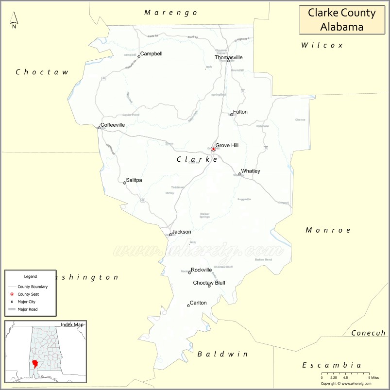
About Clarke County Map, Alabama: The map showing the county boundary, county seat, major cities, highways, water bodies and neighbouring counties.
Most Viewed Links
Map of Clarke County, Alabama
Clarke County is a county located in the U.S. state of Alabama. It`s county seat is Grove Hill. As per 2020 census, the population of Clarke County was 22760 and population density of Clarke was 18.4square miles. According to the United States Census Bureau, the county has a total area of 1,238.46 sq mi (3,208 km2). Clarke County was established on 1812.
Clarke County Facts
| Continent | North America |
| Country | United States |
| State | Alabama |
| County Seat | Grove Hill |
| Largest City/Town | Jackson |
| Established | December 10, 1812 |
| Total Area | 1,253 sq mi (3,245 sq km) |
| Land Area | 1,238 sq mi (3,207 sq km) |
| Water Area | 15 sq mi (39 sq km) |
| Population | 23,087 (Census 2020) |
| Population Density | 19 people per sq mi |
| Time Zone | Central Time Zone (CT) |
| Major Highways | US 43, US 84, AL 5, AL 69, AL 178 |
| Major Rivers | Tombigbee River, Alabama River, Satilpa Creek |
| Neighboring Counties | Marengo County, Wilcox County, Monroe County, Washington County, Choctaw County, Baldwin County |
| Famous For | Tombigbee River, timber industry, historic communities, and outdoor recreation |
| Top Attractions | Clarke County Museum, Choctaw Corner, Tombigbee River, Walker Springs Park, Jackson Historic District |
| Official Website | Official Website |
About Clarke County, Alabama
Clarke County is located in southwestern Alabama and was established in 1812, making it one of the oldest counties in the state. The county seat is Grove Hill, while Jackson is the largest city. The county is characterized by extensive forests, major river systems, and a strong timber and manufacturing economy, with the Tombigbee River serving as an important transportation and recreation corridor.
Cities and Towns in Clarke County, Alabama
| City/Town | Population (Census 2020) | Latitude & Longitude |
|---|---|---|
| Grove Hill (county seat) | 1,570 | 31.7082°N, 87.7775°W |
| Jackson | 4,771 | 31.5096°N, 87.8947°W |
| Thomasville | 3,950 | 31.9132°N, 87.7358°W |
| Coffeeville | 391 | 31.7571°N, 88.0897°W |
| Fulton | 215 | 31.7924°N, 87.7304°W |
| Carlton (CDP) | 65 | 31.6525°N, 87.9717°W |
| Campbell (CDP) | 176 | 31.9240°N, 88.0097°W |
| Whatley (CDP) | 141 | 31.6508°N, 87.7125°W |
| Walker Springs (CDP) | 186 | 31.6390°N, 87.7988°W |
Best Golf Courses in Clarke County, Alabama
| Golf Course | Location | Latitude & Longitude |
|---|---|---|
| Jackson Links Golf Course | Jackson | 31.5208°N, 87.8735°W |
| Thomasville Country Club | Thomasville | 31.9158°N, 87.7366°W |
| Grove Hill Municipal Golf Course | Grove Hill | 31.7075°N, 87.7894°W |
What are Major Roads and Highways in Clarke County
Major highways connect the county to nearby regions and cities.
- US Highway 43 - major north-south route connecting Thomasville, Jackson, and Mobile
- US Highway 84 - east-west route connecting Grove Hill with Waynesboro, Mississippi and Evergreen
- Alabama State Route 5 - connects Thomasville with Marion and central Alabama
- Alabama State Route 69 - serves western Clarke County communities
- Alabama State Route 178 - links Jackson with local communities and industrial areas
Neighboring Counties of Clarke County
- Marengo County (north)
- Wilcox County (northeast)
- Monroe County (east)
- Baldwin County (southeast)
- Washington County (southwest)
- Choctaw County (west)
What are Top Attractions in Clarke County, Alabama
The county offers a mix of natural and cultural attractions.
| Main Sight Name | City | Famous For |
|---|---|---|
| Clarke County Museum | Grove Hill | Local history exhibits and historic buildings |
| Choctaw Corner | Thomasville | Historic Native American and pioneer settlement site |
| Tombigbee River | Countywide | Boating, fishing, and river scenery |
| Jackson Historic District | Jackson | Historic architecture and downtown heritage |
| Walker Springs Park | Walker Springs | Outdoor recreation and community events |
| Thomasville Civic Center Area | Thomasville | Community gatherings and local events |
| Old St. Stephens Historical Park | Near Coffeeville | Historic territorial capital site |
| Coffeeville Lock and Dam | Coffeeville | River navigation and fishing opportunities |
| Satilpa Creek Wildlife Areas | Countywide | Nature viewing and outdoor activities |
| Grove Hill Courthouse Square | Grove Hill | Historic county landmark |
| Jackson Riverfront Areas | Jackson | Scenic outdoor recreation |
| Thomasville Rose Trail | Thomasville | Gardens and seasonal floral displays |
Distance from Clarke County to Nearby Cities
The following distances are measured by road (driving).
- Grove Hill to Jackson (Clarke County), Alabama - 15 mi (24 km)
- Grove Hill to Thomasville (Clarke County), Alabama - 18 mi (29 km)
- Grove Hill to Coffeeville (Clarke County), Alabama - 21 mi (34 km)
- Grove Hill to Monroeville (Monroe County), Alabama - 38 mi (61 km)
- Grove Hill to Evergreen (Conecuh County), Alabama - 48 mi (77 km)
- Grove Hill to Demopolis (Marengo County), Alabama - 53 mi (85 km)
- Grove Hill to Butler (Choctaw County), Alabama - 39 mi (63 km)
- Grove Hill to Atmore (Escambia County), Alabama - 61 mi (98 km)
- Grove Hill to Mobile (Mobile County), Alabama - 82 mi (132 km)
- Grove Hill to Selma (Dallas County), Alabama - 96 mi (154 km)
- Grove Hill to Montgomery (Montgomery County), Alabama - 117 mi (188 km)
- Grove Hill to Meridian, Mississippi - 95 mi (153 km)
- Grove Hill to Birmingham (Jefferson County), Alabama - 168 mi (270 km)
Nearest Airports
Nearest airport of Clarke is Jackson Municipal Airport-4R3.
References
- QuickFacts - U.S. Census Bureau
- United States Census Bureau
- United States Geological Survey (USGS)
- National Geodetic Survey
- Official County Website
- Autauga County Map
- Baldwin County Map
- Barbour County Map
- Bibb County Map
- Blount County Map
- Bullock County Map
- Butler County Map
- Calhoun County Map
- Chambers County Map
- Cherokee County Map
- Chilton County Map
- Choctaw County Map
- Clarke County Map
- Clay County Map
- Cleburne County Map
- Coffee County Map
- Colbert County Map
- Conecuh County Map
- Coosa County Map
- Covington County Map
- Crenshaw County Map
- Cullman County Map
- Dale County Map
- Dallas County Map
- DeKalb County Map
- Elmore County Map
- Escambia County Map
- Etowah County Map
- Fayette County Map
- Franklin County Map
- Geneva County Map
- Greene County Map
- Hale County Map
- Henry County Map
- Houston County Map
- Jackson County Map
- Jefferson County Map
- Lamar County Map
- Lauderdale County Map
- Lawrence County Map
- Lee County Map
- Limestone County Map
- Lowndes County Map
- Macon County Map
- Madison County Map
- Marengo County Map
- Marion County Map
- Marshall County Map
- Mobile County Map
- Monroe County Map
- Montgomery County Map
- Morgan County Map
- Perry County Map
- Pickens County Map
- Pike County Map
- Randolph County Map
- Russell County Map
- St Clair County Map
- Shelby County Map
- Sumter County Map
- Talladega County Map
- Tallapoosa County Map
- Tuscaloosa County Map
- Walker County Map
- Washington County Map
- Wilcox County Map
- Winston County Map
- Alabama Counties
- Alaska boroughs
- Arizona Counties
- Arkansas Counties
- California County Map
- Colorado Counties
- Connecticut Counties
- Delaware Counties
- Florida County Map
- Georgia County Map
- Hawaii Counties
- Idaho Counties
- Illinois Counties
- Indiana Counties
- Iowa Counties
- Kansas Counties
- Kentucky Counties
- Louisiana Counties
- Maine Counties
- Maryland Counties
- Massachusetts Counties
- Michigan County Map
- Minnesota Counties
- Mississippi Counties
- Missouri Counties
- Montana Counties
- Nebraska Counties
- Nevada Counties
- New York Counties
- New Hampshire Counties
- New Jersey Counties
- New Mexico Counties
- North Carolina Counties
- North Dakota Counties
- Ohio County Map
- Oklahoma Counties
- Oregon Counties
- Pennsylvania Counties
- Rhode Island Counties
- South Carolina Counties
- South Dakota Counties
- Map of Tennessee
- Texas County Map
- Utah Counties
- Vermont Counties
- Virginia Counties
- Washington Counties
- West Virginia Counties
- Wisconsin Counties
- Wyoming Counties