Map of St. Clair County - St. Clair County is a county located in the U.S. state of Alabama. St. Clair County Map showing cities, highways, important places and water bodies. Get Where is St. Clair County located in the map, major cities in St. Clair county, population, areas, and places of interest.
St Clair County Map, Alabama
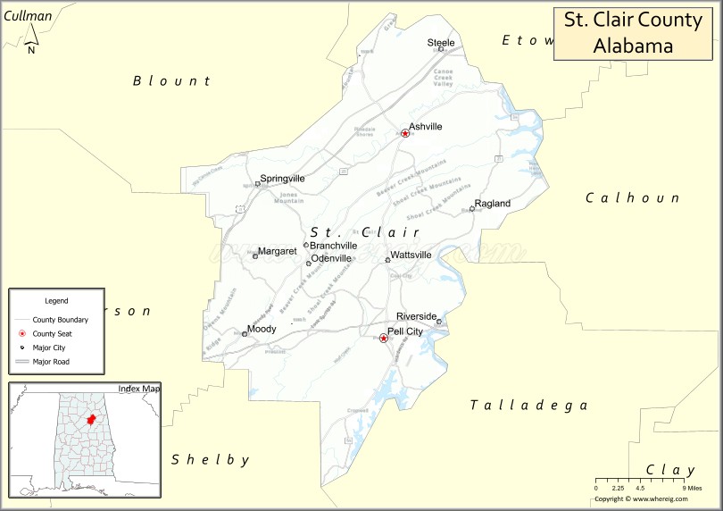
About St. Clair County Map, Alabama: The map showing the county boundary, county seat, major cities, highways, water bodies and neighbouring counties.
Most Viewed Links
Map of St Clair County, Alabama
St. Clair County is a county located in the U.S. state of Alabama. It`s county seat is Ashville and Pell City. As per 2020 census, the population of St. Clair County was 92748 and population density of St. Clair was 146.8square miles. According to the United States Census Bureau, the county has a total area of 631.90 sq mi (1,637 km2). St. Clair County was established on 1818.
St. Clair County Facts
| Continent | North America |
| Country | United States |
| State | Alabama |
| County Seat | Ashville and Pell City |
| Largest City/Town | Pell City |
| Established | November 20, 1818 |
| Total Area | 654 sq mi (1,694 sq km) |
| Land Area | 632 sq mi (1,637 sq km) |
| Water Area | 22 sq mi (57 sq km) |
| Population | 91,103 (Census 2020) |
| Population Density | 144 people per sq mi |
| Time Zone | Central Time Zone (CT) |
| Major Highways | Interstate 20, US 231, US 411, AL 23, AL 34, AL 174 |
| Major Rivers | Coosa River |
| Neighboring Counties | Etowah County, Calhoun County, Talladega County, Shelby County, Jefferson County, Blount County |
| Famous For | Logan Martin Lake, Coosa River recreation, scenic mountains, and rapid residential growth |
| Top Attractions | Logan Martin Lake, Horse Pens 40, Majestic Caverns, Pell City Lakeside Park, and Coosa River recreation |
| Official Website | Official Website |
About St. Clair County, Alabama
St. Clair County is located in east-central Alabama and was established in 1818. The county has two county seats, Ashville and Pell City, with Pell City being the largest municipality. The county lies along the Coosa River and includes much of Logan Martin Lake, making it a popular destination for boating, fishing, and outdoor recreation. Its proximity to Birmingham has contributed to steady population growth and economic development.
Cities and Towns in St. Clair County, Alabama
| City/Town | Population (Census 2020) | Latitude & Longitude |
|---|---|---|
| Ashville (county seat) | 2,212 | 33.8370°N, 86.2547°W |
| Pell City (county seat) | 13,270 | 33.5862°N, 86.2861°W |
| Argo (partly in St. Clair County) | 4,236 | 33.6923°N, 86.5005°W |
| Margaret (partly in St. Clair County) | 5,149 | 33.6804°N, 86.4744°W |
| Moody (partly in St. Clair County) | 13,170 | 33.5909°N, 86.4994°W |
| Odenville | 5,004 | 33.6823°N, 86.3961°W |
| Ragland | 1,639 | 33.7440°N, 86.1558°W |
| Riverside | 2,564 | 33.6076°N, 86.2043°W |
| Springville (partly in St. Clair County) | 4,786 | 33.7751°N, 86.4714°W |
| Steele | 1,043 | 33.9398°N, 86.2013°W |
| Branchville | 2,650 | 33.6531°N, 86.4377°W |
| Cook Springs (CDP) | 1,217 | 33.5936°N, 86.3174°W |
| Eden (CDP) | 1,035 | 33.6912°N, 86.3581°W |
| Shoal Creek (CDP) | 1,274 | 33.5674°N, 86.3878°W |
Best Golf Courses in St. Clair County, Alabama
| Golf Course | Location | Latitude & Longitude |
|---|---|---|
| Pell City Country Club | Pell City | 33.6025°N, 86.2849°W |
| Cider Ridge Golf Club | Oxford Area | 33.6432°N, 85.9618°W |
| Coosa Pines Golf Club | Pell City | 33.5725°N, 86.2526°W |
| Trussville Country Club East Extension | Odenville Area | 33.6854°N, 86.3928°W |
| Whispering Pines Golf Course | Ragland | 33.7449°N, 86.1631°W |
What are Major Roads and Highways in St. Clair County
Major highways connect the county to nearby regions and cities.
- Interstate 20 - major east-west interstate connecting Birmingham and Atlanta through St. Clair County
- US Highway 231 - north-south route linking Pell City with Ashville and Montgomery
- US Highway 411 - connects Odenville, Ashville, and Gadsden
- Alabama State Route 23 - serves eastern portions of the county
- Alabama State Route 34 - connects Pell City with surrounding communities
- Alabama State Route 174 - provides access to Odenville and Springville areas
Neighboring Counties of St. Clair County
- Blount County (northwest)
- Etowah County (north)
- Calhoun County (east)
- Talladega County (south)
- Shelby County (southwest)
- Jefferson County (west)
What are Top Attractions in St. Clair County, Alabama
The county offers a mix of natural and cultural attractions.
| Main Sight Name | City | Famous For |
|---|---|---|
| Logan Martin Lake | Pell City | Boating, fishing, and lakeside recreation |
| Horse Pens 40 | Steele | World-famous bouldering and rock climbing destination |
| Majestic Caverns | Margaret Area | Historic cave tours and family attractions |
| Pell City Lakeside Park | Pell City | Swimming beach, trails, and waterfront views |
| Coosa River | Countywide | Fishing, kayaking, and scenic landscapes |
| Ashville Historic District | Ashville | Historic courthouse and downtown architecture |
| Big Canoe Creek Nature Preserve | Springville Area | Wildlife habitats and hiking opportunities |
| St. Clair County Museum | Ashville | Local history exhibits and artifacts |
| Moody City Park | Moody | Sports facilities and recreation |
| Riverside Landing | Riverside | Boat launches and river access |
| Branchville Heritage Area | Branchville | Small-town history and local culture |
| Ragland Depot Area | Ragland | Historic railroad heritage |
| Cook Springs Community Park | Cook Springs | Outdoor recreation and local events |
| Odenville Veterans Park | Odenville | Community gatherings and sports activities |
Distance from St. Clair County to Nearby Cities
The following distances are measured by road (driving).
- Pell City to Ashville (St. Clair County), Alabama - 19 mi (31 km)
- Pell City to Odenville (St. Clair County), Alabama - 16 mi (26 km)
- Pell City to Moody (St. Clair County), Alabama - 13 mi (21 km)
- Pell City to Riverside (St. Clair County), Alabama - 8 mi (13 km)
- Pell City to Springville (St. Clair County), Alabama - 16 mi (26 km)
- Pell City to Talladega (Talladega County), Alabama - 24 mi (39 km)
- Pell City to Gadsden (Etowah County), Alabama - 32 mi (51 km)
- Pell City to Birmingham (Jefferson County), Alabama - 35 mi (56 km)
- Pell City to Columbiana (Shelby County), Alabama - 37 mi (60 km)
- Pell City to Oneonta (Blount County), Alabama - 33 mi (53 km)
- Pell City to Anniston (Calhoun County), Alabama - 24 mi (39 km)
- Pell City to Clanton (Chilton County), Alabama - 53 mi (85 km)
- Pell City to Montgomery (Montgomery County), Alabama - 95 mi (153 km)
- Pell City to Huntsville (Madison County), Alabama - 104 mi (167 km)
- Pell City to Atlanta, Georgia - 133 mi (214 km)
Nearest Airports
Nearest airport of Clair is Sarnia Chris Hadfield Airport.
References
- QuickFacts - U.S. Census Bureau
- United States Census Bureau
- United States Geological Survey (USGS)
- National Geodetic Survey
- Official County Website
- Autauga County Map
- Baldwin County Map
- Barbour County Map
- Bibb County Map
- Blount County Map
- Bullock County Map
- Butler County Map
- Calhoun County Map
- Chambers County Map
- Cherokee County Map
- Chilton County Map
- Choctaw County Map
- Clarke County Map
- Clay County Map
- Cleburne County Map
- Coffee County Map
- Colbert County Map
- Conecuh County Map
- Coosa County Map
- Covington County Map
- Crenshaw County Map
- Cullman County Map
- Dale County Map
- Dallas County Map
- DeKalb County Map
- Elmore County Map
- Escambia County Map
- Etowah County Map
- Fayette County Map
- Franklin County Map
- Geneva County Map
- Greene County Map
- Hale County Map
- Henry County Map
- Houston County Map
- Jackson County Map
- Jefferson County Map
- Lamar County Map
- Lauderdale County Map
- Lawrence County Map
- Lee County Map
- Limestone County Map
- Lowndes County Map
- Macon County Map
- Madison County Map
- Marengo County Map
- Marion County Map
- Marshall County Map
- Mobile County Map
- Monroe County Map
- Montgomery County Map
- Morgan County Map
- Perry County Map
- Pickens County Map
- Pike County Map
- Randolph County Map
- Russell County Map
- St Clair County Map
- Shelby County Map
- Sumter County Map
- Talladega County Map
- Tallapoosa County Map
- Tuscaloosa County Map
- Walker County Map
- Washington County Map
- Wilcox County Map
- Winston County Map
- Alabama Counties
- Alaska boroughs
- Arizona Counties
- Arkansas Counties
- California County Map
- Colorado Counties
- Connecticut Counties
- Delaware Counties
- Florida County Map
- Georgia County Map
- Hawaii Counties
- Idaho Counties
- Illinois Counties
- Indiana Counties
- Iowa Counties
- Kansas Counties
- Kentucky Counties
- Louisiana Counties
- Maine Counties
- Maryland Counties
- Massachusetts Counties
- Michigan County Map
- Minnesota Counties
- Mississippi Counties
- Missouri Counties
- Montana Counties
- Nebraska Counties
- Nevada Counties
- New York Counties
- New Hampshire Counties
- New Jersey Counties
- New Mexico Counties
- North Carolina Counties
- North Dakota Counties
- Ohio County Map
- Oklahoma Counties
- Oregon Counties
- Pennsylvania Counties
- Rhode Island Counties
- South Carolina Counties
- South Dakota Counties
- Map of Tennessee
- Texas County Map
- Utah Counties
- Vermont Counties
- Virginia Counties
- Washington Counties
- West Virginia Counties
- Wisconsin Counties
- Wyoming Counties