Map of Lowndes County - Lowndes County is a county located in the U.S. state of Lowndes. Lowndes County Map showing cities, highways, important places and water bodies. Get Where is Lowndes County located in the map, major cities in Lowndes county, population, areas, and places of interest.
Lowndes County Map, Lowndes
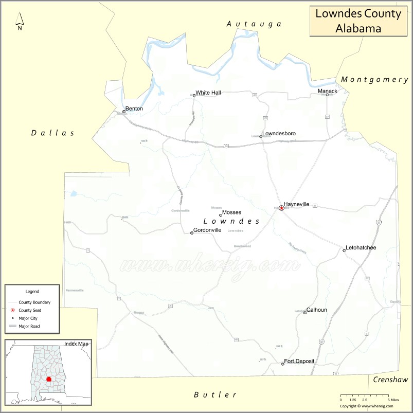
About Lowndes County Map, Lowndes: The map showing the county boundary, county seat, major cities, highways, water bodies and neighbouring counties.
Most Viewed Links
Map of Lowndes County, Lowndes
Lowndes County is a county located in the U.S. state of Lowndes. It`s county seat is Hayneville. As per 2020 census, the population of Lowndes County was 9965 and population density of Lowndes was 13.9square miles. According to the United States Census Bureau, the county has a total area of 715.91 sq mi (1,854 km2). Lowndes County was established on 1830.
Lowndes County Facts
| Continent | North America |
| Country | United States |
| State | Alabama |
| County Seat | Hayneville |
| Largest City/Town | Fort Deposit |
| Established | January 20, 1830 |
| Total Area | 725 sq mi (1,878 sq km) |
| Land Area | 716 sq mi (1,854 sq km) |
| Water Area | 9 sq mi (23 sq km) |
| Population | 9,746 (Census 2020) |
| Population Density | 14 people per sq mi |
| Time Zone | Central Time Zone (CT) |
| Major Highways | Interstate 65, US 31, AL 21, AL 97 |
| Major Rivers | Alabama River, Big Swamp Creek, Pintlala Creek |
| Neighboring Counties | Dallas County, Montgomery County, Butler County, Crenshaw County, Wilcox County |
| Famous For | Civil Rights history, the Alabama Black Belt, rural heritage, and the Freedom Trail |
| Top Attractions | Lowndes Interpretive Center, Freedom Trail sites, Fort Deposit Historic District, and Alabama River recreation |
| Official Website | Official Website |
About Lowndes County, Alabama
Lowndes County is located in south-central Alabama within the historic Black Belt region and was established in 1830. The county seat is Hayneville, while Fort Deposit is the largest municipality. The county played a significant role during the Civil Rights Movement and remains an important part of Alabama's cultural and historical landscape. Rolling farmland, forests, and river systems characterize much of the county's geography.
Cities and Towns in Lowndes County, Alabama
| City/Town | Population (Census 2020) | Latitude & Longitude |
|---|---|---|
| Hayneville (county seat) | 932 | 32.1857°N, 86.5805°W |
| Fort Deposit | 1,184 | 31.9846°N, 86.5786°W |
| White Hall | 631 | 32.3084°N, 86.7116°W |
| Mosses | 978 | 32.1745°N, 86.6727°W |
| Lowndesboro | 115 | 32.2702°N, 86.6105°W |
| Gordonville (CDP) | 326 | 32.0928°N, 86.7203°W |
| Benton (CDP) | 41 | 32.3048°N, 86.7847°W |
| Calhoun (CDP) | 435 | 32.4447°N, 86.7087°W |
| Burkville (CDP) | 186 | 32.6225°N, 86.5641°W |
Best Golf Courses in Lowndes County, Alabama
| Golf Course | Location | Latitude & Longitude |
|---|---|---|
| Lowndes County Golf Club | Fort Deposit | 31.9874°N, 86.5869°W |
| Fort Deposit Country Club | Fort Deposit | 31.9926°N, 86.5718°W |
What are Major Roads and Highways in Lowndes County
Major highways connect the county to nearby regions and cities.
- Interstate 65 - major north-south interstate connecting Montgomery with Mobile through the county
- US Highway 31 - historic route paralleling Interstate 65 through Fort Deposit and Hayneville
- Alabama State Route 21 - connects Hayneville with Montgomery and southern Alabama communities
- Alabama State Route 97 - serves local communities and provides access to western portions of the county
Neighboring Counties of Lowndes County
- Montgomery County (north)
- Dallas County (west)
- Wilcox County (southwest)
- Butler County (south)
- Crenshaw County (southeast)
What are Top Attractions in Lowndes County, Alabama
The county offers a mix of natural and cultural attractions.
| Main Sight Name | City | Famous For |
|---|---|---|
| Lowndes Interpretive Center | Hayneville | Civil Rights Movement exhibits and education |
| Lowndes County Freedom Trail Sites | Countywide | Historic Civil Rights landmarks |
| Fort Deposit Historic District | Fort Deposit | Historic architecture and local heritage |
| White Hall Historic Area | White Hall | Black Belt history and community landmarks |
| Alabama River | Western County | Fishing, boating, and wildlife viewing |
| Lowndesboro Historic District | Lowndesboro | Antebellum homes and historic churches |
| Mosses Cultural Center | Mosses | Local heritage and community events |
| Calhoun School Museum Area | Calhoun | African American educational history |
| Fort Deposit Railroad Heritage Site | Fort Deposit | Historic railroad connections |
| Pintlala Creek Recreation Area | Northern County | Nature viewing and outdoor recreation |
Distance from Lowndes County to Nearby Cities
The following distances are measured by road (driving).
- Hayneville to Fort Deposit (Lowndes County), Alabama - 15 mi (24 km)
- Hayneville to White Hall (Lowndes County), Alabama - 12 mi (19 km)
- Hayneville to Mosses (Lowndes County), Alabama - 7 mi (11 km)
- Hayneville to Lowndesboro (Lowndes County), Alabama - 6 mi (10 km)
- Hayneville to Montgomery (Montgomery County), Alabama - 24 mi (39 km)
- Hayneville to Selma (Dallas County), Alabama - 38 mi (61 km)
- Hayneville to Greenville (Butler County), Alabama - 34 mi (55 km)
- Hayneville to Luverne (Crenshaw County), Alabama - 42 mi (68 km)
- Hayneville to Camden (Wilcox County), Alabama - 47 mi (76 km)
- Hayneville to Prattville (Autauga County), Alabama - 33 mi (53 km)
- Hayneville to Troy (Pike County), Alabama - 63 mi (101 km)
- Hayneville to Auburn (Lee County), Alabama - 77 mi (124 km)
- Hayneville to Birmingham (Jefferson County), Alabama - 105 mi (169 km)
- Hayneville to Mobile (Mobile County), Alabama - 145 mi (233 km)
Nearest Airports
Nearest airport of Lowndes is Valdosta Regional Airport (VLD / KVLD).
References
- QuickFacts - U.S. Census Bureau
- United States Census Bureau
- United States Geological Survey (USGS)
- National Geodetic Survey
- Official County Website
- Alabama Counties
- Alaska boroughs
- Arizona Counties
- Arkansas Counties
- California County Map
- Colorado Counties
- Connecticut Counties
- Delaware Counties
- Florida County Map
- Georgia County Map
- Hawaii Counties
- Idaho Counties
- Illinois Counties
- Indiana Counties
- Iowa Counties
- Kansas Counties
- Kentucky Counties
- Louisiana Counties
- Maine Counties
- Maryland Counties
- Massachusetts Counties
- Michigan County Map
- Minnesota Counties
- Mississippi Counties
- Missouri Counties
- Montana Counties
- Nebraska Counties
- Nevada Counties
- New York Counties
- New Hampshire Counties
- New Jersey Counties
- New Mexico Counties
- North Carolina Counties
- North Dakota Counties
- Ohio County Map
- Oklahoma Counties
- Oregon Counties
- Pennsylvania Counties
- Rhode Island Counties
- South Carolina Counties
- South Dakota Counties
- Map of Tennessee
- Texas County Map
- Utah Counties
- Vermont Counties
- Virginia Counties
- Washington Counties
- West Virginia Counties
- Wisconsin Counties
- Wyoming Counties