Map of Russell County - Russell County is a county located in the U.S. state of Alabama. Russell County Map showing cities, highways, important places and water bodies. Get Where is Russell County located in the map, major cities in Russell county, population, areas, and places of interest.
Russell County Map, Alabama
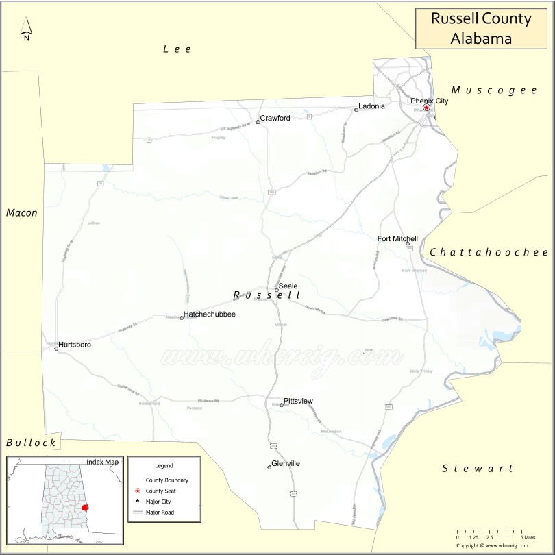
About Russell County Map, Alabama: The map showing the county boundary, county seat, major cities, highways, water bodies and neighbouring counties.
Most Viewed Links
Map of Russell County, Alabama
Russell County is a county located in the U.S. state of Alabama. It`s county seat is Phenix City. As per 2020 census, the population of Russell County was 58722 and population density of Russell was 91.6square miles. According to the United States Census Bureau, the county has a total area of 641.14 sq mi (1,661 km2). Russell County was established on 1832.
Russell County Facts
| Continent | North America |
| Country | United States |
| State | Alabama |
| County Seat | Phenix City |
| Largest City/Town | Phenix City |
| Established | December 18, 1832 |
| Total Area | 647 sq mi (1,676 sq km) |
| Land Area | 641 sq mi (1,660 sq km) |
| Water Area | 6 sq mi (16 sq km) |
| Population | 59,183 (Census 2020) |
| Population Density | 92 people per sq mi |
| Time Zone | Central Time Zone (CT) |
| Major Highways | US 80, US 280, US 431, AL 165, AL 169 |
| Major Rivers | Chattahoochee River |
| Neighboring Counties | Lee County, Macon County, Bullock County, Barbour County, Muscogee County (GA), Chattahoochee County (GA) |
| Famous For | Phenix City, Chattahoochee River recreation, military connections to Fort Benning, and whitewater rafting |
| Top Attractions | Whitewater Express, Phenix City Riverwalk, Idle Hour Park, Chattahoochee River, and the National Infantry Museum nearby |
| Official Website | Official Website |
About Russell County, Alabama
Russell County is located in eastern Alabama along the Georgia border and was established in 1832. The county seat and largest city is Phenix City. The Chattahoochee River forms the county's eastern boundary and has played an important role in its history and economy. Russell County is known for outdoor recreation, military-related activity connected to nearby Fort Benning, and its growing role within the Columbus metropolitan area.
Cities and Towns in Russell County, Alabama
| City/Town | Population (Census 2020) | Latitude & Longitude |
|---|---|---|
| Phenix City (county seat) | 38,817 | 32.4709°N, 85.0008°W |
| Hurtsboro | 349 | 32.2418°N, 85.4163°W |
| Ladonia (CDP) | 3,142 | 32.4762°N, 85.0481°W |
| Seale (CDP) | 2,158 | 32.3064°N, 85.1735°W |
| Crawford (CDP) | 556 | 32.5478°N, 85.1846°W |
| Hatchechubbee (CDP) | 488 | 32.2907°N, 85.3035°W |
| Uchee (CDP) | 379 | 32.3835°N, 85.0975°W |
| Fort Mitchell (CDP) | 3,625 | 32.3427°N, 85.0210°W |
| Cottonton (CDP) | 119 | 32.1412°N, 85.1390°W |
| Pittsview (CDP) | 514 | 32.1743°N, 85.1657°W |
Best Golf Courses in Russell County, Alabama
| Golf Course | Location | Latitude & Longitude |
|---|---|---|
| Lakewood Golf Course | Phenix City | 32.4854°N, 84.9788°W |
| Meadow Links Golf Course | Fort Mitchell | 32.3405°N, 85.0162°W |
| Fort Moore Golf Club | Fort Mitchell Area | 32.3579°N, 84.9557°W |
| Phenix City Country Club | Phenix City | 32.4692°N, 84.9971°W |
What are Major Roads and Highways in Russell County
Major highways connect the county to nearby regions and cities.
- US Highway 80 - major east-west route connecting Phenix City with Montgomery and Columbus, Georgia
- US Highway 280 - regional corridor linking Phenix City with Auburn and Birmingham
- US Highway 431 - north-south highway connecting Russell County with Eufaula and Opelika
- Alabama State Route 165 - serves Fort Mitchell and southern portions of the county
- Alabama State Route 169 - connects Phenix City with Crawford and Lee County
Neighboring Counties of Russell County
- Lee County (north)
- Macon County (northwest)
- Bullock County (west)
- Barbour County (south)
- Muscogee County, Georgia (east)
- Chattahoochee County, Georgia (southeast)
What are Top Attractions in Russell County, Alabama
The county offers a mix of natural and cultural attractions.
| Main Sight Name | City | Famous For |
|---|---|---|
| Whitewater Express | Phenix City | World-class whitewater rafting on the Chattahoochee River |
| Phenix City Riverwalk | Phenix City | Scenic walking trails along the riverfront |
| Idle Hour Park | Phenix City | Sports facilities and family recreation |
| Chattahoochee River | Countywide | Boating, fishing, kayaking, and rafting |
| Fort Mitchell Historic Site | Fort Mitchell | Historic military fort and museum |
| Russell County Sports Complex | Seale | Community sporting events and recreation |
| Moon Lake Recreation Area | Phenix City | Fishing and outdoor activities |
| Crawford Heritage Area | Crawford | Historic rural Alabama landscapes |
| Hurtsboro Historic District | Hurtsboro | Historic railroad-era architecture |
| Fort Mitchell National Cemetery | Fort Mitchell | Military memorial and historic significance |
| Phenix City Amphitheater | Phenix City | Concerts and community events |
| Uchee Creek Area | Uchee | Nature viewing and outdoor recreation |
Distance from Russell County to Nearby Cities
The following distances are measured by road (driving).
- Phenix City to Fort Mitchell (Russell County), Alabama - 12 mi (19 km)
- Phenix City to Seale (Russell County), Alabama - 15 mi (24 km)
- Phenix City to Crawford (Russell County), Alabama - 13 mi (21 km)
- Phenix City to Hurtsboro (Russell County), Alabama - 27 mi (43 km)
- Phenix City to Opelika (Lee County), Alabama - 28 mi (45 km)
- Phenix City to Auburn (Lee County), Alabama - 32 mi (51 km)
- Phenix City to Tuskegee (Macon County), Alabama - 34 mi (55 km)
- Phenix City to Union Springs (Bullock County), Alabama - 41 mi (66 km)
- Phenix City to Eufaula (Barbour County), Alabama - 48 mi (77 km)
- Phenix City to Columbus, Georgia - 3 mi (5 km)
- Phenix City to LaGrange, Georgia - 48 mi (77 km)
- Phenix City to Montgomery (Montgomery County), Alabama - 84 mi (135 km)
- Phenix City to Birmingham (Jefferson County), Alabama - 112 mi (180 km)
- Phenix City to Atlanta, Georgia - 108 mi (174 km)
Nearest Airports
Nearest airport of Russell is Columbus Metropolitan Airport (CSG / KCSG).
References
- QuickFacts - U.S. Census Bureau
- United States Census Bureau
- United States Geological Survey (USGS)
- National Geodetic Survey
- Official County Website
- Autauga County Map
- Baldwin County Map
- Barbour County Map
- Bibb County Map
- Blount County Map
- Bullock County Map
- Butler County Map
- Calhoun County Map
- Chambers County Map
- Cherokee County Map
- Chilton County Map
- Choctaw County Map
- Clarke County Map
- Clay County Map
- Cleburne County Map
- Coffee County Map
- Colbert County Map
- Conecuh County Map
- Coosa County Map
- Covington County Map
- Crenshaw County Map
- Cullman County Map
- Dale County Map
- Dallas County Map
- DeKalb County Map
- Elmore County Map
- Escambia County Map
- Etowah County Map
- Fayette County Map
- Franklin County Map
- Geneva County Map
- Greene County Map
- Hale County Map
- Henry County Map
- Houston County Map
- Jackson County Map
- Jefferson County Map
- Lamar County Map
- Lauderdale County Map
- Lawrence County Map
- Lee County Map
- Limestone County Map
- Lowndes County Map
- Macon County Map
- Madison County Map
- Marengo County Map
- Marion County Map
- Marshall County Map
- Mobile County Map
- Monroe County Map
- Montgomery County Map
- Morgan County Map
- Perry County Map
- Pickens County Map
- Pike County Map
- Randolph County Map
- Russell County Map
- St Clair County Map
- Shelby County Map
- Sumter County Map
- Talladega County Map
- Tallapoosa County Map
- Tuscaloosa County Map
- Walker County Map
- Washington County Map
- Wilcox County Map
- Winston County Map
- Alabama Counties
- Alaska boroughs
- Arizona Counties
- Arkansas Counties
- California County Map
- Colorado Counties
- Connecticut Counties
- Delaware Counties
- Florida County Map
- Georgia County Map
- Hawaii Counties
- Idaho Counties
- Illinois Counties
- Indiana Counties
- Iowa Counties
- Kansas Counties
- Kentucky Counties
- Louisiana Counties
- Maine Counties
- Maryland Counties
- Massachusetts Counties
- Michigan County Map
- Minnesota Counties
- Mississippi Counties
- Missouri Counties
- Montana Counties
- Nebraska Counties
- Nevada Counties
- New York Counties
- New Hampshire Counties
- New Jersey Counties
- New Mexico Counties
- North Carolina Counties
- North Dakota Counties
- Ohio County Map
- Oklahoma Counties
- Oregon Counties
- Pennsylvania Counties
- Rhode Island Counties
- South Carolina Counties
- South Dakota Counties
- Map of Tennessee
- Texas County Map
- Utah Counties
- Vermont Counties
- Virginia Counties
- Washington Counties
- West Virginia Counties
- Wisconsin Counties
- Wyoming Counties