Map of Henry County - Henry County is a county located in the U.S. state of Alabama. Henry County Map showing cities, highways, important places and water bodies. Get Where is Henry County located in the map, major cities in Henry county, population, areas, and places of interest.
Henry County Map, Alabama
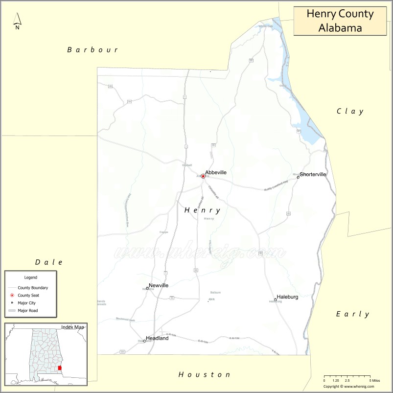
About Henry County Map, Alabama: The map showing the county boundary, county seat, major cities, highways, water bodies and neighbouring counties.
Most Viewed Links
Map of Henry County, Alabama
Henry County is a county located in the U.S. state of Alabama. It`s county seat is Abbeville. As per 2020 census, the population of Henry County was 17459 and population density of Henry was 31.1square miles. According to the United States Census Bureau, the county has a total area of 561.75 sq mi (1,455 km2). Henry County was established on 1819.
Henry County Facts
| Continent | North America |
| Country | United States |
| State | Alabama |
| County Seat | Abbeville |
| Largest City/Town | Abbeville |
| Established | December 13, 1819 |
| Total Area | 568 sq mi (1,471 sq km) |
| Land Area | 562 sq mi (1,456 sq km) |
| Water Area | 6 sq mi (16 sq km) |
| Population | 17,146 (Census 2020) |
| Population Density | 31 people per sq mi |
| Time Zone | Central Time Zone (CT) |
| Major Highways | US 431, AL 10, AL 27, AL 95, AL 173 |
| Major Rivers | Chattahoochee River, Abbie Creek |
| Neighboring Counties | Barbour County, Dale County, Houston County, Clay County (GA), Quitman County (GA), Early County (GA) |
| Famous For | Lake Eufaula, Chattahoochee River, hunting, fishing, and Alabama Wiregrass heritage |
| Top Attractions | Lake Eufaula, Hardridge Creek Recreation Area, Abbeville Historic District, Chattahoochee River, and Thomas Mill Creek Park |
| Official Website | Official Website |
About Henry County, Alabama
Henry County is located in southeastern Alabama in the Wiregrass region and was established in 1819. The county seat and largest city is Abbeville. It was one of the earliest counties created in Alabama and is known for its agricultural heritage, outdoor recreation, and access to Lake Eufaula and the Chattahoochee River. The county features rolling farmland, forests, and numerous fishing and hunting areas. Population was 17,146 according to the 2020 Census. :contentReference[oaicite:0]{index=0}
Cities and Towns in Henry County, Alabama
| City/Town | Population (Census 2020) | Latitude & Longitude |
|---|---|---|
| Abbeville (county seat) | 2,358 | 31.5713°N, 85.2502°W |
| Headland | 4,973 | 31.3513°N, 85.3422°W |
| Newville | 539 | 31.4216°N, 85.3366°W |
| Haleburg | 103 | 31.4077°N, 85.1405°W |
| Shorterville (CDP) | 474 | 31.4755°N, 85.1149°W |
| Lawrenceville (CDP) | 278 | 31.5286°N, 85.3048°W |
| Tumbleton (CDP) | 227 | 31.3399°N, 85.5141°W |
Best Golf Courses in Henry County, Alabama
| Golf Course | Location | Latitude & Longitude |
|---|---|---|
| Headland Country Club | Headland | 31.3504°N, 85.3565°W |
| Abbeville Country Club | Abbeville | 31.5791°N, 85.2488°W |
| Highland Oaks Golf Course (near county boundary) | Headland Area | 31.2246°N, 85.4287°W |
What are Major Roads and Highways in Henry County
Major highways connect the county to nearby regions and cities.
- US Highway 431 - major north-south route connecting Abbeville with Eufaula and Dothan
- Alabama State Route 10 - east-west highway linking Abbeville with Barbour and Dale counties
- Alabama State Route 27 - connects Abbeville with Ozark and Geneva County
- Alabama State Route 95 - serves eastern Henry County and communities near Lake Eufaula
- Alabama State Route 173 - provides access to Headland and surrounding rural areas
Neighboring Counties of Henry County
- Barbour County (north)
- Dale County (west)
- Houston County (southwest)
- Early County, Georgia (east)
- Clay County, Georgia (northeast)
- Quitman County, Georgia (southeast)
What are Top Attractions in Henry County, Alabama
The county offers a mix of natural and cultural attractions.
| Main Sight Name | City | Famous For |
|---|---|---|
| Lake Eufaula | Shorterville Area | Fishing, boating, and bass tournaments |
| Hardridge Creek Recreation Area | Shorterville | Camping, swimming, and lake access |
| Abbeville Historic District | Abbeville | Historic architecture and local heritage |
| Henry County Courthouse | Abbeville | Historic county landmark |
| Headland Downtown Square | Headland | Historic district and community events |
| Chattahoochee River | Eastern County | Fishing, boating, and wildlife viewing |
| Thomas Mill Creek Park | Lake Eufaula Area | Camping and outdoor recreation |
| Lakepoint State Park | Nearby Eufaula Area | Nature trails and waterfront recreation |
| Headland Harvest Day Festival Grounds | Headland | Annual community celebrations |
| Abbie Creek Watershed Area | Countywide | Natural scenery and wildlife habitat |
Distance from Henry County to Nearby Cities
The following distances are measured by road (driving).
- Abbeville to Headland (Henry County), Alabama - 15 mi (24 km)
- Abbeville to Newville (Henry County), Alabama - 12 mi (19 km)
- Abbeville to Shorterville (Henry County), Alabama - 12 mi (19 km)
- Abbeville to Eufaula (Barbour County), Alabama - 28 mi (45 km)
- Abbeville to Ozark (Dale County), Alabama - 31 mi (50 km)
- Abbeville to Dothan (Houston County), Alabama - 28 mi (45 km)
- Abbeville to Enterprise (Coffee County), Alabama - 42 mi (68 km)
- Abbeville to Troy (Pike County), Alabama - 53 mi (85 km)
- Abbeville to Andalusia (Covington County), Alabama - 76 mi (122 km)
- Abbeville to Auburn (Lee County), Alabama - 72 mi (116 km)
- Abbeville to Columbus, Georgia - 72 mi (116 km)
- Abbeville to Montgomery (Montgomery County), Alabama - 102 mi (164 km)
- Abbeville to Tallahassee, Florida - 108 mi (174 km)
- Abbeville to Panama City, Florida - 103 mi (166 km)
References
- QuickFacts - U.S. Census Bureau
- Henry County, Alabama Overview
- United States Geological Survey (USGS)
- National Geodetic Survey
- Official County Website
- Autauga County Map
- Baldwin County Map
- Barbour County Map
- Bibb County Map
- Blount County Map
- Bullock County Map
- Butler County Map
- Calhoun County Map
- Chambers County Map
- Cherokee County Map
- Chilton County Map
- Choctaw County Map
- Clarke County Map
- Clay County Map
- Cleburne County Map
- Coffee County Map
- Colbert County Map
- Conecuh County Map
- Coosa County Map
- Covington County Map
- Crenshaw County Map
- Cullman County Map
- Dale County Map
- Dallas County Map
- DeKalb County Map
- Elmore County Map
- Escambia County Map
- Etowah County Map
- Fayette County Map
- Franklin County Map
- Geneva County Map
- Greene County Map
- Hale County Map
- Henry County Map
- Houston County Map
- Jackson County Map
- Jefferson County Map
- Lamar County Map
- Lauderdale County Map
- Lawrence County Map
- Lee County Map
- Limestone County Map
- Lowndes County Map
- Macon County Map
- Madison County Map
- Marengo County Map
- Marion County Map
- Marshall County Map
- Mobile County Map
- Monroe County Map
- Montgomery County Map
- Morgan County Map
- Perry County Map
- Pickens County Map
- Pike County Map
- Randolph County Map
- Russell County Map
- St Clair County Map
- Shelby County Map
- Sumter County Map
- Talladega County Map
- Tallapoosa County Map
- Tuscaloosa County Map
- Walker County Map
- Washington County Map
- Wilcox County Map
- Winston County Map
- Alabama Counties
- Alaska boroughs
- Arizona Counties
- Arkansas Counties
- California County Map
- Colorado Counties
- Connecticut Counties
- Delaware Counties
- Florida County Map
- Georgia County Map
- Hawaii Counties
- Idaho Counties
- Illinois Counties
- Indiana Counties
- Iowa Counties
- Kansas Counties
- Kentucky Counties
- Louisiana Counties
- Maine Counties
- Maryland Counties
- Massachusetts Counties
- Michigan County Map
- Minnesota Counties
- Mississippi Counties
- Missouri Counties
- Montana Counties
- Nebraska Counties
- Nevada Counties
- New York Counties
- New Hampshire Counties
- New Jersey Counties
- New Mexico Counties
- North Carolina Counties
- North Dakota Counties
- Ohio County Map
- Oklahoma Counties
- Oregon Counties
- Pennsylvania Counties
- Rhode Island Counties
- South Carolina Counties
- South Dakota Counties
- Map of Tennessee
- Texas County Map
- Utah Counties
- Vermont Counties
- Virginia Counties
- Washington Counties
- West Virginia Counties
- Wisconsin Counties
- Wyoming Counties