Map of Pike County - Pike County is a county located in the U.S. state of Alabama. Pike County Map showing cities, highways, important places and water bodies. Get Where is Pike County located in the map, major cities in Pike county, population, areas, and places of interest.
Pike County Map, Alabama
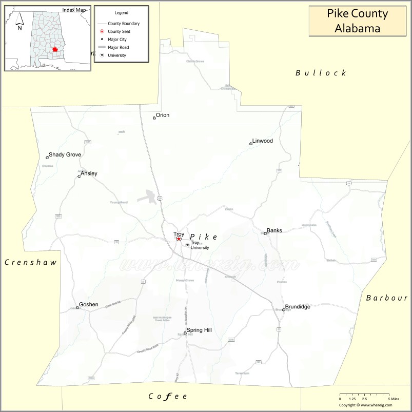
About Pike County Map, Alabama: The map showing the county boundary, county seat, major cities, highways, water bodies and neighbouring counties.
Most Viewed Links
Map of Pike County, Alabama
Pike County is a county located in the U.S. state of Alabama. It`s county seat is Troy. As per 2020 census, the population of Pike County was 32991 and population density of Pike was 49.1square miles. According to the United States Census Bureau, the county has a total area of 672.09 sq mi (1,741 km2). Pike County was established on 1821.
Pike County Facts
| Continent | North America |
| Country | United States |
| State | Alabama |
| County Seat | Troy |
| Largest City/Town | Troy |
| Established | December 17, 1821 |
| Total Area | 673 sq mi (1,743 sq km) |
| Land Area | 672 sq mi (1,740 sq km) |
| Water Area | 1 sq mi (3 sq km) |
| Population | 33,009 (Census 2020) |
| Population Density | 49 people per sq mi |
| Time Zone | Central Time Zone (CT) |
| Major Highways | US 29, US 231, US 331, AL 10, AL 87, AL 93 |
| Major Rivers | Conecuh River, Pea River, Pike County Lake tributaries |
| Neighboring Counties | Montgomery County, Bullock County, Barbour County, Dale County, Coffee County, Crenshaw County |
| Famous For | Troy University, Pioneer Museum of Alabama, agriculture, and higher education |
| Top Attractions | Troy University, Pioneer Museum of Alabama, Pike County Lake, Janice Hawkins Park, and downtown Troy |
| Official Website | Official Website |
About Pike County, Alabama
Pike County is located in southeastern Alabama and was established in 1821. The county seat and largest city is Troy. The county is best known as the home of Troy University, one of Alabama's major public universities. Rolling hills, forests, farmland, and numerous creeks shape the landscape, while education, agriculture, manufacturing, and healthcare are important parts of the local economy.
Cities and Towns in Pike County, Alabama
| City/Town | Population (Census 2020) | Latitude & Longitude |
|---|---|---|
| Troy (county seat) | 19,105 | 31.8088°N, 85.9699°W |
| Brundidge | 1,923 | 31.7202°N, 85.8166°W |
| Banks | 176 | 31.8090°N, 85.7119°W |
| Goshen | 372 | 31.7321°N, 86.1083°W |
| Spring Hill (CDP) | 1,639 | 31.8752°N, 85.9848°W |
| Linwood (CDP) | 118 | 31.8617°N, 85.9251°W |
| Troy Junction (CDP) | 94 | 31.7871°N, 85.9384°W |
Best Golf Courses in Pike County, Alabama
| Golf Course | Location | Latitude & Longitude |
|---|---|---|
| Troy Country Club | Troy | 31.7998°N, 85.9794°W |
| Troy University Golf Course | Troy | 31.8025°N, 85.9567°W |
| Brundidge Country Club | Brundidge | 31.7209°N, 85.8208°W |
| Pike County Golf Club | Troy | 31.8261°N, 85.9905°W |
What are Major Roads and Highways in Pike County
Major highways connect the county to nearby regions and cities.
- US Highway 231 - major north-south route connecting Troy with Montgomery and Dothan
- US Highway 29 - links Troy with Union Springs and Georgia-bound routes
- US Highway 331 - connects Troy with Montgomery and the Florida Panhandle
- Alabama State Route 10 - east-west route serving Brundidge and surrounding communities
- Alabama State Route 87 - connects Troy with Elba and southern Alabama
- Alabama State Route 93 - local connector serving Troy and nearby rural areas
Neighboring Counties of Pike County
- Montgomery County (northwest)
- Bullock County (north)
- Barbour County (east)
- Dale County (southeast)
- Coffee County (southwest)
- Crenshaw County (west)
What are Top Attractions in Pike County, Alabama
The county offers a mix of natural and cultural attractions.
| Main Sight Name | City | Famous For |
|---|---|---|
| Troy University | Troy | Major public university and educational center |
| Pioneer Museum of Alabama | Troy | Historic village and Alabama heritage exhibits |
| Pike County Lake | Troy | Fishing, boating, and outdoor recreation |
| Janice Hawkins Cultural Arts Park | Troy | Public art, sculptures, and community events |
| Downtown Troy Historic District | Troy | Historic buildings, shopping, and dining |
| Troy Arboretum | Troy | Nature trails and native plant collections |
| Butter and Egg Adventures | Troy | Outdoor adventure and team-building activities |
| Johnson Center for the Arts | Troy | Regional art exhibitions and cultural programs |
| Brundidge Historical Museum | Brundidge | Local history and folk culture exhibits |
| We Piddle Around Theater | Brundidge | Community theater and entertainment |
| Conecuh River Corridor | Countywide | Fishing, wildlife viewing, and scenic landscapes |
| Goshen Historic Area | Goshen | Historic rural Alabama heritage |
Distance from Pike County to Nearby Cities
The following distances are measured by road (driving).
- Troy to Brundidge (Pike County), Alabama - 12 mi (19 km)
- Troy to Goshen (Pike County), Alabama - 10 mi (16 km)
- Troy to Ozark (Dale County), Alabama - 33 mi (53 km)
- Troy to Enterprise (Coffee County), Alabama - 34 mi (55 km)
- Troy to Union Springs (Bullock County), Alabama - 35 mi (56 km)
- Troy to Eufaula (Barbour County), Alabama - 49 mi (79 km)
- Troy to Greenville (Butler County), Alabama - 39 mi (63 km)
- Troy to Montgomery (Montgomery County), Alabama - 51 mi (82 km)
- Troy to Dothan (Houston County), Alabama - 56 mi (90 km)
- Troy to Auburn (Lee County), Alabama - 61 mi (98 km)
- Troy to Andalusia (Covington County), Alabama - 62 mi (100 km)
- Troy to Birmingham (Jefferson County), Alabama - 136 mi (219 km)
- Troy to Mobile (Mobile County), Alabama - 165 mi (266 km)
- Troy to Panama City, Florida - 118 mi (190 km)
Nearest Airports
Nearest airport of Pike is Montgomery Regional Airport (MGM / KMGM).
References
- QuickFacts - U.S. Census Bureau
- United States Census Bureau
- United States Geological Survey (USGS)
- National Geodetic Survey
- Official County Website
- Autauga County Map
- Baldwin County Map
- Barbour County Map
- Bibb County Map
- Blount County Map
- Bullock County Map
- Butler County Map
- Calhoun County Map
- Chambers County Map
- Cherokee County Map
- Chilton County Map
- Choctaw County Map
- Clarke County Map
- Clay County Map
- Cleburne County Map
- Coffee County Map
- Colbert County Map
- Conecuh County Map
- Coosa County Map
- Covington County Map
- Crenshaw County Map
- Cullman County Map
- Dale County Map
- Dallas County Map
- DeKalb County Map
- Elmore County Map
- Escambia County Map
- Etowah County Map
- Fayette County Map
- Franklin County Map
- Geneva County Map
- Greene County Map
- Hale County Map
- Henry County Map
- Houston County Map
- Jackson County Map
- Jefferson County Map
- Lamar County Map
- Lauderdale County Map
- Lawrence County Map
- Lee County Map
- Limestone County Map
- Lowndes County Map
- Macon County Map
- Madison County Map
- Marengo County Map
- Marion County Map
- Marshall County Map
- Mobile County Map
- Monroe County Map
- Montgomery County Map
- Morgan County Map
- Perry County Map
- Pickens County Map
- Pike County Map
- Randolph County Map
- Russell County Map
- St Clair County Map
- Shelby County Map
- Sumter County Map
- Talladega County Map
- Tallapoosa County Map
- Tuscaloosa County Map
- Walker County Map
- Washington County Map
- Wilcox County Map
- Winston County Map
- Alabama Counties
- Alaska boroughs
- Arizona Counties
- Arkansas Counties
- California County Map
- Colorado Counties
- Connecticut Counties
- Delaware Counties
- Florida County Map
- Georgia County Map
- Hawaii Counties
- Idaho Counties
- Illinois Counties
- Indiana Counties
- Iowa Counties
- Kansas Counties
- Kentucky Counties
- Louisiana Counties
- Maine Counties
- Maryland Counties
- Massachusetts Counties
- Michigan County Map
- Minnesota Counties
- Mississippi Counties
- Missouri Counties
- Montana Counties
- Nebraska Counties
- Nevada Counties
- New York Counties
- New Hampshire Counties
- New Jersey Counties
- New Mexico Counties
- North Carolina Counties
- North Dakota Counties
- Ohio County Map
- Oklahoma Counties
- Oregon Counties
- Pennsylvania Counties
- Rhode Island Counties
- South Carolina Counties
- South Dakota Counties
- Map of Tennessee
- Texas County Map
- Utah Counties
- Vermont Counties
- Virginia Counties
- Washington Counties
- West Virginia Counties
- Wisconsin Counties
- Wyoming Counties