Map of DeKalb County - DeKalb County is a county located in the U.S. state of Alabama. DeKalb County Map showing cities, highways, important places and water bodies. Get Where is DeKalb County located in the map, major cities in DeKalb county, population, areas, and places of interest.
DeKalb County Map, Alabama
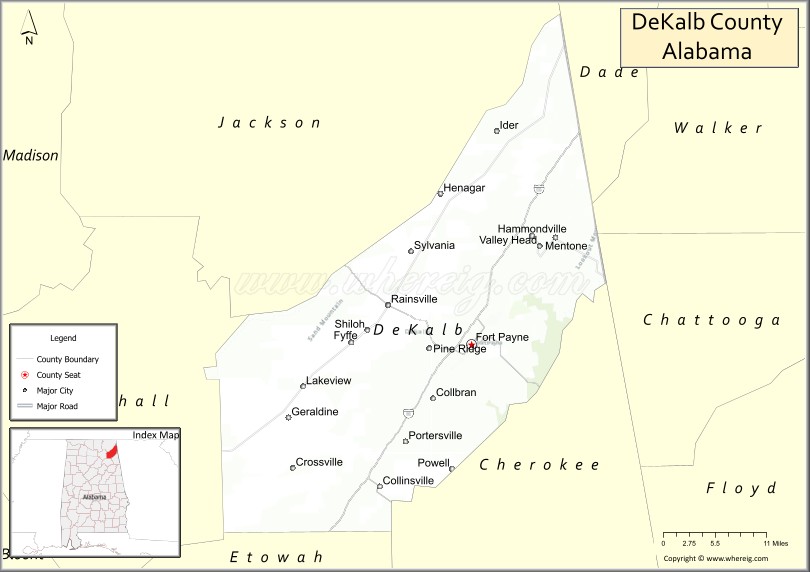
About DeKalb County Map, Alabama: The map showing the county boundary, county seat, major cities, highways, water bodies and neighbouring counties.
Most Viewed Links
Map of DeKalb County, Alabama
DeKalb County is a county located in the U.S. state of Alabama. It`s county seat is Fort Payne. As per 2020 census, the population of DeKalb County was 71813 and population density of DeKalb was 92.4square miles. According to the United States Census Bureau, the county has a total area of 777.09 sq mi (2,013 km2). DeKalb County was established on 1836.
DeKalb County Facts
| Continent | North America |
| Country | United States |
| State | Alabama |
| County Seat | Fort Payne |
| Largest City/Town | Fort Payne |
| Established | January 9, 1836 |
| Total Area | 779 sq mi (2,018 sq km) |
| Land Area | 777 sq mi (2,012 sq km) |
| Water Area | 2 sq mi (5 sq km) |
| Population | 71,608 (Census 2020) |
| Population Density | 92 people per sq mi |
| Time Zone | Central Time Zone (CT) |
| Major Highways | Interstate 59, US 11, US 411, AL 35, AL 68, AL 75, AL 117 |
| Major Rivers | Little River, Tennessee River (near county boundary) |
| Neighboring Counties | Jackson County, Cherokee County, Etowah County, Marshall County, Dade County (GA), Walker County (GA), Chattooga County (GA) |
| Famous For | Little River Canyon, Lookout Mountain, Fort Payne, and country music group Alabama |
| Top Attractions | Little River Canyon National Preserve, DeSoto State Park, Little River Falls, Fort Payne Depot Museum, Lookout Mountain |
| Official Website | Official Website |
About DeKalb County, Alabama
DeKalb County is located in northeastern Alabama along the Georgia border and was established in 1836. The county seat and largest city is Fort Payne. Much of the county lies atop Lookout Mountain and Sand Mountain, making it one of Alabama's most scenic regions, with waterfalls, canyons, forests, and outdoor recreation areas attracting visitors throughout the year.
Cities and Towns in DeKalb County, Alabama
| City/Town | Population (Census 2020) | Latitude & Longitude |
|---|---|---|
| Fort Payne (county seat) | 14,877 | 34.4443°N, 85.7194°W |
| Rainsville | 5,505 | 34.4948°N, 85.8472°W |
| Fyffe | 1,018 | 34.4465°N, 85.9044°W |
| Henagar | 2,234 | 34.6351°N, 85.7427°W |
| Collinsville (partly in DeKalb County) | 1,831 | 34.2670°N, 85.8602°W |
| Crossville | 1,862 | 34.2876°N, 85.9905°W |
| Geraldine | 910 | 34.3524°N, 86.0019°W |
| Hammondville | 462 | 34.9080°N, 85.6330°W |
| Ider | 723 | 34.7148°N, 85.6802°W |
| Mentone | 348 | 34.5617°N, 85.5852°W |
| Powell | 1,248 | 34.5334°N, 85.8914°W |
| Sylvania | 2,103 | 34.5605°N, 85.8127°W |
| Valley Head | 558 | 34.5692°N, 85.6169°W |
| Pine Ridge (CDP) | 210 | 34.4668°N, 85.7891°W |
| Shiloh (CDP) | 274 | 34.4358°N, 85.9206°W |
Best Golf Courses in DeKalb County, Alabama
| Golf Course | Location | Latitude & Longitude |
|---|---|---|
| Terrapin Hills Country Club | Fort Payne | 34.4338°N, 85.7242°W |
| DeKalb County Golf Club | Fort Payne | 34.4511°N, 85.7408°W |
| Dogwood Hills Golf Resort | Fort Payne | 34.4547°N, 85.7061°W |
What are Major Roads and Highways in DeKalb County
Major highways connect the county to nearby regions and cities.
- Interstate 59 - major north-south interstate connecting Fort Payne with Birmingham and Chattanooga
- US Highway 11 - historic route serving Fort Payne and Valley Head
- US Highway 411 - connects Fort Payne with Gadsden and Tennessee communities
- Alabama State Route 35 - scenic route connecting Fort Payne with Rainsville and Scottsboro
- Alabama State Route 68 - crosses the county through Crossville and Collinsville
- Alabama State Route 75 - links Rainsville with Albertville and Georgia
- Alabama State Route 117 - scenic highway through Lookout Mountain communities
Neighboring Counties of DeKalb County
- Jackson County (west and northwest)
- Cherokee County (south)
- Etowah County (southwest)
- Marshall County (west)
- Dade County, Georgia (northeast)
- Walker County, Georgia (east)
- Chattooga County, Georgia (southeast)
What are Top Attractions in DeKalb County, Alabama
The county offers a mix of natural and cultural attractions.
| Main Sight Name | City | Famous For |
|---|---|---|
| Little River Canyon National Preserve | Fort Payne Area | Deep canyon, scenic overlooks, and hiking trails |
| Little River Falls | Fort Payne Area | One of Alabama's most photographed waterfalls |
| DeSoto State Park | Fort Payne Area | Waterfalls, cabins, hiking, and camping |
| Lookout Mountain | Mentone | Scenic mountain views and outdoor recreation |
| Fort Payne Depot Museum | Fort Payne | Railroad history and local heritage |
| Orbix Hot Glass | Fort Payne | Glassblowing demonstrations and art gallery |
| Alabama Fan Club and Museum | Fort Payne | Dedicated to the country music group Alabama |
| DeSoto Falls | Mentone | One of the tallest waterfalls in Alabama |
| Mentone Historic District | Mentone | Mountain village charm and arts community |
| Little River Canyon Center | Fort Payne Area | Educational exhibits and canyon information |
| Buck's Pocket State Park | Geraldine Area | Scenic overlooks and hiking trails |
| Fort Payne Opera House | Fort Payne | Historic performance venue |
Distance from DeKalb County to Nearby Cities
The following distances are measured by road (driving).
- Fort Payne to Rainsville (DeKalb County), Alabama - 10 mi (16 km)
- Fort Payne to Mentone (DeKalb County), Alabama - 16 mi (26 km)
- Fort Payne to Sylvania (DeKalb County), Alabama - 14 mi (23 km)
- Fort Payne to Scottsboro (Jackson County), Alabama - 34 mi (55 km)
- Fort Payne to Gadsden (Etowah County), Alabama - 42 mi (68 km)
- Fort Payne to Centre (Cherokee County), Alabama - 29 mi (47 km)
- Fort Payne to Albertville (Marshall County), Alabama - 37 mi (60 km)
- Fort Payne to Chattanooga, Tennessee - 43 mi (69 km)
- Fort Payne to Rome, Georgia - 48 mi (77 km)
- Fort Payne to Huntsville (Madison County), Alabama - 68 mi (109 km)
- Fort Payne to Birmingham (Jefferson County), Alabama - 92 mi (148 km)
- Fort Payne to Atlanta, Georgia - 118 mi (190 km)
- Fort Payne to Nashville, Tennessee - 138 mi (222 km)
FAQs about DeKalb County
DeKalb County is located in northeastern Alabama along the Georgia border in the Appalachian Highlands region.
DeKalb County had a population of 71,608 according to the 2020 United States Census.
DeKalb County is known for Little River Canyon National Preserve, DeSoto State Park, Lookout Mountain, and its connection to the country music group Alabama.
The county is served by Interstate 59, US Highways 11 and 411, and Alabama State Routes 35, 68, 75, and 117.
Yes. DeKalb County offers golf at Terrapin Hills Country Club, DeKalb County Golf Club, and Dogwood Hills Golf Resort.
References
- QuickFacts - U.S. Census Bureau
- United States Census Bureau
- United States Geological Survey (USGS)
- National Geodetic Survey
- Official County Website
- Autauga County Map
- Baldwin County Map
- Barbour County Map
- Bibb County Map
- Blount County Map
- Bullock County Map
- Butler County Map
- Calhoun County Map
- Chambers County Map
- Cherokee County Map
- Chilton County Map
- Choctaw County Map
- Clarke County Map
- Clay County Map
- Cleburne County Map
- Coffee County Map
- Colbert County Map
- Conecuh County Map
- Coosa County Map
- Covington County Map
- Crenshaw County Map
- Cullman County Map
- Dale County Map
- Dallas County Map
- DeKalb County Map
- Elmore County Map
- Escambia County Map
- Etowah County Map
- Fayette County Map
- Franklin County Map
- Geneva County Map
- Greene County Map
- Hale County Map
- Henry County Map
- Houston County Map
- Jackson County Map
- Jefferson County Map
- Lamar County Map
- Lauderdale County Map
- Lawrence County Map
- Lee County Map
- Limestone County Map
- Lowndes County Map
- Macon County Map
- Madison County Map
- Marengo County Map
- Marion County Map
- Marshall County Map
- Mobile County Map
- Monroe County Map
- Montgomery County Map
- Morgan County Map
- Perry County Map
- Pickens County Map
- Pike County Map
- Randolph County Map
- Russell County Map
- St Clair County Map
- Shelby County Map
- Sumter County Map
- Talladega County Map
- Tallapoosa County Map
- Tuscaloosa County Map
- Walker County Map
- Washington County Map
- Wilcox County Map
- Winston County Map
- Alabama Counties
- Alaska boroughs
- Arizona Counties
- Arkansas Counties
- California County Map
- Colorado Counties
- Connecticut Counties
- Delaware Counties
- Florida County Map
- Georgia County Map
- Hawaii Counties
- Idaho Counties
- Illinois Counties
- Indiana Counties
- Iowa Counties
- Kansas Counties
- Kentucky Counties
- Louisiana Counties
- Maine Counties
- Maryland Counties
- Massachusetts Counties
- Michigan County Map
- Minnesota Counties
- Mississippi Counties
- Missouri Counties
- Montana Counties
- Nebraska Counties
- Nevada Counties
- New York Counties
- New Hampshire Counties
- New Jersey Counties
- New Mexico Counties
- North Carolina Counties
- North Dakota Counties
- Ohio County Map
- Oklahoma Counties
- Oregon Counties
- Pennsylvania Counties
- Rhode Island Counties
- South Carolina Counties
- South Dakota Counties
- Map of Tennessee
- Texas County Map
- Utah Counties
- Vermont Counties
- Virginia Counties
- Washington Counties
- West Virginia Counties
- Wisconsin Counties
- Wyoming Counties