Map of Clay County - Clay County is a county located in the U.S. state of Alabama. Clay County Map showing cities, highways, important places and water bodies. Get Where is Clay County located in the map, major cities in Clay county, population, areas, and places of interest.
Clay County Map, Alabama
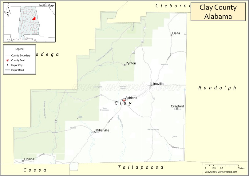
About Clay County Map, Alabama: The map showing the county boundary, county seat, major cities, highways, water bodies and neighbouring counties.
Most Viewed Links
Map of Clay County, Alabama
Clay County is a county located in the U.S. state of Alabama. It`s county seat is Ashland. As per 2020 census, the population of Clay County was 14190 and population density of Clay was 23.5square miles. According to the United States Census Bureau, the county has a total area of 603.96 sq mi (1,564 km2). Clay County was established on 1866.
Clay County Facts
| Continent | North America |
| Country | United States |
| State | Alabama |
| County Seat | Ashland |
| Largest City/Town | Lineville |
| Established | December 7, 1866 |
| Total Area | 606 sq mi (1,570 sq km) |
| Land Area | 604 sq mi (1,564 sq km) |
| Water Area | 2 sq mi (5 sq km) |
| Population | 14,236 (Census 2020) |
| Population Density | 24 people per sq mi |
| Time Zone | Central Time Zone (CT) |
| Major Highways | AL 9, AL 49, AL 77, AL 148 |
| Major Rivers | Tallapoosa River, Little Tallapoosa River |
| Neighboring Counties | Cleburne County, Randolph County, Tallapoosa County, Coosa County, Talladega County |
| Famous For | Cheaha region scenery, Talladega National Forest, Lake Wedowee area access, and outdoor recreation |
| Top Attractions | Cheaha State Park, Talladega National Forest, Pinhoti Trail, Ashland Historic District, Lineville Heritage Sites |
| Official Website | Official Website |
About Clay County, Alabama
Clay County is located in east-central Alabama and was established in 1866. The county seat is Ashland, while Lineville is the largest municipality. The county lies within the southern Appalachian foothills and contains portions of the Talladega National Forest, offering mountain scenery, forests, rivers, and abundant outdoor recreation opportunities.
Cities and Towns in Clay County, Alabama
| City/Town | Population (Census 2020) | Latitude & Longitude |
|---|---|---|
| Ashland (county seat) | 2,037 | 33.2732°N, 85.8369°W |
| Lineville | 2,395 | 33.3101°N, 85.7541°W |
| Delta (CDP) | 143 | 33.4325°N, 85.7144°W |
| Hollins (CDP) | 545 | 33.1224°N, 86.1186°W |
Best Golf Courses in Clay County, Alabama
| Golf Course | Location | Latitude & Longitude |
|---|---|---|
| Lake Wedowee Golf Club | Lineville Area | 33.3367°N, 85.6675°W |
| Clay County Country Club | Ashland | 33.2765°N, 85.8482°W |
What are Major Roads and Highways in Clay County
Major highways connect the county to nearby regions and cities.
- Alabama State Route 9 - north-south route connecting Lineville, Ashland, and Cleburne County
- Alabama State Route 49 - links Lineville with Tallapoosa County and Randolph County
- Alabama State Route 77 - connects Ashland with Talladega County and Randolph County
- Alabama State Route 148 - serves communities in the central portion of the county
Neighboring Counties of Clay County
- Cleburne County (north)
- Randolph County (east)
- Tallapoosa County (southeast)
- Coosa County (southwest)
- Talladega County (west)
What are Top Attractions in Clay County, Alabama
The county offers a mix of natural and cultural attractions.
| Main Sight Name | City | Famous For |
|---|---|---|
| Cheaha State Park | Delta Area | Highest point in Alabama and scenic mountain views |
| Talladega National Forest | Countywide | Hiking, camping, wildlife viewing, and outdoor recreation |
| Pinhoti National Recreation Trail | Delta Area | Long-distance hiking through mountain landscapes |
| Cheaha Lake Recreation Area | Delta Area | Swimming, fishing, and picnicking |
| Ashland Historic District | Ashland | Historic downtown architecture and local heritage |
| Clay County Courthouse | Ashland | Historic county landmark |
| Lineville Historic Downtown | Lineville | Local shops and historic buildings |
| Lake Wedowee Access Areas | Eastern Clay County | Boating, fishing, and lakeside recreation |
| Hollins Wildlife Areas | Hollins | Outdoor recreation and nature viewing |
| Cheaha Falls Area | Delta Area | Scenic waterfall and hiking opportunities |
| Tallapoosa River Scenic Corridor | Countywide | Fishing and river recreation |
| Clay County Museum | Ashland | Local history exhibits and artifacts |
Distance from Clay County to Nearby Cities
The following distances are measured by road (driving).
- Ashland to Lineville (Clay County), Alabama - 7 mi (11 km)
- Ashland to Wedowee (Randolph County), Alabama - 20 mi (32 km)
- Ashland to Heflin (Cleburne County), Alabama - 35 mi (56 km)
- Ashland to Alexander City (Tallapoosa County), Alabama - 31 mi (50 km)
- Ashland to Talladega (Talladega County), Alabama - 37 mi (60 km)
- Ashland to Sylacauga (Talladega County), Alabama - 40 mi (64 km)
- Ashland to Anniston (Calhoun County), Alabama - 47 mi (76 km)
- Ashland to Auburn (Lee County), Alabama - 56 mi (90 km)
- Ashland to Opelika (Lee County), Alabama - 60 mi (97 km)
- Ashland to Birmingham (Jefferson County), Alabama - 79 mi (127 km)
- Ashland to Montgomery (Montgomery County), Alabama - 91 mi (146 km)
- Ashland to Columbus, Georgia - 85 mi (137 km)
- Ashland to Atlanta, Georgia - 111 mi (179 km)
References
- QuickFacts - U.S. Census Bureau
- United States Census Bureau
- United States Geological Survey (USGS)
- National Geodetic Survey
- Official County Website
- Autauga County Map
- Baldwin County Map
- Barbour County Map
- Bibb County Map
- Blount County Map
- Bullock County Map
- Butler County Map
- Calhoun County Map
- Chambers County Map
- Cherokee County Map
- Chilton County Map
- Choctaw County Map
- Clarke County Map
- Clay County Map
- Cleburne County Map
- Coffee County Map
- Colbert County Map
- Conecuh County Map
- Coosa County Map
- Covington County Map
- Crenshaw County Map
- Cullman County Map
- Dale County Map
- Dallas County Map
- DeKalb County Map
- Elmore County Map
- Escambia County Map
- Etowah County Map
- Fayette County Map
- Franklin County Map
- Geneva County Map
- Greene County Map
- Hale County Map
- Henry County Map
- Houston County Map
- Jackson County Map
- Jefferson County Map
- Lamar County Map
- Lauderdale County Map
- Lawrence County Map
- Lee County Map
- Limestone County Map
- Lowndes County Map
- Macon County Map
- Madison County Map
- Marengo County Map
- Marion County Map
- Marshall County Map
- Mobile County Map
- Monroe County Map
- Montgomery County Map
- Morgan County Map
- Perry County Map
- Pickens County Map
- Pike County Map
- Randolph County Map
- Russell County Map
- St Clair County Map
- Shelby County Map
- Sumter County Map
- Talladega County Map
- Tallapoosa County Map
- Tuscaloosa County Map
- Walker County Map
- Washington County Map
- Wilcox County Map
- Winston County Map
- Alabama Counties
- Alaska boroughs
- Arizona Counties
- Arkansas Counties
- California County Map
- Colorado Counties
- Connecticut Counties
- Delaware Counties
- Florida County Map
- Georgia County Map
- Hawaii Counties
- Idaho Counties
- Illinois Counties
- Indiana Counties
- Iowa Counties
- Kansas Counties
- Kentucky Counties
- Louisiana Counties
- Maine Counties
- Maryland Counties
- Massachusetts Counties
- Michigan County Map
- Minnesota Counties
- Mississippi Counties
- Missouri Counties
- Montana Counties
- Nebraska Counties
- Nevada Counties
- New York Counties
- New Hampshire Counties
- New Jersey Counties
- New Mexico Counties
- North Carolina Counties
- North Dakota Counties
- Ohio County Map
- Oklahoma Counties
- Oregon Counties
- Pennsylvania Counties
- Rhode Island Counties
- South Carolina Counties
- South Dakota Counties
- Map of Tennessee
- Texas County Map
- Utah Counties
- Vermont Counties
- Virginia Counties
- Washington Counties
- West Virginia Counties
- Wisconsin Counties
- Wyoming Counties