Map of Calhoun County - Calhoun County is a county located in the U.S. state of Alabama. Calhoun County Map showing cities, highways, important places and water bodies. Get Where is Calhoun County located in the map, major cities in Calhoun county, population, areas, and places of interest.
Calhoun County Map, Alabama
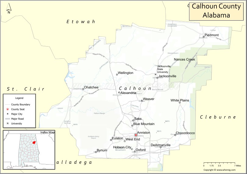
About Calhoun County Map, Alabama: The map showing the county boundary, county seat, major cities, highways, water bodies and neighbouring counties.
Most Viewed Links
Map of Calhoun County, Alabama
Calhoun County is a county located in the U.S. state of Alabama. It`s county seat is Anniston. As per 2020 census, the population of Calhoun County was 115972 and population density of Calhoun was 191.4square miles. According to the United States Census Bureau, the county has a total area of 605.87 sq mi (1,569 km2). Calhoun County was established on 1832.
Calhoun County Facts
| Continent | North America |
| Country | United States |
| State | Alabama |
| County Seat | Anniston |
| Largest City/Town | Anniston |
| Established | December 18, 1832 (as Benton County), renamed Calhoun County in 1858 |
| Total Area | 612 sq mi (1,585 sq km) |
| Land Area | 606 sq mi (1,570 sq km) |
| Water Area | 6 sq mi (16 sq km) |
| Population | 116,441 (Census 2020) |
| Population Density | 192 people per sq mi |
| Time Zone | Central Time Zone (CT) |
| Major Highways | Interstate 20, US 78, US 431, AL 21, AL 202 |
| Major Rivers | Coosa River, Choccolocco Creek |
| Neighboring Counties | Cherokee County, Cleburne County, Talladega County, St. Clair County, Etowah County |
| Famous For | Anniston Army Depot, Talladega National Forest, motorsports, military history, and outdoor recreation |
| Top Attractions | Cheaha State Park, Anniston Museum of Natural History, Berman Museum, Coldwater Mountain Bike Trail, Talladega National Forest |
| Official Website | Official Website |
About Calhoun County, Alabama
Calhoun County is located in east-central Alabama and was established in 1832. The county seat and largest city is Anniston. The county lies between the Appalachian foothills and the Coosa River valley and is known for its military history, outdoor recreation, scenic mountains, and access to the Talladega National Forest.
Cities and Towns in Calhoun County, Alabama
| City/Town | Population (Census 2020) | Latitude & Longitude |
|---|---|---|
| Anniston (county seat) | 21,564 | 33.6598°N, 85.8316°W |
| Jacksonville | 14,385 | 33.8137°N, 85.7614°W |
| Oxford | 21,348 | 33.6143°N, 85.8349°W |
| Piedmont (partly in Calhoun County) | 4,787 | 33.9270°N, 85.6119°W |
| Southside (partly in Calhoun County) | 9,206 | 33.9243°N, 86.0236°W |
| Hobson City | 771 | 33.6190°N, 85.8419°W |
| Weaver | 3,137 | 33.7562°N, 85.8116°W |
| Ohatchee | 1,218 | 33.7818°N, 86.0027°W |
| Saks (CDP) | 9,748 | 33.6705°N, 85.8788°W |
| West End-Cobb Town (CDP) | 3,465 | 33.6438°N, 85.8758°W |
| Alexandria (CDP) | 4,984 | 33.7681°N, 85.8924°W |
Best Golf Courses in Calhoun County, Alabama
| Golf Course | Location | Latitude & Longitude |
|---|---|---|
| Cider Ridge Golf Club | Oxford | 33.6024°N, 85.7524°W |
| Cane Creek Golf Course | Anniston | 33.6838°N, 85.8405°W |
| Silver Lakes Golf Course (RTJ Golf Trail) | Glencoe | 33.9612°N, 85.9465°W |
| Indian Oaks Golf Club | Anniston | 33.7054°N, 85.8092°W |
| Anniston Country Club | Anniston | 33.6338°N, 85.7854°W |
What are Major Roads and Highways in Calhoun County
Major highways connect the county to nearby regions and cities.
- Interstate 20 - major east-west interstate connecting Birmingham and Atlanta
- US Highway 78 - parallel route serving Anniston, Oxford, and surrounding communities
- US Highway 431 - north-south route connecting Anniston with Gadsden and Auburn areas
- Alabama State Route 21 - connects Anniston, Jacksonville, and Piedmont
- Alabama State Route 202 - serves the Anniston-Oxford metropolitan area
Neighboring Counties of Calhoun County
- Cherokee County (north)
- Etowah County (northwest)
- Cleburne County (east)
- Talladega County (south)
- St. Clair County (west)
What are Top Attractions in Calhoun County, Alabama
The county offers a mix of natural and cultural attractions.
| Main Sight Name | City | Famous For |
|---|---|---|
| Cheaha State Park | Delta Area | Highest point in Alabama and mountain scenery |
| Talladega National Forest | Eastern Calhoun County | Hiking, camping, and outdoor recreation |
| Anniston Museum of Natural History | Anniston | Natural history exhibits and collections |
| Berman Museum of World History | Anniston | International artifacts and historical exhibits |
| Coldwater Mountain Bike Trail | Anniston | Nationally recognized mountain biking destination |
| Mountain Longleaf National Wildlife Refuge | Anniston | Protected longleaf pine ecosystem |
| Chief Ladiga Trail | Jacksonville | Popular cycling and walking trail |
| Anniston Army Depot Museum | Anniston | Military history and equipment displays |
| Oxford Lake Park | Oxford | Family recreation and outdoor events |
| Jacksonville State University Campus | Jacksonville | Educational and cultural attractions |
| Choccolocco Park | Oxford | Sports complex and recreation area |
| Janney Furnace Park | Ohatchee | Civil War ironworks historic site |
Distance from Calhoun County to Nearby Cities
The following distances are measured by road (driving).
- Anniston to Oxford (Calhoun County), Alabama - 4 mi (6 km)
- Anniston to Jacksonville (Calhoun County), Alabama - 8 mi (13 km)
- Anniston to Gadsden (Etowah County), Alabama - 31 mi (50 km)
- Anniston to Pell City (St. Clair County), Alabama - 28 mi (45 km)
- Anniston to Talladega (Talladega County), Alabama - 24 mi (39 km)
- Anniston to Piedmont (Calhoun/Cherokee County), Alabama - 27 mi (43 km)
- Anniston to Heflin (Cleburne County), Alabama - 18 mi (29 km)
- Anniston to Birmingham (Jefferson County), Alabama - 63 mi (101 km)
- Anniston to Auburn (Lee County), Alabama - 62 mi (100 km)
- Anniston to Montgomery (Montgomery County), Alabama - 95 mi (153 km)
- Anniston to Huntsville (Madison County), Alabama - 104 mi (167 km)
- Anniston to Atlanta, Georgia - 92 mi (148 km)
- Anniston to Chattanooga, Tennessee - 120 mi (193 km)
Nearest Airports
Nearest airport of Calhoun is Chattanooga (CHA) Airport.
References
- QuickFacts - U.S. Census Bureau
- United States Census Bureau
- United States Geological Survey (USGS)
- National Geodetic Survey
- Official County Website
- Autauga County Map
- Baldwin County Map
- Barbour County Map
- Bibb County Map
- Blount County Map
- Bullock County Map
- Butler County Map
- Calhoun County Map
- Chambers County Map
- Cherokee County Map
- Chilton County Map
- Choctaw County Map
- Clarke County Map
- Clay County Map
- Cleburne County Map
- Coffee County Map
- Colbert County Map
- Conecuh County Map
- Coosa County Map
- Covington County Map
- Crenshaw County Map
- Cullman County Map
- Dale County Map
- Dallas County Map
- DeKalb County Map
- Elmore County Map
- Escambia County Map
- Etowah County Map
- Fayette County Map
- Franklin County Map
- Geneva County Map
- Greene County Map
- Hale County Map
- Henry County Map
- Houston County Map
- Jackson County Map
- Jefferson County Map
- Lamar County Map
- Lauderdale County Map
- Lawrence County Map
- Lee County Map
- Limestone County Map
- Lowndes County Map
- Macon County Map
- Madison County Map
- Marengo County Map
- Marion County Map
- Marshall County Map
- Mobile County Map
- Monroe County Map
- Montgomery County Map
- Morgan County Map
- Perry County Map
- Pickens County Map
- Pike County Map
- Randolph County Map
- Russell County Map
- St Clair County Map
- Shelby County Map
- Sumter County Map
- Talladega County Map
- Tallapoosa County Map
- Tuscaloosa County Map
- Walker County Map
- Washington County Map
- Wilcox County Map
- Winston County Map
- Alabama Counties
- Alaska boroughs
- Arizona Counties
- Arkansas Counties
- California County Map
- Colorado Counties
- Connecticut Counties
- Delaware Counties
- Florida County Map
- Georgia County Map
- Hawaii Counties
- Idaho Counties
- Illinois Counties
- Indiana Counties
- Iowa Counties
- Kansas Counties
- Kentucky Counties
- Louisiana Counties
- Maine Counties
- Maryland Counties
- Massachusetts Counties
- Michigan County Map
- Minnesota Counties
- Mississippi Counties
- Missouri Counties
- Montana Counties
- Nebraska Counties
- Nevada Counties
- New York Counties
- New Hampshire Counties
- New Jersey Counties
- New Mexico Counties
- North Carolina Counties
- North Dakota Counties
- Ohio County Map
- Oklahoma Counties
- Oregon Counties
- Pennsylvania Counties
- Rhode Island Counties
- South Carolina Counties
- South Dakota Counties
- Map of Tennessee
- Texas County Map
- Utah Counties
- Vermont Counties
- Virginia Counties
- Washington Counties
- West Virginia Counties
- Wisconsin Counties
- Wyoming Counties