Map of Barbour County - Barbour County is a county located in the U.S. state of Alabama. Barbour County Map showing cities, highways, important places and water bodies. Get Where is Barbour County located in the map, major cities in Barbour county, population, areas, and places of interest.
Barbour County Map, Alabama
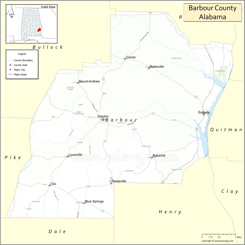
About Barbour County Map, Alabama: The map showing the county boundary, county seat, major cities, highways, water bodies and neighbouring counties.
Most Viewed Links
Map of Barbour County, Alabama
Barbour County is a county located in the U.S. state of Alabama. It`s county seat is Clayton. As per 2020 census, the population of Barbour County was 24964 and population density of Barbour was 28.2square miles. According to the United States Census Bureau, the county has a total area of 884.88 sq mi (2,292 km2). Barbour County was established on 1832.
Barbour County Facts
| County Info | Facts |
|---|---|
| County | Barbour County |
| County Seat | Clayton |
| State | Alabama |
| Country | United States |
| FIPS code | 5 |
| Established | 1832 |
| Area | 884.88 sq mi (2,292 km2) |
| Population | 24964 |
| Density | 28.2 |
| Formed / Origin | Pike County |
Ctities in Barbour county
| City Name | Type | Population (2020) | Pop. Density | Area |
|---|---|---|---|---|
| Bakerhill | Town | 211 | 76.7/sq mi (29.6/km2) | 2.75 sq mi (7.1 km2) |
| Blue Springs | Town | 84 | 29.0/sq mi (11.2/km2) | 2.9 sq mi (7.5 km2) |
| Clayton | Town | 2,265 | 339.1/sq mi (130.9/km2) | 6.68 sq mi (17.3 km2) |
| Clio | City | 1,220 | 121.2/sq mi (46.8/km2) | 10.07 sq mi (26.1 km2) |
| Eufaula | City | 12,882 | 216.9/sq mi (83.7/km2) | 59.39 sq mi (153.8 km2) |
| Louisville | Town | 395 | 143.6/sq mi (55.5/km2) | 2.75 sq mi (7.1 km2) |
Places to Visit in Barbour
Top places to visit in london includes Audra State Park,Adaland Mansion,Tygart Lake State Park,Philippi Covered Bridge,Teter Creek Lake Wildlife,Pleasant Creek Wildlife,Durbin & Greenbrier Valley Railroad,Elkins Depot Welcome Center,Morgantown.
Highways in Barbour
U.S. Highway 82, U.S. Highway 431, State Route 10, State Route 30, State Route 51, State Route 95, State Route 130, State Route 131, State Route 165, State Route 198, State Route 239.
Nearest Airports
Nearest airport of Barbour is North Central West Virginia Airport (CKB / KCKB).
- Autauga County Map
- Baldwin County Map
- Barbour County Map
- Bibb County Map
- Blount County Map
- Bullock County Map
- Butler County Map
- Calhoun County Map
- Chambers County Map
- Cherokee County Map
- Chilton County Map
- Choctaw County Map
- Clarke County Map
- Clay County Map
- Cleburne County Map
- Coffee County Map
- Colbert County Map
- Conecuh County Map
- Coosa County Map
- Covington County Map
- Crenshaw County Map
- Cullman County Map
- Dale County Map
- Dallas County Map
- DeKalb County Map
- Elmore County Map
- Escambia County Map
- Etowah County Map
- Fayette County Map
- Franklin County Map
- Geneva County Map
- Greene County Map
- Hale County Map
- Henry County Map
- Houston County Map
- Jackson County Map
- Jefferson County Map
- Lamar County Map
- Lauderdale County Map
- Lawrence County Map
- Lee County Map
- Limestone County Map
- Lowndes County Map
- Macon County Map
- Madison County Map
- Marengo County Map
- Marion County Map
- Marshall County Map
- Mobile County Map
- Monroe County Map
- Montgomery County Map
- Morgan County Map
- Perry County Map
- Pickens County Map
- Pike County Map
- Randolph County Map
- Russell County Map
- St Clair County Map
- Shelby County Map
- Sumter County Map
- Talladega County Map
- Tallapoosa County Map
- Tuscaloosa County Map
- Walker County Map
- Washington County Map
- Wilcox County Map
- Winston County Map
- Alabama Counties
- Alaska boroughs
- Arizona Counties
- Arkansas Counties
- California County Map
- Colorado Counties
- Connecticut Counties
- Delaware Counties
- Florida County Map
- Georgia County Map
- Hawaii Counties
- Idaho Counties
- Illinois Counties
- Indiana Counties
- Iowa Counties
- Kansas Counties
- Kentucky Counties
- Louisiana Counties
- Maine Counties
- Maryland Counties
- Massachusetts Counties
- Michigan County Map
- Minnesota Counties
- Mississippi Counties
- Missouri Counties
- Montana Counties
- Nebraska Counties
- Nevada Counties
- New York Counties
- New Hampshire Counties
- New Jersey Counties
- New Mexico Counties
- North Carolina Counties
- North Dakota Counties
- Ohio County Map
- Oklahoma Counties
- Oregon Counties
- Pennsylvania Counties
- Rhode Island Counties
- South Carolina Counties
- South Dakota Counties
- Map of Tennessee
- Texas County Map
- Utah Counties
- Vermont Counties
- Virginia Counties
- Washington Counties
- West Virginia Counties
- Wisconsin Counties
- Wyoming Counties