Map of Dale County - Dale County is a county located in the U.S. state of Alabama. Dale County Map showing cities, highways, important places and water bodies. Get Where is Dale County located in the map, major cities in Dale county, population, areas, and places of interest.
Dale County Map, Alabama
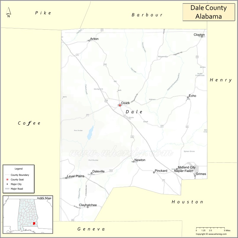
About Dale County Map, Alabama: The map showing the county boundary, county seat, major cities, highways, water bodies and neighbouring counties.
Most Viewed Links
Map of Dale County, Alabama
Dale County is a county located in the U.S. state of Alabama. It`s county seat is Ozark. As per 2020 census, the population of Dale County was 49342 and population density of Dale was 87.9square miles. According to the United States Census Bureau, the county has a total area of 561.15 sq mi (1,453 km2). Dale County was established on 1824.
Dale County Facts
| Continent | North America |
| Country | United States |
| State | Alabama |
| County Seat | Ozark |
| Largest City/Town | Ozark |
| Established | December 22, 1824 |
| Total Area | 563 sq mi (1,458 sq km) |
| Land Area | 561 sq mi (1,453 sq km) |
| Water Area | 2 sq mi (5 sq km) |
| Population | 49,326 (Census 2020) |
| Population Density | 88 people per sq mi |
| Time Zone | Central Time Zone (CT) |
| Major Highways | US 231, US 84, US 27, AL 85, AL 123, AL 51 |
| Major Rivers | Choctawhatchee River, Pea River, Little Choctawhatchee River |
| Neighboring Counties | Barbour County, Henry County, Geneva County, Coffee County, Pike County, Houston County |
| Famous For | Fort Novosel, Army Aviation training, Ozark, and the Wiregrass region |
| Top Attractions | U.S. Army Aviation Museum, Fort Novosel, Ed Lisenby Lake, Dale County Confederate Soldier Monument, Ozark Historic District |
| Official Website | Official Website |
About Dale County, Alabama
Dale County is located in southeastern Alabama in the Wiregrass region and was established in 1824. The county seat and largest city is Ozark. The county is best known as the home of Fort Novosel, one of the world's leading military aviation training centers, and features rolling farmland, forests, and rivers throughout the region. Population was 49,326 according to the 2020 Census. :contentReference[oaicite:0]{index=0}
Cities and Towns in Dale County, Alabama
| City/Town | Population (Census 2020) | Latitude & Longitude |
|---|---|---|
| Ozark (county seat) | 14,368 | 31.4591°N, 85.6405°W |
| Daleville | 4,866 | 31.3041°N, 85.7138°W |
| Level Plains | 2,085 | 31.2993°N, 85.7775°W |
| Midland City | 2,344 | 31.3191°N, 85.4933°W |
| Napier Field | 404 | 31.3148°N, 85.4558°W |
| Newton | 1,494 | 31.3368°N, 85.6091°W |
| Grimes | 558 | 31.3002°N, 85.5702°W |
| Pinckard | 504 | 31.3094°N, 85.5424°W |
| Clayhatchee | 589 | 31.2368°N, 85.7197°W |
| Ariton | 772 | 31.5963°N, 85.7158°W |
| Echo (CDP) | 249 | 31.4870°N, 85.8710°W |
| Skipperville (CDP) | 123 | 31.5692°N, 85.5427°W |
Best Golf Courses in Dale County, Alabama
| Golf Course | Location | Latitude & Longitude |
|---|---|---|
| Silver Wings Golf Course | Fort Novosel | 31.3450°N, 85.7150°W |
| Ozark Country Club | Ozark | 31.4568°N, 85.6593°W |
| Daleville Country Club | Daleville | 31.3137°N, 85.7056°W |
| Whispering Pines Golf Course | Fort Novosel | 31.3381°N, 85.7094°W |
What are Major Roads and Highways in Dale County
Major highways connect the county to nearby regions and cities.
- US Highway 231 - major north-south route connecting Ozark with Montgomery and Dothan
- US Highway 84 - east-west route connecting Daleville, Enterprise, and Dothan
- US Highway 27 - connects Ozark with Troy and Florida
- Alabama State Route 85 - serves Fort Novosel and Daleville
- Alabama State Route 123 - links Ozark with Geneva County and Houston County
- Alabama State Route 51 - connects Ariton with Coffee and Barbour counties
Neighboring Counties of Dale County
- Barbour County (north)
- Pike County (northwest)
- Coffee County (west)
- Geneva County (southwest)
- Houston County (south)
- Henry County (east)
What are Top Attractions in Dale County, Alabama
The county offers a mix of natural and cultural attractions.
| Main Sight Name | City | Famous For |
|---|---|---|
| U.S. Army Aviation Museum | Fort Novosel | Historic military aircraft and aviation exhibits |
| Fort Novosel | Daleville | Major Army aviation training installation |
| Ed Lisenby Lake | Ozark | Fishing, boating, and outdoor recreation |
| Ozark Historic District | Ozark | Historic architecture and downtown heritage |
| Dale County Confederate Soldier Monument | Ozark | Historic landmark in the courthouse square |
| Johnny Henderson Family Park | Nearby Enterprise Area | Large recreation complex and walking trails |
| Landmark Park | Near Midland City | Living history exhibits and nature trails |
| Fort Novosel Lake Tholocco | Fort Novosel | Fishing, camping, and recreation |
| Ariton Heritage Area | Ariton | Small-town history and local culture |
| Choctawhatchee River | Countywide | Fishing, paddling, and scenic landscapes |
| Pea River | Countywide | Outdoor recreation and wildlife viewing |
| Westgate Softball Complex | Ozark | Regional sports tournaments and events |
Distance from Dale County to Nearby Cities
The following distances are measured by road (driving).
- Ozark to Daleville (Dale County), Alabama - 11 mi (18 km)
- Ozark to Midland City (Dale County), Alabama - 14 mi (23 km)
- Ozark to Newton (Dale County), Alabama - 10 mi (16 km)
- Ozark to Enterprise (Coffee County), Alabama - 22 mi (35 km)
- Ozark to Troy (Pike County), Alabama - 33 mi (53 km)
- Ozark to Dothan (Houston County), Alabama - 20 mi (32 km)
- Ozark to Geneva (Geneva County), Alabama - 32 mi (52 km)
- Ozark to Eufaula (Barbour County), Alabama - 44 mi (71 km)
- Ozark to Elba (Coffee County), Alabama - 33 mi (53 km)
- Ozark to Andalusia (Covington County), Alabama - 55 mi (89 km)
- Ozark to Auburn (Lee County), Alabama - 76 mi (122 km)
- Ozark to Montgomery (Montgomery County), Alabama - 86 mi (138 km)
- Ozark to Panama City, Florida - 89 mi (143 km)
- Ozark to Tallahassee, Florida - 115 mi (185 km)
References
- QuickFacts - U.S. Census Bureau
- United States Census Bureau
- United States Geological Survey (USGS)
- National Geodetic Survey
- Official County Website
- Autauga County Map
- Baldwin County Map
- Barbour County Map
- Bibb County Map
- Blount County Map
- Bullock County Map
- Butler County Map
- Calhoun County Map
- Chambers County Map
- Cherokee County Map
- Chilton County Map
- Choctaw County Map
- Clarke County Map
- Clay County Map
- Cleburne County Map
- Coffee County Map
- Colbert County Map
- Conecuh County Map
- Coosa County Map
- Covington County Map
- Crenshaw County Map
- Cullman County Map
- Dale County Map
- Dallas County Map
- DeKalb County Map
- Elmore County Map
- Escambia County Map
- Etowah County Map
- Fayette County Map
- Franklin County Map
- Geneva County Map
- Greene County Map
- Hale County Map
- Henry County Map
- Houston County Map
- Jackson County Map
- Jefferson County Map
- Lamar County Map
- Lauderdale County Map
- Lawrence County Map
- Lee County Map
- Limestone County Map
- Lowndes County Map
- Macon County Map
- Madison County Map
- Marengo County Map
- Marion County Map
- Marshall County Map
- Mobile County Map
- Monroe County Map
- Montgomery County Map
- Morgan County Map
- Perry County Map
- Pickens County Map
- Pike County Map
- Randolph County Map
- Russell County Map
- St Clair County Map
- Shelby County Map
- Sumter County Map
- Talladega County Map
- Tallapoosa County Map
- Tuscaloosa County Map
- Walker County Map
- Washington County Map
- Wilcox County Map
- Winston County Map
- Alabama Counties
- Alaska boroughs
- Arizona Counties
- Arkansas Counties
- California County Map
- Colorado Counties
- Connecticut Counties
- Delaware Counties
- Florida County Map
- Georgia County Map
- Hawaii Counties
- Idaho Counties
- Illinois Counties
- Indiana Counties
- Iowa Counties
- Kansas Counties
- Kentucky Counties
- Louisiana Counties
- Maine Counties
- Maryland Counties
- Massachusetts Counties
- Michigan County Map
- Minnesota Counties
- Mississippi Counties
- Missouri Counties
- Montana Counties
- Nebraska Counties
- Nevada Counties
- New York Counties
- New Hampshire Counties
- New Jersey Counties
- New Mexico Counties
- North Carolina Counties
- North Dakota Counties
- Ohio County Map
- Oklahoma Counties
- Oregon Counties
- Pennsylvania Counties
- Rhode Island Counties
- South Carolina Counties
- South Dakota Counties
- Map of Tennessee
- Texas County Map
- Utah Counties
- Vermont Counties
- Virginia Counties
- Washington Counties
- West Virginia Counties
- Wisconsin Counties
- Wyoming Counties