Map of Chilton County - Chilton County is a county located in the U.S. state of Alabama. Chilton County Map showing cities, highways, important places and water bodies. Get Where is Chilton County located in the map, major cities in Chilton county, population, areas, and places of interest.
Chilton County Map, Alabama
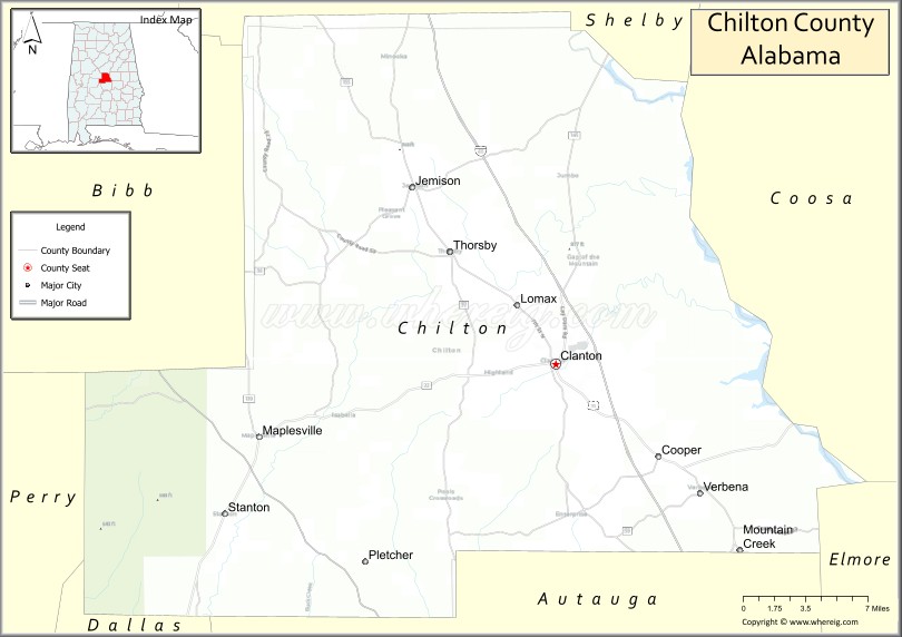
About Chilton County Map, Alabama: The map showing the county boundary, county seat, major cities, highways, water bodies and neighbouring counties.
Most Viewed Links
Map of Chilton County, Alabama
Chilton County is a county located in the U.S. state of Alabama. It`s county seat is Clanton. As per 2020 census, the population of Chilton County was 45274 and population density of Chilton was 65.3square miles. According to the United States Census Bureau, the county has a total area of 692.85 sq mi (1,794 km2). Chilton County was established on 1868.
Chilton County Facts
| Continent | North America |
| Country | United States |
| State | Alabama |
| County Seat | Clanton |
| Largest City/Town | Clanton |
| Established | December 30, 1868 |
| Total Area | 701 sq mi (1,816 sq km) |
| Land Area | 693 sq mi (1,795 sq km) |
| Water Area | 8 sq mi (21 sq km) |
| Population | 45,014 (Census 2020) |
| Population Density | 65 people per sq mi |
| Time Zone | Central Time Zone (CT) |
| Major Highways | Interstate 65, US 31, AL 22, AL 145, AL 155 |
| Major Rivers | Coosa River, Alabama River, Mulberry Creek |
| Neighboring Counties | Shelby County, Bibb County, Perry County, Dallas County, Autauga County, Elmore County, Coosa County |
| Famous For | Peach orchards, peach products, farming, and central Alabama location |
| Top Attractions | Peach Park, Lay Lake, Higgins Ferry Park, Clanton Confederate Memorial Park, Chilton County Peach Festival |
| Official Website | Official Website |
About Chilton County, Alabama
Chilton County is located in central Alabama and was established in 1868. The county seat and largest city is Clanton. The county is widely known as Alabama's peach-producing center and features rolling hills, agricultural landscapes, rivers, lakes, and a strong farming tradition that continues to shape the local economy.
Cities and Towns in Chilton County, Alabama
| City/Town | Population (Census 2020) | Latitude & Longitude |
|---|---|---|
| Clanton (county seat) | 8,768 | 32.8387°N, 86.6294°W |
| Calera (partly in Chilton County) | 16,949 | 33.1029°N, 86.7536°W |
| Jemison | 2,642 | 32.9593°N, 86.7461°W |
| Maplesville | 637 | 32.7887°N, 86.8736°W |
| Thorsby | 2,058 | 32.9151°N, 86.7153°W |
| Verbena | 383 | 32.7535°N, 86.5111°W |
| Billingsley | 125 | 32.6596°N, 86.7119°W |
| Mountain Creek (CDP) | 74 | 32.7862°N, 86.4744°W |
Best Golf Courses in Chilton County, Alabama
| Golf Course | Location | Latitude & Longitude |
|---|---|---|
| Timberline Golf Club | Calera | 33.1127°N, 86.7658°W |
| Chilton County Country Club | Clanton | 32.8408°N, 86.6465°W |
| Maplesville Country Club | Maplesville | 32.7925°N, 86.8712°W |
What are Major Roads and Highways in Chilton County
Major highways connect the county to nearby regions and cities.
- Interstate 65 - major north-south interstate connecting Birmingham and Montgomery through Chilton County
- US Highway 31 - historic route serving Clanton, Jemison, and Thorsby
- Alabama State Route 22 - east-west route connecting Clanton with Selma and Rockford
- Alabama State Route 145 - links Clanton with Shelby County and central Alabama communities
- Alabama State Route 155 - serves eastern parts of the county and provides access to Lay Lake
Neighboring Counties of Chilton County
- Shelby County (north)
- Coosa County (east)
- Elmore County (southeast)
- Autauga County (south)
- Dallas County (southwest)
- Perry County (west)
- Bibb County (northwest)
What are Top Attractions in Chilton County, Alabama
The county offers a mix of natural and cultural attractions.
| Main Sight Name | City | Famous For |
|---|---|---|
| Peach Park | Clanton | Fresh peaches, ice cream, and family-friendly attractions |
| Lay Lake | Eastern Chilton County | Fishing, boating, and waterfront recreation |
| Higgins Ferry Park | Clanton Area | Lake access, camping, and boat launches |
| Chilton County Peach Festival | Clanton | Annual celebration of local agriculture |
| Clanton Confederate Memorial Park | Clanton | Historic exhibits and military artifacts |
| Minooka Park | Clanton | Community recreation and sports facilities |
| Bird Creek Public Use Area | Verbena Area | Fishing and boating access |
| Coosa River Scenic Areas | Eastern County | Natural scenery and outdoor recreation |
| Thorsby Swedish Heritage Sites | Thorsby | Swedish-American cultural history |
| Jemison Railroad Heritage Area | Jemison | Historic transportation heritage |
| Maplesville Historic Downtown | Maplesville | Small-town Alabama charm |
| Chilton County Courthouse | Clanton | Historic county landmark |
Distance from Chilton County to Nearby Cities
The following distances are measured by road (driving).
- Clanton to Jemison (Chilton County), Alabama - 10 mi (16 km)
- Clanton to Thorsby (Chilton County), Alabama - 8 mi (13 km)
- Clanton to Calera (Shelby County), Alabama - 22 mi (35 km)
- Clanton to Alabaster (Shelby County), Alabama - 28 mi (45 km)
- Clanton to Centreville (Bibb County), Alabama - 35 mi (56 km)
- Clanton to Prattville (Autauga County), Alabama - 31 mi (50 km)
- Clanton to Montgomery (Montgomery County), Alabama - 52 mi (84 km)
- Clanton to Selma (Dallas County), Alabama - 52 mi (84 km)
- Clanton to Alexander City (Tallapoosa County), Alabama - 47 mi (76 km)
- Clanton to Birmingham (Jefferson County), Alabama - 54 mi (87 km)
- Clanton to Hoover (Jefferson County), Alabama - 43 mi (69 km)
- Clanton to Tuscaloosa (Tuscaloosa County), Alabama - 74 mi (119 km)
- Clanton to Auburn (Lee County), Alabama - 68 mi (109 km)
Nearest Airports
Nearest airport of Chilton is Chilton County Airport Auth.
References
- QuickFacts - U.S. Census Bureau
- United States Census Bureau
- United States Geological Survey (USGS)
- National Geodetic Survey
- Official County Website
- Autauga County Map
- Baldwin County Map
- Barbour County Map
- Bibb County Map
- Blount County Map
- Bullock County Map
- Butler County Map
- Calhoun County Map
- Chambers County Map
- Cherokee County Map
- Chilton County Map
- Choctaw County Map
- Clarke County Map
- Clay County Map
- Cleburne County Map
- Coffee County Map
- Colbert County Map
- Conecuh County Map
- Coosa County Map
- Covington County Map
- Crenshaw County Map
- Cullman County Map
- Dale County Map
- Dallas County Map
- DeKalb County Map
- Elmore County Map
- Escambia County Map
- Etowah County Map
- Fayette County Map
- Franklin County Map
- Geneva County Map
- Greene County Map
- Hale County Map
- Henry County Map
- Houston County Map
- Jackson County Map
- Jefferson County Map
- Lamar County Map
- Lauderdale County Map
- Lawrence County Map
- Lee County Map
- Limestone County Map
- Lowndes County Map
- Macon County Map
- Madison County Map
- Marengo County Map
- Marion County Map
- Marshall County Map
- Mobile County Map
- Monroe County Map
- Montgomery County Map
- Morgan County Map
- Perry County Map
- Pickens County Map
- Pike County Map
- Randolph County Map
- Russell County Map
- St Clair County Map
- Shelby County Map
- Sumter County Map
- Talladega County Map
- Tallapoosa County Map
- Tuscaloosa County Map
- Walker County Map
- Washington County Map
- Wilcox County Map
- Winston County Map
- Alabama Counties
- Alaska boroughs
- Arizona Counties
- Arkansas Counties
- California County Map
- Colorado Counties
- Connecticut Counties
- Delaware Counties
- Florida County Map
- Georgia County Map
- Hawaii Counties
- Idaho Counties
- Illinois Counties
- Indiana Counties
- Iowa Counties
- Kansas Counties
- Kentucky Counties
- Louisiana Counties
- Maine Counties
- Maryland Counties
- Massachusetts Counties
- Michigan County Map
- Minnesota Counties
- Mississippi Counties
- Missouri Counties
- Montana Counties
- Nebraska Counties
- Nevada Counties
- New York Counties
- New Hampshire Counties
- New Jersey Counties
- New Mexico Counties
- North Carolina Counties
- North Dakota Counties
- Ohio County Map
- Oklahoma Counties
- Oregon Counties
- Pennsylvania Counties
- Rhode Island Counties
- South Carolina Counties
- South Dakota Counties
- Map of Tennessee
- Texas County Map
- Utah Counties
- Vermont Counties
- Virginia Counties
- Washington Counties
- West Virginia Counties
- Wisconsin Counties
- Wyoming Counties