Map of Geneva County - Geneva County is a county located in the U.S. state of Alabama. Geneva County Map showing cities, highways, important places and water bodies. Get Where is Geneva County located in the map, major cities in Geneva county, population, areas, and places of interest.
Geneva County Map, Alabama
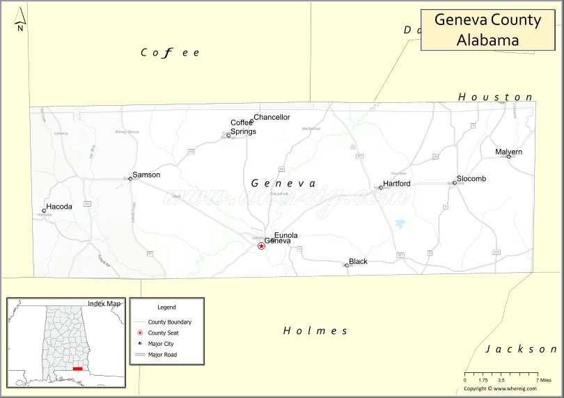
About Geneva County Map, Alabama: The map showing the county boundary, county seat, major cities, highways, water bodies and neighbouring counties.
Most Viewed Links
Map of Geneva County, Alabama
Geneva County is a county located in the U.S. state of Alabama. It`s county seat is Geneva. As per 2020 census, the population of Geneva County was 26701 and population density of Geneva was 46.5square miles. According to the United States Census Bureau, the county has a total area of 574.41 sq mi (1,488 km2). Geneva County was established on 1868.
Geneva County Facts
| Continent | North America |
| Country | United States |
| State | Alabama |
| County Seat | Geneva |
| Largest City/Town | Geneva |
| Established | December 26, 1868 |
| Total Area | 579 sq mi (1,500 sq km) |
| Land Area | 574 sq mi (1,487 sq km) |
| Water Area | 5 sq mi (13 sq km) |
| Population | 26,659 (Census 2020) |
| Population Density | 46 people per sq mi |
| Time Zone | Central Time Zone (CT) |
| Major Highways | US 84, AL 27, AL 52, AL 85, AL 87 |
| Major Rivers | Choctawhatchee River, Pea River |
| Neighboring Counties | Coffee County, Dale County, Houston County, Covington County, Holmes County (FL), Jackson County (FL), Walton County (FL) |
| Famous For | Choctawhatchee River, Geneva State Forest, agriculture, and outdoor recreation |
| Top Attractions | Geneva State Forest, Choctawhatchee River, Pea River, Geneva County Courthouse, Riverwalk Park |
| Official Website | Official Website |
About Geneva County, Alabama
Geneva County is located in southeastern Alabama along the Florida border and was established in 1868. The county seat and largest city is Geneva. The county is known for its fertile farmland, extensive forests, scenic rivers, and outdoor recreation opportunities centered around the Choctawhatchee and Pea rivers that meet in the city of Geneva.
Cities and Towns in Geneva County, Alabama
| City/Town | Population (Census 2020) | Latitude & Longitude |
|---|---|---|
| Geneva (county seat) | 4,237 | 31.0393°N, 85.8635°W |
| Hartford | 2,624 | 31.1024°N, 85.6963°W |
| Samson | 1,889 | 31.1121°N, 86.0472°W |
| Slocomb (partly in Geneva County) | 2,082 | 31.1088°N, 85.5955°W |
| Coffee Springs | 177 | 31.1668°N, 85.9108°W |
| Black (partly in Geneva County) | 207 | 31.0156°N, 85.7449°W |
| Malvern (partly in Geneva County) | 1,215 | 31.1394°N, 85.5207°W |
| Battens Crossroads (CDP) | 147 | 31.0278°N, 85.9436°W |
| Fadette (CDP) | 190 | 31.0334°N, 85.9918°W |
| Kinston (partly in Geneva County) | 540 | 31.2240°N, 85.8780°W |
Best Golf Courses in Geneva County, Alabama
| Golf Course | Location | Latitude & Longitude |
|---|---|---|
| River Oaks Golf Course | Geneva | 31.0438°N, 85.8515°W |
| Hartford Country Club Golf Course | Hartford | 31.0979°N, 85.6882°W |
| Samson Golf and Country Club | Samson | 31.1108°N, 86.0544°W |
What are Major Roads and Highways in Geneva County
Major highways connect the county to nearby regions and cities.
- US Highway 84 - major east-west route connecting Geneva with Enterprise and Dothan
- Alabama State Route 27 - north-south route linking Geneva with Florala and Coffee County
- Alabama State Route 52 - connects Hartford with Dothan and Geneva
- Alabama State Route 85 - serves eastern portions of the county and nearby communities
- Alabama State Route 87 - connects Samson with Opp and Florida communities
Neighboring Counties of Geneva County
- Coffee County (north)
- Dale County (northeast)
- Houston County (east)
- Covington County (west)
- Holmes County, Florida (southwest)
- Jackson County, Florida (south)
- Walton County, Florida (southwest)
What are Top Attractions in Geneva County, Alabama
The county offers a mix of natural and cultural attractions.
| Main Sight Name | City | Famous For |
|---|---|---|
| Geneva State Forest | Geneva Area | Hiking, wildlife viewing, and outdoor recreation |
| Choctawhatchee River | Geneva | Fishing, paddling, and scenic river views |
| Pea River | Geneva | Water recreation and natural beauty |
| Riverwalk Park | Geneva | Walking trails and riverfront recreation |
| Geneva County Courthouse | Geneva | Historic county landmark |
| Hartford Historic District | Hartford | Historic downtown architecture and heritage |
| Samson Community Park | Samson | Outdoor recreation and local events |
| Choctawhatchee River Wildlife Area | Countywide | Birdwatching and wildlife observation |
| Coffee Springs Heritage Area | Coffee Springs | Small-town history and culture |
| Geneva Festival Grounds | Geneva | Annual festivals and community events |
| Hartford City Park | Hartford | Family recreation and sports facilities |
| Fadette Rural Scenic Area | Fadette | Countryside views and agricultural landscapes |
Distance from Geneva County to Nearby Cities
The following distances are measured by road (driving).
- Geneva to Hartford (Geneva County), Alabama - 9 mi (14 km)
- Geneva to Samson (Geneva County), Alabama - 15 mi (24 km)
- Geneva to Slocomb (Geneva County), Alabama - 19 mi (31 km)
- Geneva to Enterprise (Coffee County), Alabama - 28 mi (45 km)
- Geneva to Ozark (Dale County), Alabama - 32 mi (52 km)
- Geneva to Dothan (Houston County), Alabama - 29 mi (47 km)
- Geneva to Andalusia (Covington County), Alabama - 32 mi (52 km)
- Geneva to Opp (Covington County), Alabama - 25 mi (40 km)
- Geneva to Marianna, Florida - 38 mi (61 km)
- Geneva to Bonifay, Florida - 24 mi (39 km)
- Geneva to Panama City, Florida - 73 mi (117 km)
- Geneva to Montgomery (Montgomery County), Alabama - 102 mi (164 km)
- Geneva to Tallahassee, Florida - 103 mi (166 km)
Nearest Airports
Nearest airport of Geneva is Geneva Municipal Airport.
References
- QuickFacts - U.S. Census Bureau
- United States Census Bureau
- United States Geological Survey (USGS)
- National Geodetic Survey
- Official County Website
Nearest Airports
Nearest airport of Geneva is Geneva Municipal Airport.
- Autauga County Map
- Baldwin County Map
- Barbour County Map
- Bibb County Map
- Blount County Map
- Bullock County Map
- Butler County Map
- Calhoun County Map
- Chambers County Map
- Cherokee County Map
- Chilton County Map
- Choctaw County Map
- Clarke County Map
- Clay County Map
- Cleburne County Map
- Coffee County Map
- Colbert County Map
- Conecuh County Map
- Coosa County Map
- Covington County Map
- Crenshaw County Map
- Cullman County Map
- Dale County Map
- Dallas County Map
- DeKalb County Map
- Elmore County Map
- Escambia County Map
- Etowah County Map
- Fayette County Map
- Franklin County Map
- Geneva County Map
- Greene County Map
- Hale County Map
- Henry County Map
- Houston County Map
- Jackson County Map
- Jefferson County Map
- Lamar County Map
- Lauderdale County Map
- Lawrence County Map
- Lee County Map
- Limestone County Map
- Lowndes County Map
- Macon County Map
- Madison County Map
- Marengo County Map
- Marion County Map
- Marshall County Map
- Mobile County Map
- Monroe County Map
- Montgomery County Map
- Morgan County Map
- Perry County Map
- Pickens County Map
- Pike County Map
- Randolph County Map
- Russell County Map
- St Clair County Map
- Shelby County Map
- Sumter County Map
- Talladega County Map
- Tallapoosa County Map
- Tuscaloosa County Map
- Walker County Map
- Washington County Map
- Wilcox County Map
- Winston County Map
- Alabama Counties
- Alaska boroughs
- Arizona Counties
- Arkansas Counties
- California County Map
- Colorado Counties
- Connecticut Counties
- Delaware Counties
- Florida County Map
- Georgia County Map
- Hawaii Counties
- Idaho Counties
- Illinois Counties
- Indiana Counties
- Iowa Counties
- Kansas Counties
- Kentucky Counties
- Louisiana Counties
- Maine Counties
- Maryland Counties
- Massachusetts Counties
- Michigan County Map
- Minnesota Counties
- Mississippi Counties
- Missouri Counties
- Montana Counties
- Nebraska Counties
- Nevada Counties
- New York Counties
- New Hampshire Counties
- New Jersey Counties
- New Mexico Counties
- North Carolina Counties
- North Dakota Counties
- Ohio County Map
- Oklahoma Counties
- Oregon Counties
- Pennsylvania Counties
- Rhode Island Counties
- South Carolina Counties
- South Dakota Counties
- Map of Tennessee
- Texas County Map
- Utah Counties
- Vermont Counties
- Virginia Counties
- Washington Counties
- West Virginia Counties
- Wisconsin Counties
- Wyoming Counties