Map of Elmore County - Elmore County is a county located in the U.S. state of Alabama. Elmore County Map showing cities, highways, important places and water bodies. Get Where is Elmore County located in the map, major cities in Elmore county, population, areas, and places of interest.
Elmore County Map, Alabama
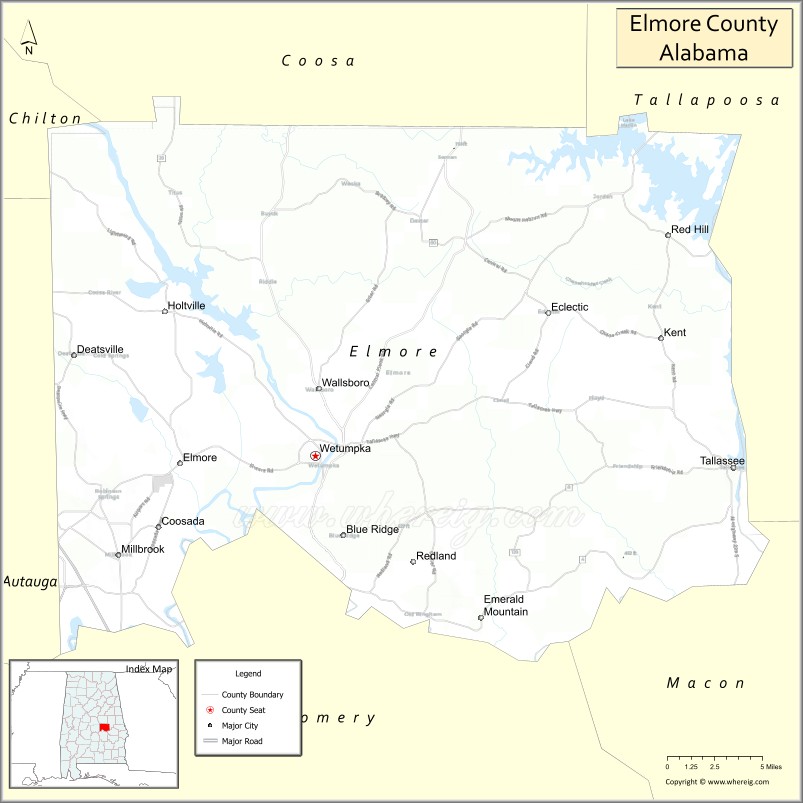
About Elmore County Map, Alabama: The map showing the county boundary, county seat, major cities, highways, water bodies and neighbouring counties.
Most Viewed Links
Map of Elmore County, Alabama
Elmore County is a county located in the U.S. state of Alabama. It`s county seat is Wetumpka. As per 2020 census, the population of Elmore County was 89304 and population density of Elmore was 144.4square miles. According to the United States Census Bureau, the county has a total area of 618.48 sq mi (1,602 km2). Elmore County was established on 1866.
Elmore County Facts
| Continent | North America |
| Country | United States |
| State | Alabama |
| County Seat | Wetumpka |
| Largest City/Town | Wetumpka |
| Established | February 15, 1866 |
| Total Area | 657 sq mi (1,701 sq km) |
| Land Area | 618 sq mi (1,601 sq km) |
| Water Area | 39 sq mi (101 sq km) |
| Population | 87,977 (Census 2020) |
| Population Density | 142 people per sq mi |
| Time Zone | Central Time Zone (CT) |
| Major Highways | Interstate 65, US 231, US 80, AL 14, AL 111, AL 143 |
| Major Rivers | Coosa River, Tallapoosa River, Alabama River |
| Neighboring Counties | Autauga County, Montgomery County, Macon County, Tallapoosa County, Coosa County, Chilton County |
| Famous For | Lake Martin, Wetumpka, Coosa River, historic sites, and outdoor recreation |
| Top Attractions | Wetumpka Impact Crater, Fort Toulouse-Fort Jackson Park, Lake Jordan, Lake Martin, Wind Creek State Park |
| Official Website | Official Website |
About Elmore County, Alabama
Elmore County is located in central Alabama and was established in 1866. The county seat and largest city is Wetumpka. The county is known for its scenic rivers, large recreational lakes, historic landmarks, and rapidly growing communities near the Montgomery metropolitan area. The Coosa and Tallapoosa rivers play a major role in the county's geography and recreation opportunities.
Cities and Towns in Elmore County, Alabama
| City/Town | Population (Census 2020) | Latitude & Longitude |
|---|---|---|
| Wetumpka (county seat) | 7,220 | 32.5437°N, 86.2119°W |
| Tallassee (partly in Elmore County) | 4,763 | 32.5351°N, 85.8955°W |
| Millbrook | 16,762 | 32.4799°N, 86.3619°W |
| Prattville (partly in Elmore County) | 37,781 | 32.4640°N, 86.4597°W |
| Eclectic | 1,193 | 32.6351°N, 86.0341°W |
| Deatsville | 1,679 | 32.6082°N, 86.3955°W |
| Elmore | 1,262 | 32.5385°N, 86.3144°W |
| Coosada | 1,224 | 32.4971°N, 86.3308°W |
| Blue Ridge (CDP) | 1,341 | 32.4926°N, 86.1903°W |
| Emerald Mountain (CDP) | 2,711 | 32.4467°N, 86.1267°W |
| Redland (CDP) | 4,019 | 32.5864°N, 86.1885°W |
| Wallsboro (CDP) | 1,880 | 32.6408°N, 86.1886°W |
| Kowaliga (CDP) | 1,924 | 32.7194°N, 85.9852°W |
Best Golf Courses in Elmore County, Alabama
| Golf Course | Location | Latitude & Longitude |
|---|---|---|
| Robert Trent Jones Golf Trail at Capitol Hill - Judge Course | Prattville Area | 32.4596°N, 86.4472°W |
| Robert Trent Jones Golf Trail at Capitol Hill - Legislator Course | Prattville Area | 32.4596°N, 86.4472°W |
| Robert Trent Jones Golf Trail at Capitol Hill - Senator Course | Prattville Area | 32.4596°N, 86.4472°W |
| Emerald Mountain Golf Club | Wetumpka | 32.4673°N, 86.1445°W |
| Quail Walk Golf Course | Wetumpka | 32.5456°N, 86.2234°W |
| Wynlakes Golf Practice Facility | Eastern Elmore County | 32.4804°N, 86.1531°W |
What are Major Roads and Highways in Elmore County
Major highways connect the county to nearby regions and cities.
- Interstate 65 - major north-south interstate connecting Montgomery, Birmingham, and Mobile
- US Highway 231 - primary route connecting Wetumpka with Montgomery and northern Alabama
- US Highway 80 - serves southern portions of the county near Montgomery
- Alabama State Route 14 - connects Wetumpka with Autauga and Tallapoosa counties
- Alabama State Route 111 - serves Millbrook and nearby communities
- Alabama State Route 143 - links Elmore County with Chilton County and Montgomery County
Neighboring Counties of Elmore County
- Chilton County (northwest)
- Coosa County (north)
- Tallapoosa County (east)
- Macon County (southeast)
- Montgomery County (south)
- Autauga County (west)
What are Top Attractions in Elmore County, Alabama
The county offers a mix of natural and cultural attractions.
| Main Sight Name | City | Famous For |
|---|---|---|
| Wetumpka Impact Crater | Wetumpka | Ancient meteor impact site and geological landmark |
| Fort Toulouse-Fort Jackson Park | Wetumpka | Historic French fort and Creek Indian heritage site |
| Lake Jordan | Wetumpka Area | Boating, fishing, and water recreation |
| Lake Martin | Kowaliga Area | One of Alabama's most popular recreation lakes |
| Wind Creek State Park | Alexander City Area | Camping, boating, and hiking |
| Jasmine Hill Gardens | Wetumpka | Greek-inspired gardens and historic exhibits |
| Coosa River Adventures | Wetumpka | Kayaking and outdoor recreation |
| Gold Star Park | Wetumpka | Riverfront recreation and walking trails |
| Elmore County Museum | Wetumpka | Local history exhibits and artifacts |
| Swayback Bridge Trail | Wetumpka Area | Hiking and scenic views |
| Emerald Mountain Recreation Area | Emerald Mountain | Golf and outdoor activities |
| Historic Downtown Wetumpka | Wetumpka | Shops, restaurants, and historic architecture |
Distance from Elmore County to Nearby Cities
The following distances are measured by road (driving).
- Wetumpka to Millbrook (Elmore County), Alabama - 12 mi (19 km)
- Wetumpka to Eclectic (Elmore County), Alabama - 18 mi (29 km)
- Wetumpka to Tallassee (Elmore County), Alabama - 20 mi (32 km)
- Wetumpka to Prattville (Autauga County), Alabama - 19 mi (31 km)
- Wetumpka to Montgomery (Montgomery County), Alabama - 15 mi (24 km)
- Wetumpka to Clanton (Chilton County), Alabama - 40 mi (64 km)
- Wetumpka to Alexander City (Tallapoosa County), Alabama - 36 mi (58 km)
- Wetumpka to Auburn (Lee County), Alabama - 48 mi (77 km)
- Wetumpka to Troy (Pike County), Alabama - 69 mi (111 km)
- Wetumpka to Birmingham (Jefferson County), Alabama - 92 mi (148 km)
- Wetumpka to Tuscaloosa (Tuscaloosa County), Alabama - 109 mi (175 km)
- Wetumpka to Dothan (Houston County), Alabama - 106 mi (171 km)
- Wetumpka to Columbus, Georgia - 82 mi (132 km)
Nearest Airports
Nearest airport of Elmore is Wetumpka City Airport.
References
- QuickFacts - U.S. Census Bureau
- United States Census Bureau
- United States Geological Survey (USGS)
- National Geodetic Survey
- Official County Website
Nearest Airports
Nearest airport of Elmore is Wetumpka City Airport.
- Autauga County Map
- Baldwin County Map
- Barbour County Map
- Bibb County Map
- Blount County Map
- Bullock County Map
- Butler County Map
- Calhoun County Map
- Chambers County Map
- Cherokee County Map
- Chilton County Map
- Choctaw County Map
- Clarke County Map
- Clay County Map
- Cleburne County Map
- Coffee County Map
- Colbert County Map
- Conecuh County Map
- Coosa County Map
- Covington County Map
- Crenshaw County Map
- Cullman County Map
- Dale County Map
- Dallas County Map
- DeKalb County Map
- Elmore County Map
- Escambia County Map
- Etowah County Map
- Fayette County Map
- Franklin County Map
- Geneva County Map
- Greene County Map
- Hale County Map
- Henry County Map
- Houston County Map
- Jackson County Map
- Jefferson County Map
- Lamar County Map
- Lauderdale County Map
- Lawrence County Map
- Lee County Map
- Limestone County Map
- Lowndes County Map
- Macon County Map
- Madison County Map
- Marengo County Map
- Marion County Map
- Marshall County Map
- Mobile County Map
- Monroe County Map
- Montgomery County Map
- Morgan County Map
- Perry County Map
- Pickens County Map
- Pike County Map
- Randolph County Map
- Russell County Map
- St Clair County Map
- Shelby County Map
- Sumter County Map
- Talladega County Map
- Tallapoosa County Map
- Tuscaloosa County Map
- Walker County Map
- Washington County Map
- Wilcox County Map
- Winston County Map
- Alabama Counties
- Alaska boroughs
- Arizona Counties
- Arkansas Counties
- California County Map
- Colorado Counties
- Connecticut Counties
- Delaware Counties
- Florida County Map
- Georgia County Map
- Hawaii Counties
- Idaho Counties
- Illinois Counties
- Indiana Counties
- Iowa Counties
- Kansas Counties
- Kentucky Counties
- Louisiana Counties
- Maine Counties
- Maryland Counties
- Massachusetts Counties
- Michigan County Map
- Minnesota Counties
- Mississippi Counties
- Missouri Counties
- Montana Counties
- Nebraska Counties
- Nevada Counties
- New York Counties
- New Hampshire Counties
- New Jersey Counties
- New Mexico Counties
- North Carolina Counties
- North Dakota Counties
- Ohio County Map
- Oklahoma Counties
- Oregon Counties
- Pennsylvania Counties
- Rhode Island Counties
- South Carolina Counties
- South Dakota Counties
- Map of Tennessee
- Texas County Map
- Utah Counties
- Vermont Counties
- Virginia Counties
- Washington Counties
- West Virginia Counties
- Wisconsin Counties
- Wyoming Counties