Map of Cleburne County - Cleburne County is a county located in the U.S. state of Alabama. Cleburne County Map showing cities, highways, important places and water bodies. Get Where is Cleburne County located in the map, major cities in Cleburne county, population, areas, and places of interest.
Cleburne County Map, Alabama
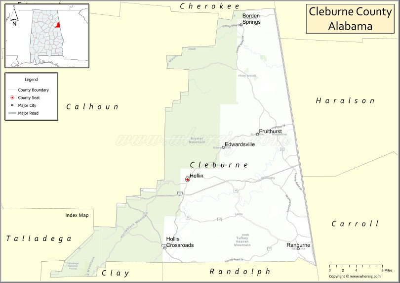
About Cleburne County Map, Alabama: The map showing the county boundary, county seat, major cities, highways, water bodies and neighbouring counties.
Most Viewed Links
Map of Cleburne County, Alabama
Cleburne County is a county located in the U.S. state of Alabama. It`s county seat is Heflin. As per 2020 census, the population of Cleburne County was 15103 and population density of Cleburne was 27square miles. According to the United States Census Bureau, the county has a total area of 560.10 sq mi (1,451 km2). Cleburne County was established on 1866.
Cleburne County Facts
| Continent | North America |
| Country | United States |
| State | Alabama |
| County Seat | Heflin |
| Largest City/Town | Heflin |
| Established | December 6, 1866 |
| Total Area | 561 sq mi (1,453 sq km) |
| Land Area | 560 sq mi (1,450 sq km) |
| Water Area | 1 sq mi (3 sq km) |
| Population | 14,123 (Census 2020) |
| Population Density | 25 people per sq mi |
| Time Zone | Central Time Zone (CT) |
| Major Highways | Interstate 20, US 78, AL 9, AL 46, AL 48 |
| Major Rivers | Tallapoosa River, Little Tallapoosa River |
| Neighboring Counties | Cherokee County, Calhoun County, Clay County, Randolph County, Haralson County (GA), Carroll County (GA) |
| Famous For | Cheaha region, Talladega National Forest, Pinhoti Trail, and Appalachian foothills scenery |
| Top Attractions | Cheaha State Park, Talladega National Forest, Pinhoti Trail, Choccolocco Wildlife Management Area, Lake Cleburne |
| Official Website | Official Website |
About Cleburne County, Alabama
Cleburne County is located in eastern Alabama along the Georgia border and was established in 1866. The county seat and largest city is Heflin. The county is part of the southern Appalachian region and is known for its mountains, forests, hiking trails, scenic drives, and extensive outdoor recreation opportunities within the Talladega National Forest.
Cities and Towns in Cleburne County, Alabama
| City/Town | Population (Census 2020) | Latitude & Longitude |
|---|---|---|
| Heflin (county seat) | 3,431 | 33.6482°N, 85.5877°W |
| Ranburne | 409 | 33.5229°N, 85.3467°W |
| Edwardsville | 181 | 33.7396°N, 85.5444°W |
| Fruithurst | 278 | 33.7320°N, 85.4338°W |
| Muscadine (CDP) | 247 | 33.7488°N, 85.3822°W |
| Bell Mills (CDP) | 120 | 33.6653°N, 85.6591°W |
Best Golf Courses in Cleburne County, Alabama
| Golf Course | Location | Latitude & Longitude |
|---|---|---|
| Cleburne County Golf Club | Heflin | 33.6489°N, 85.6008°W |
| Indian Mountain ATV Park Golf Practice Area | Piedmont Area | 33.9338°N, 85.5611°W |
What are Major Roads and Highways in Cleburne County
Major highways connect the county to nearby regions and cities.
- Interstate 20 - major east-west interstate connecting Birmingham and Atlanta through Heflin
- US Highway 78 - historic route serving Heflin, Fruithurst, and eastern Alabama communities
- Alabama State Route 9 - north-south route connecting Heflin with Cherokee and Clay counties
- Alabama State Route 46 - connects Heflin with Ranburne and the Georgia state line
- Alabama State Route 48 - serves southern portions of the county and connects with Randolph County
Neighboring Counties of Cleburne County
- Cherokee County (north)
- Calhoun County (west)
- Clay County (southwest)
- Randolph County (south)
- Haralson County, Georgia (east)
- Carroll County, Georgia (southeast)
What are Top Attractions in Cleburne County, Alabama
The county offers a mix of natural and cultural attractions.
| Main Sight Name | City | Famous For |
|---|---|---|
| Cheaha State Park | Delta Area | Alabama's highest mountain and scenic overlooks |
| Talladega National Forest | Countywide | Hiking, camping, and wildlife viewing |
| Pinhoti Trail | Countywide | Long-distance hiking through mountain landscapes |
| Choccolocco Wildlife Management Area | Heflin Area | Hunting, fishing, and outdoor recreation |
| Lake Cleburne | Heflin | Fishing and boating opportunities |
| Mountain Longleaf National Wildlife Refuge | Western County | Protected longleaf pine ecosystem |
| Heflin Historic District | Heflin | Historic architecture and local heritage |
| Fruithurst Winery Area | Fruithurst | Agricultural heritage and rural scenery |
| Indian Mountain ATV Park | Piedmont Area | Off-road recreation and outdoor adventures |
| Ranburne Community Park | Ranburne | Family recreation and local events |
| Cleburne County Courthouse | Heflin | Historic county landmark |
| Little Tallapoosa Scenic Areas | Southern County | Natural beauty and river recreation |
Distance from Cleburne County to Nearby Cities
The following distances are measured by road (driving).
- Heflin to Ranburne (Cleburne County), Alabama - 14 mi (23 km)
- Heflin to Fruithurst (Cleburne County), Alabama - 13 mi (21 km)
- Heflin to Anniston (Calhoun County), Alabama - 18 mi (29 km)
- Heflin to Jacksonville (Calhoun County), Alabama - 20 mi (32 km)
- Heflin to Centre (Cherokee County), Alabama - 33 mi (53 km)
- Heflin to Ashland (Clay County), Alabama - 35 mi (56 km)
- Heflin to Wedowee (Randolph County), Alabama - 30 mi (48 km)
- Heflin to Carrollton, Georgia - 28 mi (45 km)
- Heflin to Bremen, Georgia - 18 mi (29 km)
- Heflin to Atlanta, Georgia - 79 mi (127 km)
- Heflin to Birmingham (Jefferson County), Alabama - 83 mi (134 km)
- Heflin to Gadsden (Etowah County), Alabama - 49 mi (79 km)
- Heflin to Auburn (Lee County), Alabama - 70 mi (113 km)
Nearest Airports
Nearest airport of Cleburne is Cleburne Regional Airport.
References
- QuickFacts - U.S. Census Bureau
- United States Census Bureau
- United States Geological Survey (USGS)
- National Geodetic Survey
- Official County Website
- Autauga County Map
- Baldwin County Map
- Barbour County Map
- Bibb County Map
- Blount County Map
- Bullock County Map
- Butler County Map
- Calhoun County Map
- Chambers County Map
- Cherokee County Map
- Chilton County Map
- Choctaw County Map
- Clarke County Map
- Clay County Map
- Cleburne County Map
- Coffee County Map
- Colbert County Map
- Conecuh County Map
- Coosa County Map
- Covington County Map
- Crenshaw County Map
- Cullman County Map
- Dale County Map
- Dallas County Map
- DeKalb County Map
- Elmore County Map
- Escambia County Map
- Etowah County Map
- Fayette County Map
- Franklin County Map
- Geneva County Map
- Greene County Map
- Hale County Map
- Henry County Map
- Houston County Map
- Jackson County Map
- Jefferson County Map
- Lamar County Map
- Lauderdale County Map
- Lawrence County Map
- Lee County Map
- Limestone County Map
- Lowndes County Map
- Macon County Map
- Madison County Map
- Marengo County Map
- Marion County Map
- Marshall County Map
- Mobile County Map
- Monroe County Map
- Montgomery County Map
- Morgan County Map
- Perry County Map
- Pickens County Map
- Pike County Map
- Randolph County Map
- Russell County Map
- St Clair County Map
- Shelby County Map
- Sumter County Map
- Talladega County Map
- Tallapoosa County Map
- Tuscaloosa County Map
- Walker County Map
- Washington County Map
- Wilcox County Map
- Winston County Map
- Alabama Counties
- Alaska boroughs
- Arizona Counties
- Arkansas Counties
- California County Map
- Colorado Counties
- Connecticut Counties
- Delaware Counties
- Florida County Map
- Georgia County Map
- Hawaii Counties
- Idaho Counties
- Illinois Counties
- Indiana Counties
- Iowa Counties
- Kansas Counties
- Kentucky Counties
- Louisiana Counties
- Maine Counties
- Maryland Counties
- Massachusetts Counties
- Michigan County Map
- Minnesota Counties
- Mississippi Counties
- Missouri Counties
- Montana Counties
- Nebraska Counties
- Nevada Counties
- New York Counties
- New Hampshire Counties
- New Jersey Counties
- New Mexico Counties
- North Carolina Counties
- North Dakota Counties
- Ohio County Map
- Oklahoma Counties
- Oregon Counties
- Pennsylvania Counties
- Rhode Island Counties
- South Carolina Counties
- South Dakota Counties
- Map of Tennessee
- Texas County Map
- Utah Counties
- Vermont Counties
- Virginia Counties
- Washington Counties
- West Virginia Counties
- Wisconsin Counties
- Wyoming Counties