Map of Washington County - Washington County is a county located in the U.S. state of Alabama. Washington County Map showing cities, highways, important places and water bodies. Get Where is Washington County located in the map, major cities in Washington county, population, areas, and places of interest.
Washington County Map, Alabama
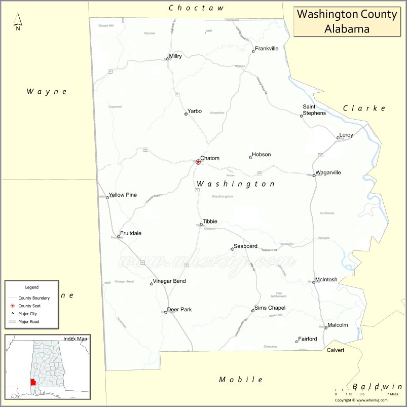
About Washington County Map, Alabama: The map showing the county boundary, county seat, major cities, highways, water bodies and neighbouring counties.
Most Viewed Links
Map of Washington County, Alabama
Washington County is a county located in the U.S. state of Alabama. It`s county seat is Chatom. As per 2020 census, the population of Washington County was 15147 and population density of Washington was 14square miles. According to the United States Census Bureau, the county has a total area of 1,080.21 sq mi (2,798 km2). Washington County was established on 1800.
Washington County Facts
| County Info | Facts |
|---|---|
| County | Washington County |
| County Seat | Chatom |
| State | Alabama |
| Country | United States |
| FIPS code | 129 |
| Established | 1800 |
| Area | 1,080.21 sq mi (2,798 km2) |
| Population | 15147 |
| Density | 14 |
| Formed / Origin | Adams and Pickering counties of Mississippi Territory |
Ctities and Towns in Washington
| City Name | Type | Population (2020) | Pop. Density | Area |
|---|---|---|---|---|
| Chatom | Town | 1,104 | 103.0/sq mi (39.8/km2) | 10.72 sq mi (27.8 km2) |
| McIntosh | Town | 206 | 206.0/sq mi (79.5/km2) | 1 sq mi (2.6 km2) |
| Millry | Town | 450 | 60.1/sq mi (23.2/km2) | 7.49 sq mi (19.4 km2) |
Places to Visit in Washington
Top places to visit in london includes Olympic National Park, Museum of Pop Culture,Space Needle, Chihuly Garden and Glass, Riverfront Park, Mount Saint Helens, North Cascades National Park, Mount Rainier National Park, San Juan Islands, Snoqualmie Falls, Spokane, Hoh Rain Forest Visitor Center, North Cascades, Columbia River Gorge National, Tacoma, Deception Pass, Port Townsend, Bainbridge Island, Gas Works Park, Mount Baker, Puget Sound, Golden Gardens Park, Manito Park, Stevens Pass, Okanogan-Wenatchee National, Northwest Trek Wildlife Park, Whidbey Island, Washington State Capitol Building, Snoqualmie, Orcas Island.
Highways in Washington
U.S. Highway 43, U.S. Highway 45, State Route 17, State Route 56.
Nearest Airports
Nearest airport of Washington is Washington National Airport.
- Autauga County Map
- Baldwin County Map
- Barbour County Map
- Bibb County Map
- Blount County Map
- Bullock County Map
- Butler County Map
- Calhoun County Map
- Chambers County Map
- Cherokee County Map
- Chilton County Map
- Choctaw County Map
- Clarke County Map
- Clay County Map
- Cleburne County Map
- Coffee County Map
- Colbert County Map
- Conecuh County Map
- Coosa County Map
- Covington County Map
- Crenshaw County Map
- Cullman County Map
- Dale County Map
- Dallas County Map
- DeKalb County Map
- Elmore County Map
- Escambia County Map
- Etowah County Map
- Fayette County Map
- Franklin County Map
- Geneva County Map
- Greene County Map
- Hale County Map
- Henry County Map
- Houston County Map
- Jackson County Map
- Jefferson County Map
- Lamar County Map
- Lauderdale County Map
- Lawrence County Map
- Lee County Map
- Limestone County Map
- Lowndes County Map
- Macon County Map
- Madison County Map
- Marengo County Map
- Marion County Map
- Marshall County Map
- Mobile County Map
- Monroe County Map
- Montgomery County Map
- Morgan County Map
- Perry County Map
- Pickens County Map
- Pike County Map
- Randolph County Map
- Russell County Map
- St Clair County Map
- Shelby County Map
- Sumter County Map
- Talladega County Map
- Tallapoosa County Map
- Tuscaloosa County Map
- Walker County Map
- Washington County Map
- Wilcox County Map
- Winston County Map
- Alabama Counties
- Alaska boroughs
- Arizona Counties
- Arkansas Counties
- California County Map
- Colorado Counties
- Connecticut Counties
- Delaware Counties
- Florida County Map
- Georgia County Map
- Hawaii Counties
- Idaho Counties
- Illinois Counties
- Indiana Counties
- Iowa Counties
- Kansas Counties
- Kentucky Counties
- Louisiana Counties
- Maine Counties
- Maryland Counties
- Massachusetts Counties
- Michigan County Map
- Minnesota Counties
- Mississippi Counties
- Missouri Counties
- Montana Counties
- Nebraska Counties
- New Hampshire Counties
- New Jersey Counties
- New Mexico Counties
- North Carolina Counties
- North Dakota Counties
- Oklahoma Counties
- Oregon Counties
- Pennsylvania Counties
- Rhode Island Counties
- South Carolina Counties
- South Dakota Counties
- Map of Tennessee
- Texas County Map
- Utah Counties
- Vermont Counties
- Virginia Counties
- Washington Counties
- West Virginia Counties
- Wisconsin Counties
- Wyoming Counties
- Nevada Counties
- New York Counties
- Ohio County Map