Map of Covington County - Covington County is a county located in the U.S. state of Alabama. Covington County Map showing cities, highways, important places and water bodies. Get Where is Covington County located in the map, major cities in Covington county, population, areas, and places of interest.
Covington County Map, Alabama
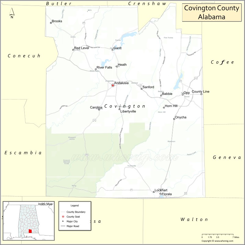
About Covington County Map, Alabama: The map showing the county boundary, county seat, major cities, highways, water bodies and neighbouring counties.
Most Viewed Links
Map of Covington County, Alabama
Covington County is a county located in the U.S. state of Alabama. It`s county seat is Andalusia. As per 2020 census, the population of Covington County was 37524 and population density of Covington was 36.4square miles. According to the United States Census Bureau, the county has a total area of 1,030.46 sq mi (2,669 km2). Covington County was established on 1821.
Covington County Facts
| Continent | North America |
| Country | United States |
| State | Alabama |
| County Seat | Andalusia |
| Largest City/Town | Andalusia |
| Established | December 17, 1821 |
| Total Area | 1,044 sq mi (2,704 sq km) |
| Land Area | 1,030 sq mi (2,668 sq km) |
| Water Area | 14 sq mi (36 sq km) |
| Population | 37,570 (Census 2020) |
| Population Density | 36 people per sq mi |
| Time Zone | Central Time Zone (CT) |
| Major Highways | US 29, US 84, AL 55, AL 54, AL 134, AL 137 |
| Major Rivers | Conecuh River, Yellow River, Shoal River |
| Neighboring Counties | Conecuh County, Butler County, Crenshaw County, Coffee County, Escambia County, Okaloosa County (FL), Walton County (FL) |
| Famous For | Conecuh National Forest, Andalusia, outdoor recreation, and southern Alabama heritage |
| Top Attractions | Conecuh National Forest, Frank Jackson State Park, Andalusia Downtown Square, Conecuh River, Three Notch Museum |
| Official Website | Official Website |
About Covington County, Alabama
Covington County is located in south-central Alabama along the Florida border and was established in 1821. The county seat and largest city is Andalusia. The county features extensive forests, rivers, and recreational areas, and serves as an important commercial and cultural center for the surrounding Wiregrass and Gulf Coastal Plain regions.
Cities and Towns in Covington County, Alabama
| City/Town | Population (Census 2020) | Latitude & Longitude |
|---|---|---|
| Andalusia (county seat) | 8,805 | 31.3085°N, 86.4830°W |
| Opp | 6,771 | 31.2827°N, 86.2555°W |
| Florala | 1,984 | 31.0057°N, 86.3280°W |
| Gantt | 222 | 31.4068°N, 86.4791°W |
| Heath | 338 | 31.3443°N, 86.3086°W |
| Horn Hill | 235 | 31.2437°N, 86.3225°W |
| River Falls | 526 | 31.3629°N, 86.5405°W |
| Red Level | 445 | 31.4098°N, 86.7005°W |
| Libertyville (CDP) | 113 | 31.1799°N, 86.5952°W |
| Lockhart (CDP) | 456 | 31.0107°N, 86.3491°W |
Best Golf Courses in Covington County, Alabama
| Golf Course | Location | Latitude & Longitude |
|---|---|---|
| Evans Barnes Golf Course | Andalusia | 31.3125°N, 86.4867°W |
| Andalusia Country Club | Andalusia | 31.2874°N, 86.4943°W |
| Opp Country Club | Opp | 31.2756°N, 86.2609°W |
| Dogwood Lakes Golf Course | Bonifay Area (near county line) | 31.0284°N, 85.7031°W |
What are Major Roads and Highways in Covington County
Major highways connect the county to nearby regions and cities.
- US Highway 29 - north-south route connecting Andalusia with Brewton and Montgomery regions
- US Highway 84 - major east-west corridor connecting Opp, Andalusia, and Enterprise
- Alabama State Route 55 - connects Andalusia with Florala and Interstate 65 areas
- Alabama State Route 54 - serves southern portions of the county
- Alabama State Route 134 - connects Opp with Coffee and Geneva counties
- Alabama State Route 137 - links Andalusia with Florida communities
Neighboring Counties of Covington County
- Butler County (north)
- Crenshaw County (northeast)
- Coffee County (east)
- Escambia County (southwest)
- Conecuh County (northwest)
- Okaloosa County, Florida (south)
- Walton County, Florida (southeast)
What are Top Attractions in Covington County, Alabama
The county offers a mix of natural and cultural attractions.
| Main Sight Name | City | Famous For |
|---|---|---|
| Frank Jackson State Park | Opp | Lake recreation, camping, and fishing |
| Conecuh National Forest | Southern County | Hiking, wildlife viewing, and outdoor recreation |
| Three Notch Museum | Andalusia | Local history and railroad heritage |
| Andalusia Downtown Square | Andalusia | Historic architecture and shopping |
| Lake Jackson | Opp | Boating, fishing, and water recreation |
| Conecuh River | Countywide | Paddling, fishing, and scenic landscapes |
| Florala State Line Lake | Florala | Large natural lake on the Alabama-Florida border |
| Covington County Courthouse | Andalusia | Historic county landmark |
| Point A Lake | Andalusia Area | Fishing and outdoor recreation |
| Gantt Lake | Gantt | Water sports and lakeside scenery |
| Blue Springs Wildlife Area | Red Level Area | Nature observation and outdoor activities |
| Florala Historic District | Florala | Historic homes and community heritage |
Distance from Covington County to Nearby Cities
The following distances are measured by road (driving).
- Andalusia to Opp (Covington County), Alabama - 17 mi (27 km)
- Andalusia to Florala (Covington County), Alabama - 31 mi (50 km)
- Andalusia to River Falls (Covington County), Alabama - 6 mi (10 km)
- Andalusia to Elba (Coffee County), Alabama - 33 mi (53 km)
- Andalusia to Evergreen (Conecuh County), Alabama - 48 mi (77 km)
- Andalusia to Brewton (Escambia County), Alabama - 38 mi (61 km)
- Andalusia to Greenville (Butler County), Alabama - 54 mi (87 km)
- Andalusia to Enterprise (Coffee County), Alabama - 32 mi (52 km)
- Andalusia to Dothan (Houston County), Alabama - 79 mi (127 km)
- Andalusia to Montgomery (Montgomery County), Alabama - 92 mi (148 km)
- Andalusia to Pensacola, Florida - 89 mi (143 km)
- Andalusia to Destin, Florida - 82 mi (132 km)
- Andalusia to Mobile (Mobile County), Alabama - 108 mi (174 km)
Nearest Airports
Covington Nearest airport of Covington is South Alabama Regional Airport.
References
- QuickFacts - U.S. Census Bureau
- United States Census Bureau
- United States Geological Survey (USGS)
- National Geodetic Survey
- Official County Website
- Autauga County Map
- Baldwin County Map
- Barbour County Map
- Bibb County Map
- Blount County Map
- Bullock County Map
- Butler County Map
- Calhoun County Map
- Chambers County Map
- Cherokee County Map
- Chilton County Map
- Choctaw County Map
- Clarke County Map
- Clay County Map
- Cleburne County Map
- Coffee County Map
- Colbert County Map
- Conecuh County Map
- Coosa County Map
- Covington County Map
- Crenshaw County Map
- Cullman County Map
- Dale County Map
- Dallas County Map
- DeKalb County Map
- Elmore County Map
- Escambia County Map
- Etowah County Map
- Fayette County Map
- Franklin County Map
- Geneva County Map
- Greene County Map
- Hale County Map
- Henry County Map
- Houston County Map
- Jackson County Map
- Jefferson County Map
- Lamar County Map
- Lauderdale County Map
- Lawrence County Map
- Lee County Map
- Limestone County Map
- Lowndes County Map
- Macon County Map
- Madison County Map
- Marengo County Map
- Marion County Map
- Marshall County Map
- Mobile County Map
- Monroe County Map
- Montgomery County Map
- Morgan County Map
- Perry County Map
- Pickens County Map
- Pike County Map
- Randolph County Map
- Russell County Map
- St Clair County Map
- Shelby County Map
- Sumter County Map
- Talladega County Map
- Tallapoosa County Map
- Tuscaloosa County Map
- Walker County Map
- Washington County Map
- Wilcox County Map
- Winston County Map
- Alabama Counties
- Alaska boroughs
- Arizona Counties
- Arkansas Counties
- California County Map
- Colorado Counties
- Connecticut Counties
- Delaware Counties
- Florida County Map
- Georgia County Map
- Hawaii Counties
- Idaho Counties
- Illinois Counties
- Indiana Counties
- Iowa Counties
- Kansas Counties
- Kentucky Counties
- Louisiana Counties
- Maine Counties
- Maryland Counties
- Massachusetts Counties
- Michigan County Map
- Minnesota Counties
- Mississippi Counties
- Missouri Counties
- Montana Counties
- Nebraska Counties
- Nevada Counties
- New York Counties
- New Hampshire Counties
- New Jersey Counties
- New Mexico Counties
- North Carolina Counties
- North Dakota Counties
- Ohio County Map
- Oklahoma Counties
- Oregon Counties
- Pennsylvania Counties
- Rhode Island Counties
- South Carolina Counties
- South Dakota Counties
- Map of Tennessee
- Texas County Map
- Utah Counties
- Vermont Counties
- Virginia Counties
- Washington Counties
- West Virginia Counties
- Wisconsin Counties
- Wyoming Counties