Map of Pickens County - Pickens County is a county located in the U.S. state of Alabama. Pickens County Map showing cities, highways, important places and water bodies. Get Where is Pickens County located in the map, major cities in Pickens county, population, areas, and places of interest.
Pickens County Map, Alabama
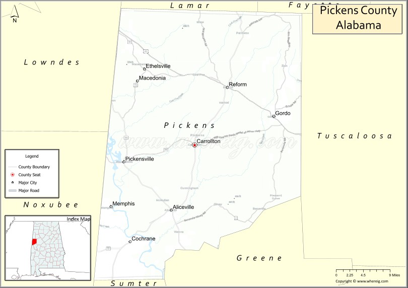
About Pickens County Map, Alabama: The map showing the county boundary, county seat, major cities, highways, water bodies and neighbouring counties.
Most Viewed Links
Map of Pickens County, Alabama
Pickens County is a county located in the U.S. state of Alabama. It`s county seat is Carrollton. As per 2020 census, the population of Pickens County was 18801 and population density of Pickens was 21.3square miles. According to the United States Census Bureau, the county has a total area of 881.41 sq mi (2,283 km2). Pickens County was established on 1820.
Pickens County Facts
| Continent | North America |
| Country | United States |
| State | Alabama |
| County Seat | Carrollton |
| Largest City/Town | Aliceville |
| Established | December 19, 1820 |
| Total Area | 890 sq mi (2,305 sq km) |
| Land Area | 881 sq mi (2,282 sq km) |
| Water Area | 9 sq mi (23 sq km) |
| Population | 19,123 (Census 2020) |
| Population Density | 22 people per sq mi |
| Time Zone | Central Time Zone (CT) |
| Major Highways | US 82, AL 14, AL 17, AL 32, AL 86 |
| Major Rivers | Tombigbee River, Sipsey River, Lubbub Creek |
| Neighboring Counties | Lamar County, Fayette County, Tuscaloosa County, Greene County, Lowndes County (MS), Noxubee County (MS) |
| Famous For | Aliceville POW Camp Museum, Tombigbee River, agriculture, and Alabama-Mississippi border heritage |
| Top Attractions | Aliceville Museum, Pickensville Marina, Carrollton Historic District, Tombigbee River, and Lake Lurleen access areas |
| Official Website | Official Website |
About Pickens County, Alabama
Pickens County is located in western Alabama along the Mississippi state line and was established in 1820. The county seat is Carrollton, while Aliceville is the largest city. The county is characterized by rolling farmland, forests, and river corridors associated with the Tombigbee River basin. Agriculture, manufacturing, transportation, and outdoor recreation remain important parts of the local economy and culture.
Cities and Towns in Pickens County, Alabama
| City/Town | Population (Census 2020) | Latitude & Longitude |
|---|---|---|
| Carrollton (county seat) | 923 | 33.2618°N, 88.0959°W |
| Aliceville | 2,346 | 33.1298°N, 88.1514°W |
| Gordo | 1,628 | 33.3201°N, 87.9028°W |
| Pickensville | 553 | 33.2243°N, 88.2748°W |
| Reform | 1,520 | 33.3782°N, 88.0159°W |
| Memphis (CDP) | 109 | 33.0891°N, 88.0436°W |
| McShan (CDP) | 239 | 33.2609°N, 88.0096°W |
| Benevola (CDP) | 176 | 33.4317°N, 88.0631°W |
| Palmetto (CDP) | 147 | 33.1374°N, 88.0244°W |
| Cochrane (CDP) | 94 | 33.0785°N, 88.2564°W |
Best Golf Courses in Pickens County, Alabama
| Golf Course | Location | Latitude & Longitude |
|---|---|---|
| Kirkwood National Golf Club | Reform | 33.3578°N, 88.0114°W |
| Aliceville Country Club | Aliceville | 33.1335°N, 88.1476°W |
| Pickens County Golf Club | Carrollton | 33.2595°N, 88.0888°W |
What are Major Roads and Highways in Pickens County
Major highways connect the county to nearby regions and cities.
- US Highway 82 - major east-west route connecting Reform, Gordo, Tuscaloosa, and Mississippi
- Alabama State Route 17 - north-south highway linking Carrollton, Aliceville, and Sumter County
- Alabama State Route 14 - connects Pickensville and western communities with Greene County
- Alabama State Route 32 - serves southern portions of the county
- Alabama State Route 86 - provides access to rural communities and agricultural areas
Neighboring Counties of Pickens County
- Lamar County (north)
- Fayette County (northeast)
- Tuscaloosa County (east)
- Greene County (south)
- Lowndes County, Mississippi (west)
- Noxubee County, Mississippi (southwest)
What are Top Attractions in Pickens County, Alabama
The county offers a mix of natural and cultural attractions.
| Main Sight Name | City | Famous For |
|---|---|---|
| Aliceville Museum and Cultural Center | Aliceville | World War II POW Camp Aliceville exhibits |
| Camp Aliceville POW Museum | Aliceville | History of German prisoners held during World War II |
| Carrollton Historic District | Carrollton | Historic courthouse and downtown architecture |
| Pickens County Courthouse | Carrollton | Historic county landmark built in the 1870s |
| Tombigbee River | Countywide | Fishing, boating, and scenic river views |
| Pickensville Marina | Pickensville | River access and recreational boating |
| Kirkwood National Golf Club | Reform | Championship golf course and resort-style play |
| Gordo City Park | Gordo | Community recreation and outdoor activities |
| Lubbub Creek Corridor | Countywide | Wildlife habitat and natural scenery |
| Reform Historic District | Reform | Historic buildings and local heritage |
| Sipsey River Area | Southern County | Fishing, paddling, and wildlife viewing |
| Pickensville Riverfront Area | Pickensville | Waterfront recreation and scenic overlooks |
Distance from Pickens County to Nearby Cities
The following distances are measured by road (driving).
- Carrollton to Aliceville (Pickens County), Alabama - 10 mi (16 km)
- Carrollton to Reform (Pickens County), Alabama - 13 mi (21 km)
- Carrollton to Gordo (Pickens County), Alabama - 16 mi (26 km)
- Carrollton to Pickensville (Pickens County), Alabama - 13 mi (21 km)
- Carrollton to Fayette (Fayette County), Alabama - 31 mi (50 km)
- Carrollton to Vernon (Lamar County), Alabama - 27 mi (43 km)
- Carrollton to Tuscaloosa (Tuscaloosa County), Alabama - 37 mi (60 km)
- Carrollton to Eutaw (Greene County), Alabama - 34 mi (55 km)
- Carrollton to Columbus, Mississippi - 31 mi (50 km)
- Carrollton to Starkville, Mississippi - 42 mi (68 km)
- Carrollton to West Point, Mississippi - 38 mi (61 km)
- Carrollton to Birmingham (Jefferson County), Alabama - 85 mi (137 km)
- Carrollton to Meridian, Mississippi - 96 mi (154 km)
- Carrollton to Huntsville (Madison County), Alabama - 152 mi (245 km)
Nearest Airports
Nearest airport of Pickens is North Pickens County Airport.
References
- QuickFacts - U.S. Census Bureau
- United States Census Bureau
- United States Geological Survey (USGS)
- National Geodetic Survey
- Official County Website
- Autauga County Map
- Baldwin County Map
- Barbour County Map
- Bibb County Map
- Blount County Map
- Bullock County Map
- Butler County Map
- Calhoun County Map
- Chambers County Map
- Cherokee County Map
- Chilton County Map
- Choctaw County Map
- Clarke County Map
- Clay County Map
- Cleburne County Map
- Coffee County Map
- Colbert County Map
- Conecuh County Map
- Coosa County Map
- Covington County Map
- Crenshaw County Map
- Cullman County Map
- Dale County Map
- Dallas County Map
- DeKalb County Map
- Elmore County Map
- Escambia County Map
- Etowah County Map
- Fayette County Map
- Franklin County Map
- Geneva County Map
- Greene County Map
- Hale County Map
- Henry County Map
- Houston County Map
- Jackson County Map
- Jefferson County Map
- Lamar County Map
- Lauderdale County Map
- Lawrence County Map
- Lee County Map
- Limestone County Map
- Lowndes County Map
- Macon County Map
- Madison County Map
- Marengo County Map
- Marion County Map
- Marshall County Map
- Mobile County Map
- Monroe County Map
- Montgomery County Map
- Morgan County Map
- Perry County Map
- Pickens County Map
- Pike County Map
- Randolph County Map
- Russell County Map
- St Clair County Map
- Shelby County Map
- Sumter County Map
- Talladega County Map
- Tallapoosa County Map
- Tuscaloosa County Map
- Walker County Map
- Washington County Map
- Wilcox County Map
- Winston County Map
- Alabama Counties
- Alaska boroughs
- Arizona Counties
- Arkansas Counties
- California County Map
- Colorado Counties
- Connecticut Counties
- Delaware Counties
- Florida County Map
- Georgia County Map
- Hawaii Counties
- Idaho Counties
- Illinois Counties
- Indiana Counties
- Iowa Counties
- Kansas Counties
- Kentucky Counties
- Louisiana Counties
- Maine Counties
- Maryland Counties
- Massachusetts Counties
- Michigan County Map
- Minnesota Counties
- Mississippi Counties
- Missouri Counties
- Montana Counties
- Nebraska Counties
- Nevada Counties
- New York Counties
- New Hampshire Counties
- New Jersey Counties
- New Mexico Counties
- North Carolina Counties
- North Dakota Counties
- Ohio County Map
- Oklahoma Counties
- Oregon Counties
- Pennsylvania Counties
- Rhode Island Counties
- South Carolina Counties
- South Dakota Counties
- Map of Tennessee
- Texas County Map
- Utah Counties
- Vermont Counties
- Virginia Counties
- Washington Counties
- West Virginia Counties
- Wisconsin Counties
- Wyoming Counties