Map of Bullock County - Bullock County is a county located in the U.S. state of Alabama. Bullock County Map showing cities, highways, important places and water bodies. Get Where is Bullock County located in the map, major cities in Bullock county, population, areas, and places of interest.
Bullock County Map, Alabama
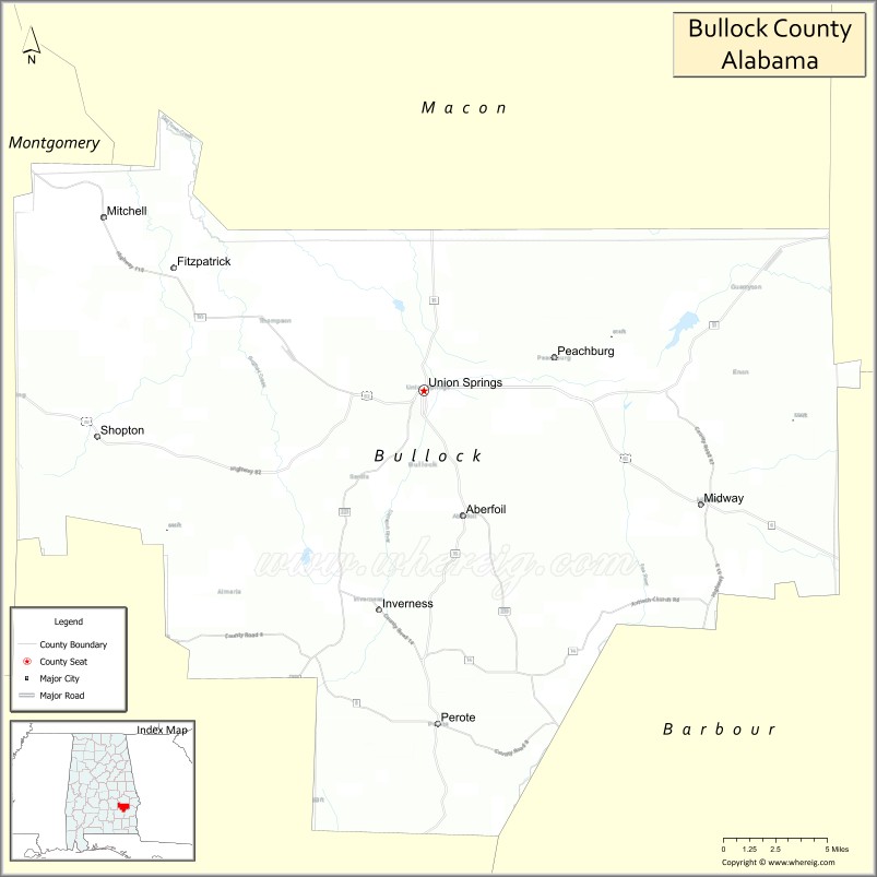
About Bullock County Map, Alabama: The map showing the county boundary, county seat, major cities, highways, water bodies and neighbouring counties.
Most Viewed Links
Map of Bullock County, Alabama
Bullock County is a county located in the U.S. state of Alabama. It`s county seat is Union Springs. As per 2020 census, the population of Bullock County was 10320 and population density of Bullock was 16.6square miles. According to the United States Census Bureau, the county has a total area of 622.80 sq mi (1,613 km2). Bullock County was established on 1866.
Bullock County Facts
| Continent | North America |
| Country | United States |
| State | Alabama |
| County Seat | Union Springs |
| Largest City/Town | Union Springs |
| Established | December 5, 1866 |
| Total Area | 625 sq mi (1,619 sq km) |
| Land Area | 623 sq mi (1,614 sq km) |
| Water Area | 2 sq mi (5 sq km) |
| Population | 10,357 (Census 2020) |
| Population Density | 17 people per sq mi |
| Time Zone | Central Time Zone (CT) |
| Major Highways | US 82, AL 51, AL 110, AL 223 |
| Major Rivers | Conecuh River Tributaries, Pea River Tributaries |
| Neighboring Counties | Macon County, Russell County, Barbour County, Pike County, Montgomery County |
| Famous For | Field trial bird dog competitions, hunting preserves, Union Springs, and Black Belt heritage |
| Top Attractions | Bird Dog Field Trial Grounds, Bullock County Courthouse, Union Springs Historic District, Wehle Wildlife Preserve |
| Official Website | Official Website |
About Bullock County, Alabama
Bullock County is located in the southeastern part of Alabama and was established in 1866. The county seat and largest city is Union Springs. The county lies within Alabama's Black Belt region and is known for its rolling farmland, hunting preserves, wildlife habitats, and long tradition of field trial competitions for bird dogs.
Cities and Towns in Bullock County, Alabama
| City/Town | Population (Census 2020) | Latitude & Longitude |
|---|---|---|
| Union Springs (county seat) | 3,346 | 32.1443°N, 85.7144°W |
| Midway | 421 | 32.0740°N, 85.5205°W |
| Fitzpatrick (CDP) | 83 | 32.1760°N, 85.8974°W |
Best Golf Courses in Bullock County, Alabama
| Golf Course | Location | Latitude & Longitude |
|---|---|---|
| Dogwood Trace Golf Course | Union Springs | 32.1466°N, 85.7345°W |
What are Major Roads and Highways in Bullock County
Major highways connect the county to nearby regions and cities.
- US Highway 82 - east-west route connecting Union Springs with Montgomery and Eufaula
- Alabama State Route 51 - north-south route connecting Union Springs and Midway
- Alabama State Route 110 - connects Union Springs with Bullock and Barbour county communities
- Alabama State Route 223 - links Union Springs with Pike County and surrounding rural areas
Neighboring Counties of Bullock County
- Macon County (north)
- Russell County (northeast)
- Barbour County (east)
- Pike County (south)
- Montgomery County (west)
What are Top Attractions in Bullock County, Alabama
The county offers a mix of natural and cultural attractions.
| Main Sight Name | City | Famous For |
|---|---|---|
| Bird Dog Field Trial Grounds | Union Springs | Nationally known bird dog competitions |
| Union Springs Historic District | Union Springs | Historic architecture and downtown heritage |
| Bullock County Courthouse | Union Springs | Historic county landmark |
| Wehle Wildlife Preserve | Midway Area | Wildlife habitat and conservation lands |
| Chunnennuggee Ridge | Union Springs Area | Scenic Black Belt landscape |
| Midway Historic Community | Midway | Small-town Alabama heritage |
| Pea River Tributary Recreation Areas | Countywide | Fishing and outdoor recreation |
| Bullock County Hunting Preserves | Countywide | Deer, turkey, and upland game hunting |
| Union Springs Sports Complex | Union Springs | Community recreation and events |
| Historic Churches of Bullock County | Countywide | Historic religious landmarks |
Distance from Bullock County to Nearby Cities
The following distances are measured by road (driving).
- Union Springs to Midway (Bullock County), Alabama - 13 mi (21 km)
- Union Springs to Eufaula (Barbour County), Alabama - 41 mi (66 km)
- Union Springs to Troy (Pike County), Alabama - 32 mi (51 km)
- Union Springs to Tuskegee (Macon County), Alabama - 29 mi (47 km)
- Union Springs to Auburn (Lee County), Alabama - 37 mi (60 km)
- Union Springs to Opelika (Lee County), Alabama - 42 mi (68 km)
- Union Springs to Phenix City (Russell County), Alabama - 54 mi (87 km)
- Union Springs to Montgomery (Montgomery County), Alabama - 47 mi (76 km)
- Union Springs to Dothan (Houston County), Alabama - 86 mi (138 km)
- Union Springs to Enterprise (Coffee County), Alabama - 72 mi (116 km)
- Union Springs to Clanton (Chilton County), Alabama - 88 mi (142 km)
- Union Springs to Birmingham (Jefferson County), Alabama - 123 mi (198 km)
- Union Springs to Columbus, Georgia - 60 mi (97 km)
Nearest Airports
Nearest airport of Bullock is Dothan Regional Airport (DHN / KDHN).
References
- QuickFacts - U.S. Census Bureau
- United States Census Bureau
- United States Geological Survey (USGS)
- National Geodetic Survey
- Official County Website
- Autauga County Map
- Baldwin County Map
- Barbour County Map
- Bibb County Map
- Blount County Map
- Bullock County Map
- Butler County Map
- Calhoun County Map
- Chambers County Map
- Cherokee County Map
- Chilton County Map
- Choctaw County Map
- Clarke County Map
- Clay County Map
- Cleburne County Map
- Coffee County Map
- Colbert County Map
- Conecuh County Map
- Coosa County Map
- Covington County Map
- Crenshaw County Map
- Cullman County Map
- Dale County Map
- Dallas County Map
- DeKalb County Map
- Elmore County Map
- Escambia County Map
- Etowah County Map
- Fayette County Map
- Franklin County Map
- Geneva County Map
- Greene County Map
- Hale County Map
- Henry County Map
- Houston County Map
- Jackson County Map
- Jefferson County Map
- Lamar County Map
- Lauderdale County Map
- Lawrence County Map
- Lee County Map
- Limestone County Map
- Lowndes County Map
- Macon County Map
- Madison County Map
- Marengo County Map
- Marion County Map
- Marshall County Map
- Mobile County Map
- Monroe County Map
- Montgomery County Map
- Morgan County Map
- Perry County Map
- Pickens County Map
- Pike County Map
- Randolph County Map
- Russell County Map
- St Clair County Map
- Shelby County Map
- Sumter County Map
- Talladega County Map
- Tallapoosa County Map
- Tuscaloosa County Map
- Walker County Map
- Washington County Map
- Wilcox County Map
- Winston County Map
- Alabama Counties
- Alaska boroughs
- Arizona Counties
- Arkansas Counties
- California County Map
- Colorado Counties
- Connecticut Counties
- Delaware Counties
- Florida County Map
- Georgia County Map
- Hawaii Counties
- Idaho Counties
- Illinois Counties
- Indiana Counties
- Iowa Counties
- Kansas Counties
- Kentucky Counties
- Louisiana Counties
- Maine Counties
- Maryland Counties
- Massachusetts Counties
- Michigan County Map
- Minnesota Counties
- Mississippi Counties
- Missouri Counties
- Montana Counties
- Nebraska Counties
- Nevada Counties
- New York Counties
- New Hampshire Counties
- New Jersey Counties
- New Mexico Counties
- North Carolina Counties
- North Dakota Counties
- Ohio County Map
- Oklahoma Counties
- Oregon Counties
- Pennsylvania Counties
- Rhode Island Counties
- South Carolina Counties
- South Dakota Counties
- Map of Tennessee
- Texas County Map
- Utah Counties
- Vermont Counties
- Virginia Counties
- Washington Counties
- West Virginia Counties
- Wisconsin Counties
- Wyoming Counties