Map of Lee County - Lee County is a county located in the U.S. state of Alabama. Lee County Map showing cities, highways, important places and water bodies. Get Where is Lee County located in the map, major cities in Lee county, population, areas, and places of interest.
Lee County Map, Alabama
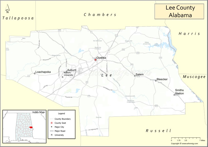
About Lee County Map, Alabama: The map showing the county boundary, county seat, major cities, highways, water bodies and neighbouring counties.
Most Viewed Links
Map of Lee County, Alabama
Lee County is a county located in the U.S. state of Alabama. It`s county seat is Opelika. As per 2020 census, the population of Lee County was 177218 and population density of Lee was 291.7square miles. According to the United States Census Bureau, the county has a total area of 607.54 sq mi (1,574 km2). Lee County was established on 1866.
Lee County Facts
| Continent | North America |
| Country | United States |
| State | Alabama |
| County Seat | Opelika |
| Largest City/Town | Auburn |
| Established | December 5, 1866 |
| Total Area | 616 sq mi (1,595 sq km) |
| Land Area | 608 sq mi (1,575 sq km) |
| Water Area | 8 sq mi (21 sq km) |
| Population | 174,241 (Census 2020) |
| Population Density | 287 people per sq mi |
| Time Zone | Central Time Zone (CT) |
| Major Highways | Interstate 85, US 29, US 280, US 431, AL 14, AL 51 |
| Major Rivers | Chattahoochee River, Tallapoosa River |
| Neighboring Counties | Chambers County, Tallapoosa County, Macon County, Russell County |
| Famous For | Auburn University, college athletics, Chewacla State Park, and the Auburn-Opelika metropolitan area |
| Top Attractions | Auburn University, Chewacla State Park, Jule Collins Smith Museum of Fine Art, Toomer's Corner, and Kiesel Park |
| Official Website | Official Website |
About Lee County, Alabama
Lee County is located in east-central Alabama along the Georgia border and was established in 1866. The county seat is Opelika, while Auburn is the largest city. The county is best known as the home of Auburn University and is one of Alabama's fastest-growing counties. Lee County combines higher education, technology, healthcare, manufacturing, and outdoor recreation, making it an important economic center in eastern Alabama.
Cities and Towns in Lee County, Alabama
| City/Town | Population (Census 2020) | Latitude & Longitude |
|---|---|---|
| Opelika (county seat) | 30,995 | 32.6454°N, 85.3783°W |
| Auburn | 76,143 | 32.6099°N, 85.4808°W |
| Loachapoka | 159 | 32.6040°N, 85.5958°W |
| Smiths Station (partly in Lee County) | 5,728 | 32.5401°N, 85.0988°W |
| Phenix City (partly in Lee County) | 38,817 | 32.4709°N, 85.0008°W |
| Beauregard (CDP) | 10,160 | 32.4308°N, 85.7147°W |
| Waverly (CDP) | 148 | 32.7337°N, 85.5636°W |
| The Bottle (CDP) | 209 | 32.7055°N, 85.4105°W |
| Marvyn (CDP) | 1,450 | 32.2797°N, 85.2846°W |
Best Golf Courses in Lee County, Alabama
| Golf Course | Location | Latitude & Longitude |
|---|---|---|
| Grand National Golf Complex - Lake Course | Opelika | 32.6558°N, 85.2838°W |
| Grand National Golf Complex - Links Course | Opelika | 32.6558°N, 85.2838°W |
| Grand National Golf Complex - Short Course | Opelika | 32.6558°N, 85.2838°W |
| Auburn University Club | Auburn | 32.5334°N, 85.5088°W |
| Moore's Mill Club | Auburn | 32.6579°N, 85.4248°W |
| Indian Pines Golf Course | Auburn | 32.5702°N, 85.4476°W |
| Saugahatchee Country Club | Opelika | 32.6765°N, 85.3799°W |
| Point University Golf Club | Opelika | 32.6908°N, 85.3687°W |
What are Major Roads and Highways in Lee County
Major highways connect the county to nearby regions and cities.
- Interstate 85 - major interstate connecting Auburn and Opelika with Montgomery and Atlanta
- US Highway 29 - historic route through Auburn and Opelika
- US Highway 280 - major corridor linking Opelika with Birmingham and Columbus, Georgia
- US Highway 431 - north-south route connecting Opelika with Dothan and Gadsden
- Alabama State Route 14 - east-west route through the county
- Alabama State Route 51 - connects Auburn with rural communities in southern Lee County
Neighboring Counties of Lee County
- Chambers County (north)
- Tallapoosa County (northwest)
- Macon County (southwest)
- Russell County (southeast)
What are Top Attractions in Lee County, Alabama
The county offers a mix of natural and cultural attractions.
| Main Sight Name | City | Famous For |
|---|---|---|
| Auburn University | Auburn | Major public university and SEC athletics |
| Jordan-Hare Stadium | Auburn | Home of Auburn Tigers football |
| Toomer's Corner | Auburn | Historic downtown landmark and celebration site |
| Chewacla State Park | Auburn | Waterfalls, hiking trails, camping, and mountain biking |
| Jule Collins Smith Museum of Fine Art | Auburn | Art collections and exhibitions |
| Kiesel Park | Auburn | Large public park and walking trails |
| Donald E. Davis Arboretum | Auburn | Native Alabama plant collections |
| Grand National Golf Complex | Opelika | Robert Trent Jones Golf Trail destination |
| Museum of East Alabama | Opelika | Regional history exhibits |
| Historic Downtown Opelika | Opelika | Historic architecture, dining, and shopping |
| Kreher Preserve and Nature Center | Auburn | Environmental education and nature trails |
| Lake Harding | Eastern Lee County | Boating, fishing, and waterfront recreation |
Distance from Lee County to Nearby Cities
The following distances are measured by road (driving).
- Opelika to Auburn (Lee County), Alabama - 8 mi (13 km)
- Opelika to Loachapoka (Lee County), Alabama - 15 mi (24 km)
- Opelika to Beauregard (Lee County), Alabama - 19 mi (31 km)
- Opelika to Phenix City (Russell County), Alabama - 29 mi (47 km)
- Opelika to Valley (Chambers County), Alabama - 23 mi (37 km)
- Opelika to Alexander City (Tallapoosa County), Alabama - 35 mi (56 km)
- Opelika to Tuskegee (Macon County), Alabama - 21 mi (34 km)
- Opelika to Montgomery (Montgomery County), Alabama - 58 mi (93 km)
- Opelika to Columbus, Georgia - 35 mi (56 km)
- Opelika to LaGrange, Georgia - 31 mi (50 km)
- Opelika to Birmingham (Jefferson County), Alabama - 115 mi (185 km)
- Opelika to Atlanta, Georgia - 105 mi (169 km)
- Opelika to Dothan (Houston County), Alabama - 89 mi (143 km)
- Opelika to Huntsville (Madison County), Alabama - 190 mi (306 km)
Nearest Airports
Nearest airport of Lee is Dothan Regional Airport (DHN / KDHN).
References
- QuickFacts - U.S. Census Bureau
- United States Census Bureau
- United States Geological Survey (USGS)
- National Geodetic Survey
- Official County Website
- Autauga County Map
- Baldwin County Map
- Barbour County Map
- Bibb County Map
- Blount County Map
- Bullock County Map
- Butler County Map
- Calhoun County Map
- Chambers County Map
- Cherokee County Map
- Chilton County Map
- Choctaw County Map
- Clarke County Map
- Clay County Map
- Cleburne County Map
- Coffee County Map
- Colbert County Map
- Conecuh County Map
- Coosa County Map
- Covington County Map
- Crenshaw County Map
- Cullman County Map
- Dale County Map
- Dallas County Map
- DeKalb County Map
- Elmore County Map
- Escambia County Map
- Etowah County Map
- Fayette County Map
- Franklin County Map
- Geneva County Map
- Greene County Map
- Hale County Map
- Henry County Map
- Houston County Map
- Jackson County Map
- Jefferson County Map
- Lamar County Map
- Lauderdale County Map
- Lawrence County Map
- Lee County Map
- Limestone County Map
- Lowndes County Map
- Macon County Map
- Madison County Map
- Marengo County Map
- Marion County Map
- Marshall County Map
- Mobile County Map
- Monroe County Map
- Montgomery County Map
- Morgan County Map
- Perry County Map
- Pickens County Map
- Pike County Map
- Randolph County Map
- Russell County Map
- St Clair County Map
- Shelby County Map
- Sumter County Map
- Talladega County Map
- Tallapoosa County Map
- Tuscaloosa County Map
- Walker County Map
- Washington County Map
- Wilcox County Map
- Winston County Map
- Alabama Counties
- Alaska boroughs
- Arizona Counties
- Arkansas Counties
- California County Map
- Colorado Counties
- Connecticut Counties
- Delaware Counties
- Florida County Map
- Georgia County Map
- Hawaii Counties
- Idaho Counties
- Illinois Counties
- Indiana Counties
- Iowa Counties
- Kansas Counties
- Kentucky Counties
- Louisiana Counties
- Maine Counties
- Maryland Counties
- Massachusetts Counties
- Michigan County Map
- Minnesota Counties
- Mississippi Counties
- Missouri Counties
- Montana Counties
- Nebraska Counties
- Nevada Counties
- New York Counties
- New Hampshire Counties
- New Jersey Counties
- New Mexico Counties
- North Carolina Counties
- North Dakota Counties
- Ohio County Map
- Oklahoma Counties
- Oregon Counties
- Pennsylvania Counties
- Rhode Island Counties
- South Carolina Counties
- South Dakota Counties
- Map of Tennessee
- Texas County Map
- Utah Counties
- Vermont Counties
- Virginia Counties
- Washington Counties
- West Virginia Counties
- Wisconsin Counties
- Wyoming Counties