Map of Crenshaw County - Crenshaw County is a county located in the U.S. state of Alabama. Crenshaw County Map showing cities, highways, important places and water bodies. Get Where is Crenshaw County located in the map, major cities in Crenshaw county, population, areas, and places of interest.
Crenshaw County Map, Alabama
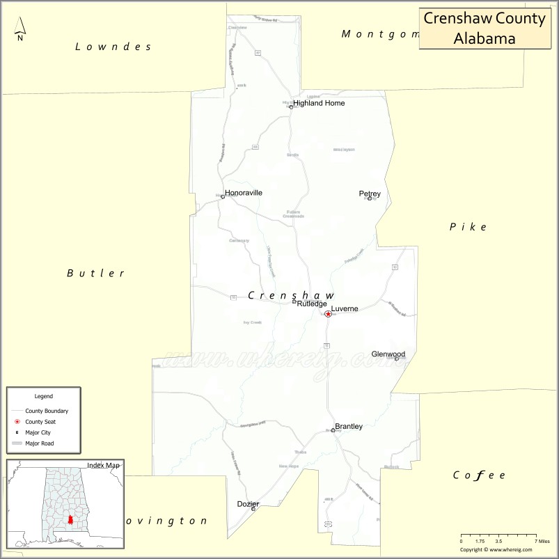
About Crenshaw County Map, Alabama: The map showing the county boundary, county seat, major cities, highways, water bodies and neighbouring counties.
Most Viewed Links
Map of Crenshaw County, Alabama
Crenshaw County is a county located in the U.S. state of Alabama. It`s county seat is Luverne. As per 2020 census, the population of Crenshaw County was 13083 and population density of Crenshaw was 21.5square miles. According to the United States Census Bureau, the county has a total area of 608.84 sq mi (1,577 km2). Crenshaw County was established on 1866.
Crenshaw County Facts
| Continent | North America |
| Country | United States |
| State | Alabama |
| County Seat | Luverne |
| Largest City/Town | Luverne |
| Established | November 30, 1866 |
| Total Area | 611 sq mi (1,582 sq km) |
| Land Area | 609 sq mi (1,577 sq km) |
| Water Area | 2 sq mi (5 sq km) |
| Population | 13,194 (Census 2020) |
| Population Density | 22 people per sq mi |
| Time Zone | Central Time Zone (CT) |
| Major Highways | US 29, US 331, AL 10, AL 97 |
| Major Rivers | Patsaliga Creek, Conecuh River |
| Neighboring Counties | Butler County, Pike County, Coffee County, Covington County, Conecuh County, Lowndes County |
| Famous For | Rural landscapes, peanut farming, forestry, and southern Alabama heritage |
| Top Attractions | Turnipseed Camp, Luverne Historic District, Patsaliga Creek, Crenshaw County Lake, Fuller's Crossroads |
| Official Website | Official Website |
About Crenshaw County, Alabama
Crenshaw County is located in south-central Alabama and was established in 1866. The county seat and largest city is Luverne. The county is characterized by rolling farmland, forests, and small communities, with agriculture and timber continuing to play important roles in the local economy.
Cities and Towns in Crenshaw County, Alabama
| City/Town | Population (Census 2020) | Latitude & Longitude |
|---|---|---|
| Luverne (county seat) | 2,765 | 31.7160°N, 86.2636°W |
| Brantley | 764 | 31.5826°N, 86.2563°W |
| Dozier | 329 | 31.4957°N, 86.3669°W |
| Glenwood | 168 | 31.6544°N, 86.1922°W |
| Highland Home | 1,015 | 31.9534°N, 86.3138°W |
| Petrey | 46 | 31.8475°N, 86.2094°W |
| Rutledge | 335 | 31.7252°N, 86.3074°W |
| Honoraville (CDP) | 745 | 31.8463°N, 86.3882°W |
Best Golf Courses in Crenshaw County, Alabama
| Golf Course | Location | Latitude & Longitude |
|---|---|---|
| Luverne Country Club | Luverne | 31.7236°N, 86.2707°W |
| Crenshaw County Golf Club | Luverne | 31.7108°N, 86.2509°W |
What are Major Roads and Highways in Crenshaw County
Major highways connect the county to nearby regions and cities.
- US Highway 29 - north-south route connecting Luverne with Andalusia and Montgomery regions
- US Highway 331 - major corridor linking the county with Montgomery, Opp, and Florida
- Alabama State Route 10 - east-west route serving northern portions of the county
- Alabama State Route 97 - connects local communities with Covington and Butler counties
Neighboring Counties of Crenshaw County
- Lowndes County (north)
- Butler County (northwest)
- Pike County (northeast)
- Coffee County (east)
- Covington County (south)
- Conecuh County (west)
What are Top Attractions in Crenshaw County, Alabama
The county offers a mix of natural and cultural attractions.
| Main Sight Name | City | Famous For |
|---|---|---|
| Turnipseed Camp | Honoraville | Historic hunting lodge and outdoor recreation destination |
| Luverne Historic District | Luverne | Historic buildings and local heritage |
| Crenshaw County Lake | Luverne Area | Fishing, boating, and outdoor recreation |
| Patsaliga Creek | Countywide | Natural scenery and wildlife habitat |
| Fuller's Crossroads | Rural County Area | Historic rural community and heritage site |
| Luverne City Park | Luverne | Family recreation and community events |
| Highland Home Heritage Area | Highland Home | Local history and small-town culture |
| Brantley Historic Community | Brantley | Rural Alabama heritage |
| Crenshaw County Courthouse | Luverne | Historic county landmark |
| Dozier Community Park | Dozier | Outdoor activities and local events |
| Honoraville Agricultural Areas | Honoraville | Scenic farmland and rural landscapes |
| Conecuh River Recreation Areas | Western County | Fishing and nature viewing |
Distance from Crenshaw County to Nearby Cities
The following distances are measured by road (driving).
- Luverne to Brantley (Crenshaw County), Alabama - 10 mi (16 km)
- Luverne to Highland Home (Crenshaw County), Alabama - 17 mi (27 km)
- Luverne to Rutledge (Crenshaw County), Alabama - 4 mi (6 km)
- Luverne to Troy (Pike County), Alabama - 27 mi (43 km)
- Luverne to Greenville (Butler County), Alabama - 23 mi (37 km)
- Luverne to Opp (Covington County), Alabama - 33 mi (53 km)
- Luverne to Andalusia (Covington County), Alabama - 48 mi (77 km)
- Luverne to Enterprise (Coffee County), Alabama - 42 mi (68 km)
- Luverne to Montgomery (Montgomery County), Alabama - 46 mi (74 km)
- Luverne to Prattville (Autauga County), Alabama - 55 mi (89 km)
- Luverne to Auburn (Lee County), Alabama - 62 mi (100 km)
- Luverne to Dothan (Houston County), Alabama - 79 mi (127 km)
- Luverne to Birmingham (Jefferson County), Alabama - 128 mi (206 km)
Nearest Airports
Nearest airport of Crenshaw is Montgomery Regional Airport.
References
- QuickFacts - U.S. Census Bureau
- United States Census Bureau
- United States Geological Survey (USGS)
- National Geodetic Survey
- Official County Website
- Autauga County Map
- Baldwin County Map
- Barbour County Map
- Bibb County Map
- Blount County Map
- Bullock County Map
- Butler County Map
- Calhoun County Map
- Chambers County Map
- Cherokee County Map
- Chilton County Map
- Choctaw County Map
- Clarke County Map
- Clay County Map
- Cleburne County Map
- Coffee County Map
- Colbert County Map
- Conecuh County Map
- Coosa County Map
- Covington County Map
- Crenshaw County Map
- Cullman County Map
- Dale County Map
- Dallas County Map
- DeKalb County Map
- Elmore County Map
- Escambia County Map
- Etowah County Map
- Fayette County Map
- Franklin County Map
- Geneva County Map
- Greene County Map
- Hale County Map
- Henry County Map
- Houston County Map
- Jackson County Map
- Jefferson County Map
- Lamar County Map
- Lauderdale County Map
- Lawrence County Map
- Lee County Map
- Limestone County Map
- Lowndes County Map
- Macon County Map
- Madison County Map
- Marengo County Map
- Marion County Map
- Marshall County Map
- Mobile County Map
- Monroe County Map
- Montgomery County Map
- Morgan County Map
- Perry County Map
- Pickens County Map
- Pike County Map
- Randolph County Map
- Russell County Map
- St Clair County Map
- Shelby County Map
- Sumter County Map
- Talladega County Map
- Tallapoosa County Map
- Tuscaloosa County Map
- Walker County Map
- Washington County Map
- Wilcox County Map
- Winston County Map
- Alabama Counties
- Alaska boroughs
- Arizona Counties
- Arkansas Counties
- California County Map
- Colorado Counties
- Connecticut Counties
- Delaware Counties
- Florida County Map
- Georgia County Map
- Hawaii Counties
- Idaho Counties
- Illinois Counties
- Indiana Counties
- Iowa Counties
- Kansas Counties
- Kentucky Counties
- Louisiana Counties
- Maine Counties
- Maryland Counties
- Massachusetts Counties
- Michigan County Map
- Minnesota Counties
- Mississippi Counties
- Missouri Counties
- Montana Counties
- Nebraska Counties
- Nevada Counties
- New York Counties
- New Hampshire Counties
- New Jersey Counties
- New Mexico Counties
- North Carolina Counties
- North Dakota Counties
- Ohio County Map
- Oklahoma Counties
- Oregon Counties
- Pennsylvania Counties
- Rhode Island Counties
- South Carolina Counties
- South Dakota Counties
- Map of Tennessee
- Texas County Map
- Utah Counties
- Vermont Counties
- Virginia Counties
- Washington Counties
- West Virginia Counties
- Wisconsin Counties
- Wyoming Counties