Map of Jackson County - Jackson County is a county located in the U.S. state of Alabama. Jackson County Map showing cities, highways, important places and water bodies. Get Where is Jackson County located in the map, major cities in Jackson county, population, areas, and places of interest.
Jackson County Map, Alabama
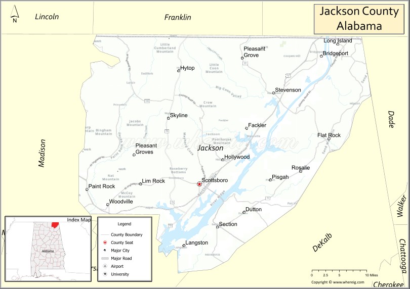
About Jackson County Map, Alabama: The map showing the county boundary, county seat, major cities, highways, water bodies and neighbouring counties.
Most Viewed Links
Map of Jackson County, Alabama
Jackson County is a county located in the U.S. state of Alabama. It`s county seat is Scottsboro. As per 2020 census, the population of Jackson County was 52773 and population density of Jackson was 49square miles. According to the United States Census Bureau, the county has a total area of 1,077.87 sq mi (2,792 km2). Jackson County was established on 1819.
Jackson County Facts
| County Info | Facts |
|---|---|
| County | Jackson County |
| County Seat | Scottsboro |
| State | Alabama |
| Country | United States |
| FIPS code | 71 |
| Established | 1819 |
| Area | 1,077.87 sq mi (2,792 km2) |
| Population | 52773 |
| Density | 49 |
| Formed / Origin | Cherokee territory |
Ctities and Towns in Jackson
| City Name | Type | Population (2020) | Pop. Density | Area |
|---|---|---|---|---|
| Bridgeport | City | 2,264 | 513.4/sq mi (198.2/km2) | 4.41 sq mi (11.4 km2) |
| Dutton | Town | 330 | 383.7/sq mi (148.2/km2) | 0.86 sq mi (2.2 km2) |
| Hollywood | Town | 914 | 102.5/sq mi (39.6/km2) | 8.92 sq mi (23.1 km2) |
| Hytop | Town | 441 | 194.3/sq mi (75.0/km2) | 2.27 sq mi (5.9 km2) |
| Langston | Town | 265 | 53.8/sq mi (20.8/km2) | 4.93 sq mi (12.8 km2) |
| Paint Rock | Town | 182 | 423.3/sq mi (163.4/km2) | 0.43 sq mi (1.1 km2) |
| Pisgah | Town | 681 | 141.9/sq mi (54.8/km2) | 4.8 sq mi (12.4 km2) |
| Pleasant Groves | Town | 426 | 116.7/sq mi (45.1/km2) | 3.65 sq mi (9.5 km2) |
| Scottsboro | City | 15,578 | 307.6/sq mi (118.8/km2) | 50.65 sq mi (131.2 km2) |
| Section | Town | 756 | 165.4/sq mi (63.9/km2) | 4.57 sq mi (11.8 km2) |
| Skyline | Town | 834 | 209.0/sq mi (80.7/km2) | 3.99 sq mi (10.3 km2) |
| Stevenson | City | 1,955 | 253.2/sq mi (97.8/km2) | 7.72 sq mi (20 km2) |
| Woodville | Town | 746 | 112.7/sq mi (43.5/km2) | 6.62 sq mi (17.1 km2) |
Places to Visit in Jackson
Top places to visit in london includes LeFleur's Bluff State Park Mayes, Eudora Welty House & Garden, The Jackson Zoo, Mississippi Petrified Forest, The Oaks House Museum, Crystal Lake, Mayes Lake, Reservoir Overlook, Bobby Cleveland Park at Lakeshore, Flowood Nature Park, Winners Circle Park.
Highways in Jackson
U.S. Highway 72, State Route 35, State Route 40, State Route 65, State Route 71, State Route 73, State Route 79, State Route 117, State Route 146, State Route 277, State Route 279.
Nearest Airports
Nearest airport of Jackson is Jackson/Vicksburg (JAN) Airport.
- Autauga County Map
- Baldwin County Map
- Barbour County Map
- Bibb County Map
- Blount County Map
- Bullock County Map
- Butler County Map
- Calhoun County Map
- Chambers County Map
- Cherokee County Map
- Chilton County Map
- Choctaw County Map
- Clarke County Map
- Clay County Map
- Cleburne County Map
- Coffee County Map
- Colbert County Map
- Conecuh County Map
- Coosa County Map
- Covington County Map
- Crenshaw County Map
- Cullman County Map
- Dale County Map
- Dallas County Map
- DeKalb County Map
- Elmore County Map
- Escambia County Map
- Etowah County Map
- Fayette County Map
- Franklin County Map
- Geneva County Map
- Greene County Map
- Hale County Map
- Henry County Map
- Houston County Map
- Jackson County Map
- Jefferson County Map
- Lamar County Map
- Lauderdale County Map
- Lawrence County Map
- Lee County Map
- Limestone County Map
- Lowndes County Map
- Macon County Map
- Madison County Map
- Marengo County Map
- Marion County Map
- Marshall County Map
- Mobile County Map
- Monroe County Map
- Montgomery County Map
- Morgan County Map
- Perry County Map
- Pickens County Map
- Pike County Map
- Randolph County Map
- Russell County Map
- St Clair County Map
- Shelby County Map
- Sumter County Map
- Talladega County Map
- Tallapoosa County Map
- Tuscaloosa County Map
- Walker County Map
- Washington County Map
- Wilcox County Map
- Winston County Map
- Alabama Counties
- Alaska boroughs
- Arizona Counties
- Arkansas Counties
- California County Map
- Colorado Counties
- Connecticut Counties
- Delaware Counties
- Florida County Map
- Georgia County Map
- Hawaii Counties
- Idaho Counties
- Illinois Counties
- Indiana Counties
- Iowa Counties
- Kansas Counties
- Kentucky Counties
- Louisiana Counties
- Maine Counties
- Maryland Counties
- Massachusetts Counties
- Michigan County Map
- Minnesota Counties
- Mississippi Counties
- Missouri Counties
- Montana Counties
- Nebraska Counties
- Nevada Counties
- New York Counties
- New Hampshire Counties
- New Jersey Counties
- New Mexico Counties
- North Carolina Counties
- North Dakota Counties
- Ohio County Map
- Oklahoma Counties
- Oregon Counties
- Pennsylvania Counties
- Rhode Island Counties
- South Carolina Counties
- South Dakota Counties
- Map of Tennessee
- Texas County Map
- Utah Counties
- Vermont Counties
- Virginia Counties
- Washington Counties
- West Virginia Counties
- Wisconsin Counties
- Wyoming Counties