Map of Lamar County - Lamar County is a county located in the U.S. state of Alabama. Lamar County Map showing cities, highways, important places and water bodies. Get Where is Lamar County located in the map, major cities in Lamar county, population, areas, and places of interest.
Lamar County Map, Alabama
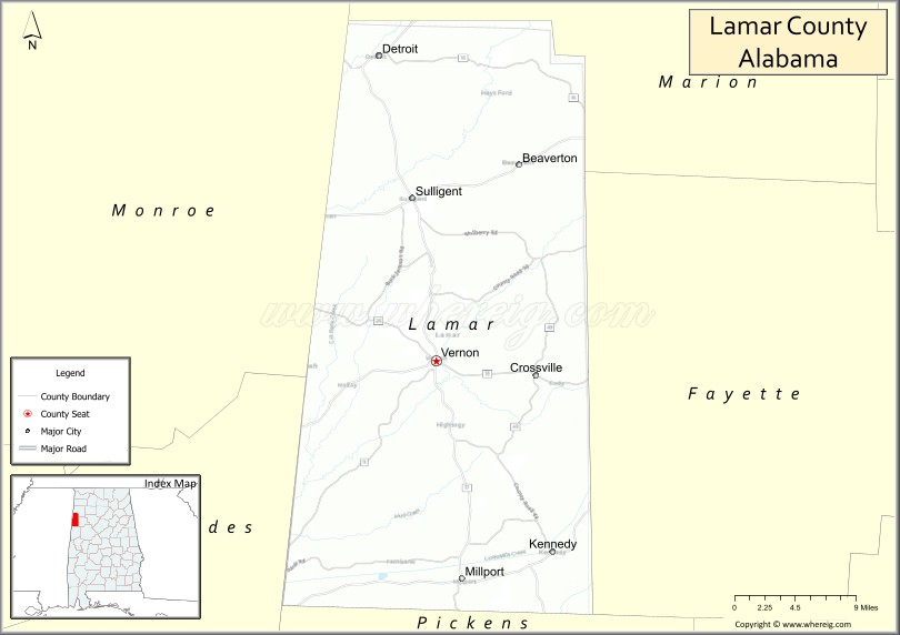
About Lamar County Map, Alabama: The map showing the county boundary, county seat, major cities, highways, water bodies and neighbouring counties.
Most Viewed Links
Map of Lamar County, Alabama
Lamar County is a county located in the U.S. state of Alabama. It`s county seat is Vernon. As per 2020 census, the population of Lamar County was 13689 and population density of Lamar was 22.6square miles. According to the United States Census Bureau, the county has a total area of 604.85 sq mi (1,567 km2). Lamar County was established on 1867.
Lamar County Facts
| Continent | North America |
| Country | United States |
| State | Alabama |
| County Seat | Vernon |
| Largest City/Town | Vernon |
| Established | February 4, 1867 |
| Total Area | 605 sq mi (1,567 sq km) |
| Land Area | 604 sq mi (1,564 sq km) |
| Water Area | 1 sq mi (3 sq km) |
| Population | 13,972 (Census 2020) |
| Population Density | 23 people per sq mi |
| Time Zone | Central Time Zone (CT) |
| Major Highways | US 278, AL 17, AL 18, AL 96 |
| Major Rivers | Luxapalila Creek, Buttahatchee River |
| Neighboring Counties | Marion County, Fayette County, Pickens County, Monroe County (Mississippi) |
| Famous For | Rural landscapes, agriculture, hunting, and the Alabama-Mississippi border region |
| Top Attractions | Vernon City Park, Lamar County Historical Museum, Luxapalila Creek, Kennedy Raceway, and Sulligent Railroad Heritage |
| Official Website | Official Website |
About Lamar County, Alabama
Lamar County is located in western Alabama along the Mississippi state line and was established in 1867. The county seat and largest city is Vernon. The county is part of a largely rural region known for farming, timber production, outdoor recreation, and small-town communities. Rolling hills, forests, and creeks characterize much of the landscape.
Cities and Towns in Lamar County, Alabama
| City/Town | Population (Census 2020) | Latitude & Longitude |
|---|---|---|
| Vernon (county seat) | 1,961 | 33.7573°N, 88.1081°W |
| Sulligent | 1,879 | 33.8909°N, 88.1348°W |
| Millport | 1,024 | 33.5637°N, 88.0814°W |
| Detroit | 230 | 34.0353°N, 88.1634°W |
| Kennedy | 428 | 33.5818°N, 87.9858°W |
| Beaverton | 181 | 33.9429°N, 88.0184°W |
| Hightogy (CDP) | 261 | 33.7444°N, 88.2324°W |
| Pine Springs (CDP) | 178 | 33.8665°N, 88.0228°W |
Best Golf Courses in Lamar County, Alabama
| Golf Course | Location | Latitude & Longitude |
|---|---|---|
| Vernon Country Club | Vernon | 33.7489°N, 88.1186°W |
| Dogwood Hills Golf Course | Sulligent | 33.9008°N, 88.1379°W |
What are Major Roads and Highways in Lamar County
Major highways connect the county to nearby regions and cities.
- US Highway 278 - east-west route connecting Vernon with Hamilton and Mississippi communities
- Alabama State Route 17 - major north-south highway linking Sulligent, Vernon, and Pickens County
- Alabama State Route 18 - connects Vernon with Fayette County and Mississippi
- Alabama State Route 96 - serves southern Lamar County and connects to Tuscaloosa County
Neighboring Counties of Lamar County
- Marion County (north)
- Fayette County (east)
- Pickens County (south)
- Monroe County, Mississippi (west)
What are Top Attractions in Lamar County, Alabama
The county offers a mix of natural and cultural attractions.
| Main Sight Name | City | Famous For |
|---|---|---|
| Lamar County Historical Museum | Vernon | Local history and heritage exhibits |
| Vernon City Park | Vernon | Family recreation and community events |
| Luxapalila Creek | Countywide | Fishing, wildlife viewing, and outdoor recreation |
| Buttahatchee River | Northern County | Paddling, fishing, and scenic landscapes |
| Kennedy Raceway | Kennedy | Local motorsports events |
| Sulligent Railroad Heritage Area | Sulligent | Historic railroad history and downtown district |
| Beaverton Community Park | Beaverton | Outdoor recreation and local gatherings |
| Detroit Historic Community | Detroit | Small-town heritage and rural scenery |
| Pine Springs Nature Area | Pine Springs | Woodland landscapes and wildlife habitat |
| West Alabama Scenic Drives | Countywide | Countryside views and photography opportunities |
Distance from Lamar County to Nearby Cities
The following distances are measured by road (driving).
- Vernon to Sulligent (Lamar County), Alabama - 12 mi (19 km)
- Vernon to Millport (Lamar County), Alabama - 14 mi (23 km)
- Vernon to Kennedy (Lamar County), Alabama - 12 mi (19 km)
- Vernon to Beaverton (Lamar County), Alabama - 18 mi (29 km)
- Vernon to Hamilton (Marion County), Alabama - 27 mi (43 km)
- Vernon to Fayette (Fayette County), Alabama - 22 mi (35 km)
- Vernon to Carrollton (Pickens County), Alabama - 28 mi (45 km)
- Vernon to Columbus, Mississippi - 33 mi (53 km)
- Vernon to Tupelo, Mississippi - 61 mi (98 km)
- Vernon to Tuscaloosa (Tuscaloosa County), Alabama - 69 mi (111 km)
- Vernon to Birmingham (Jefferson County), Alabama - 106 mi (171 km)
- Vernon to Starkville, Mississippi - 47 mi (76 km)
- Vernon to Huntsville (Madison County), Alabama - 145 mi (233 km)
References
- QuickFacts - U.S. Census Bureau
- United States Census Bureau
- United States Geological Survey (USGS)
- National Geodetic Survey
- Official County Website
- Autauga County Map
- Baldwin County Map
- Barbour County Map
- Bibb County Map
- Blount County Map
- Bullock County Map
- Butler County Map
- Calhoun County Map
- Chambers County Map
- Cherokee County Map
- Chilton County Map
- Choctaw County Map
- Clarke County Map
- Clay County Map
- Cleburne County Map
- Coffee County Map
- Colbert County Map
- Conecuh County Map
- Coosa County Map
- Covington County Map
- Crenshaw County Map
- Cullman County Map
- Dale County Map
- Dallas County Map
- DeKalb County Map
- Elmore County Map
- Escambia County Map
- Etowah County Map
- Fayette County Map
- Franklin County Map
- Geneva County Map
- Greene County Map
- Hale County Map
- Henry County Map
- Houston County Map
- Jackson County Map
- Jefferson County Map
- Lamar County Map
- Lauderdale County Map
- Lawrence County Map
- Lee County Map
- Limestone County Map
- Lowndes County Map
- Macon County Map
- Madison County Map
- Marengo County Map
- Marion County Map
- Marshall County Map
- Mobile County Map
- Monroe County Map
- Montgomery County Map
- Morgan County Map
- Perry County Map
- Pickens County Map
- Pike County Map
- Randolph County Map
- Russell County Map
- St Clair County Map
- Shelby County Map
- Sumter County Map
- Talladega County Map
- Tallapoosa County Map
- Tuscaloosa County Map
- Walker County Map
- Washington County Map
- Wilcox County Map
- Winston County Map
- Alabama Counties
- Alaska boroughs
- Arizona Counties
- Arkansas Counties
- California County Map
- Colorado Counties
- Connecticut Counties
- Delaware Counties
- Florida County Map
- Georgia County Map
- Hawaii Counties
- Idaho Counties
- Illinois Counties
- Indiana Counties
- Iowa Counties
- Kansas Counties
- Kentucky Counties
- Louisiana Counties
- Maine Counties
- Maryland Counties
- Massachusetts Counties
- Michigan County Map
- Minnesota Counties
- Mississippi Counties
- Missouri Counties
- Montana Counties
- Nebraska Counties
- Nevada Counties
- New York Counties
- New Hampshire Counties
- New Jersey Counties
- New Mexico Counties
- North Carolina Counties
- North Dakota Counties
- Ohio County Map
- Oklahoma Counties
- Oregon Counties
- Pennsylvania Counties
- Rhode Island Counties
- South Carolina Counties
- South Dakota Counties
- Map of Tennessee
- Texas County Map
- Utah Counties
- Vermont Counties
- Virginia Counties
- Washington Counties
- West Virginia Counties
- Wisconsin Counties
- Wyoming Counties