Map of Marengo County - Marengo County is a county located in the U.S. state of Alabama. Marengo County Map showing cities, highways, important places and water bodies. Get Where is Marengo County located in the map, major cities in Marengo county, population, areas, and places of interest.
Marengo County Map, Alabama
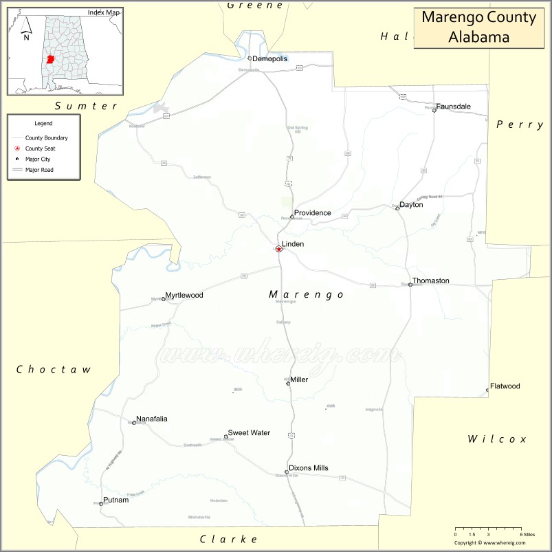
About Marengo County Map, Alabama: The map showing the county boundary, county seat, major cities, highways, water bodies and neighbouring counties.
Most Viewed Links
Map of Marengo County, Alabama
Marengo County is a county located in the U.S. state of Alabama. It`s county seat is Linden. As per 2020 census, the population of Marengo County was 18996 and population density of Marengo was 19.4square miles. According to the United States Census Bureau, the county has a total area of 976.88 sq mi (2,530 km2). Marengo County was established on 1818.
Marengo County Facts
| Continent | North America |
| Country | United States |
| State | Alabama |
| County Seat | Linden |
| Largest City/Town | Demopolis |
| Established | February 6, 1818 |
| Total Area | 983 sq mi (2,546 sq km) |
| Land Area | 977 sq mi (2,530 sq km) |
| Water Area | 6 sq mi (16 sq km) |
| Population | 19,323 (Census 2020) |
| Population Density | 20 people per sq mi |
| Time Zone | Central Time Zone (CT) |
| Major Highways | US 43, US 80, AL 10, AL 25, AL 28, AL 69 |
| Major Rivers | Tombigbee River, Black Warrior River |
| Neighboring Counties | Greene County, Hale County, Perry County, Dallas County, Wilcox County, Clarke County, Choctaw County, Sumter County |
| Famous For | Demopolis, historic riverfront communities, French colonial heritage, and the Tombigbee River |
| Top Attractions | Bluff Hall, Gaineswood, Demopolis Riverwalk, Foscue Park, and the Marengo County History & Archives Museum |
| Official Website | Official Website |
About Marengo County, Alabama
Marengo County is located in west-central Alabama and was established in 1818. The county seat is Linden, while Demopolis is the largest city. Named after the Battle of Marengo, the county is known for its rich history, riverfront scenery, and French colonial roots. The Tombigbee and Black Warrior rivers have played a major role in the county's development, transportation, and economy for more than two centuries.
Cities and Towns in Marengo County, Alabama
| City/Town | Population (Census 2020) | Latitude & Longitude |
|---|---|---|
| Linden (county seat) | 1,930 | 32.3065°N, 87.7989°W |
| Demopolis | 6,973 | 32.5146°N, 87.8364°W |
| Faunsdale | 98 | 32.4594°N, 87.5969°W |
| Myrtlewood | 128 | 32.2487°N, 87.9495°W |
| Sweet Water | 258 | 32.0951°N, 87.8614°W |
| Dayton | 45 | 32.3529°N, 87.6497°W |
| Dixons Mills (CDP) | 344 | 32.0638°N, 87.7725°W |
| Putnam (CDP) | 185 | 32.1872°N, 87.9044°W |
| Nanafalia (CDP) | 94 | 32.1185°N, 87.9881°W |
| Consul (CDP) | 64 | 32.2843°N, 87.9672°W |
Best Golf Courses in Marengo County, Alabama
| Golf Course | Location | Latitude & Longitude |
|---|---|---|
| Demopolis Country Club | Demopolis | 32.5057°N, 87.8351°W |
| Linden Golf & Country Club | Linden | 32.3120°N, 87.8013°W |
| Ravine Golf Course | Demopolis | 32.5234°N, 87.8214°W |
What are Major Roads and Highways in Marengo County
Major highways connect the county to nearby regions and cities.
- US Highway 80 - major east-west route connecting Demopolis with Selma and Meridian, Mississippi
- US Highway 43 - north-south corridor linking Demopolis, Linden, and Mobile
- Alabama State Route 10 - crosses the southern part of the county
- Alabama State Route 25 - connects Faunsdale, Linden, and northern communities
- Alabama State Route 28 - links Demopolis with Livingston and Camden
- Alabama State Route 69 - provides access to Greensboro and Tuscaloosa regions
Neighboring Counties of Marengo County
- Greene County (north)
- Hale County (northeast)
- Perry County (east)
- Dallas County (east-southeast)
- Wilcox County (south)
- Clarke County (southwest)
- Choctaw County (west)
- Sumter County (northwest)
What are Top Attractions in Marengo County, Alabama
The county offers a mix of natural and cultural attractions.
| Main Sight Name | City | Famous For |
|---|---|---|
| Gaineswood | Demopolis | National Historic Landmark and antebellum mansion |
| Bluff Hall | Demopolis | Historic Greek Revival mansion museum |
| Demopolis Riverwalk | Demopolis | Scenic views of the Tombigbee and Black Warrior rivers |
| Foscue Park | Demopolis | Camping, fishing, and outdoor recreation |
| Marengo County History & Archives Museum | Linden | Local history exhibits and genealogy resources |
| Old Marengo County Courthouse | Linden | Historic county landmark |
| Lyon Hall | Demopolis | Historic home and museum |
| Demopolis Public Square Historic District | Demopolis | Historic architecture and shopping |
| Tombigbee River | Countywide | Boating, fishing, and waterfront recreation |
| Black Warrior River | Countywide | Wildlife viewing and scenic landscapes |
| Sweet Water Historic Area | Sweet Water | Small-town heritage and Black Belt culture |
| Faunsdale Plantation District | Faunsdale | Historic plantation architecture |
Distance from Marengo County to Nearby Cities
The following distances are measured by road (driving).
- Linden to Demopolis (Marengo County), Alabama - 16 mi (26 km)
- Linden to Sweet Water (Marengo County), Alabama - 15 mi (24 km)
- Linden to Myrtlewood (Marengo County), Alabama - 10 mi (16 km)
- Linden to Faunsdale (Marengo County), Alabama - 25 mi (40 km)
- Linden to Greensboro (Hale County), Alabama - 35 mi (56 km)
- Linden to Selma (Dallas County), Alabama - 54 mi (87 km)
- Linden to Camden (Wilcox County), Alabama - 34 mi (55 km)
- Linden to Livingston (Sumter County), Alabama - 39 mi (63 km)
- Linden to Butler (Choctaw County), Alabama - 33 mi (53 km)
- Linden to Grove Hill (Clarke County), Alabama - 36 mi (58 km)
- Linden to Tuscaloosa (Tuscaloosa County), Alabama - 78 mi (126 km)
- Linden to Montgomery (Montgomery County), Alabama - 98 mi (158 km)
- Linden to Mobile (Mobile County), Alabama - 128 mi (206 km)
- Linden to Meridian, Mississippi - 77 mi (124 km)
Nearest Airports
Nearest airport of Marengo is Chicago Rockford International Airport (RFD).
References
- QuickFacts - U.S. Census Bureau
- United States Census Bureau
- United States Geological Survey (USGS)
- National Geodetic Survey
- Official County Website
- Autauga County Map
- Baldwin County Map
- Barbour County Map
- Bibb County Map
- Blount County Map
- Bullock County Map
- Butler County Map
- Calhoun County Map
- Chambers County Map
- Cherokee County Map
- Chilton County Map
- Choctaw County Map
- Clarke County Map
- Clay County Map
- Cleburne County Map
- Coffee County Map
- Colbert County Map
- Conecuh County Map
- Coosa County Map
- Covington County Map
- Crenshaw County Map
- Cullman County Map
- Dale County Map
- Dallas County Map
- DeKalb County Map
- Elmore County Map
- Escambia County Map
- Etowah County Map
- Fayette County Map
- Franklin County Map
- Geneva County Map
- Greene County Map
- Hale County Map
- Henry County Map
- Houston County Map
- Jackson County Map
- Jefferson County Map
- Lamar County Map
- Lauderdale County Map
- Lawrence County Map
- Lee County Map
- Limestone County Map
- Lowndes County Map
- Macon County Map
- Madison County Map
- Marengo County Map
- Marion County Map
- Marshall County Map
- Mobile County Map
- Monroe County Map
- Montgomery County Map
- Morgan County Map
- Perry County Map
- Pickens County Map
- Pike County Map
- Randolph County Map
- Russell County Map
- St Clair County Map
- Shelby County Map
- Sumter County Map
- Talladega County Map
- Tallapoosa County Map
- Tuscaloosa County Map
- Walker County Map
- Washington County Map
- Wilcox County Map
- Winston County Map
- Alabama Counties
- Alaska boroughs
- Arizona Counties
- Arkansas Counties
- California County Map
- Colorado Counties
- Connecticut Counties
- Delaware Counties
- Florida County Map
- Georgia County Map
- Hawaii Counties
- Idaho Counties
- Illinois Counties
- Indiana Counties
- Iowa Counties
- Kansas Counties
- Kentucky Counties
- Louisiana Counties
- Maine Counties
- Maryland Counties
- Massachusetts Counties
- Michigan County Map
- Minnesota Counties
- Mississippi Counties
- Missouri Counties
- Montana Counties
- Nebraska Counties
- Nevada Counties
- New York Counties
- New Hampshire Counties
- New Jersey Counties
- New Mexico Counties
- North Carolina Counties
- North Dakota Counties
- Ohio County Map
- Oklahoma Counties
- Oregon Counties
- Pennsylvania Counties
- Rhode Island Counties
- South Carolina Counties
- South Dakota Counties
- Map of Tennessee
- Texas County Map
- Utah Counties
- Vermont Counties
- Virginia Counties
- Washington Counties
- West Virginia Counties
- Wisconsin Counties
- Wyoming Counties